But of course, a few people didn't have quite that sort of Friday as they got ready for a storm or two!
Hurricane Grace
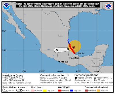
Hmm... she fell off the bandwagon. She was behaving so well, but although she's on the right track, her intensity decided to make a run for it. She's at 20.7N, 96.3W, heading W at 10mph. She is close to landfall now and will be making landfall south of Tuxpan, Mexico very soon:
That's pretty much on target... with a note that she may actually cross Mexico, despite the mountains, and enter the Pacific to reform into a new Tropical Storm. This is not the first time a storm has done this, by the way and she will become a he... as TS Marty.
But she intensified more than expected - in the last few hours she underwent rapid intensification (which is an area of very active research). We knew she was going to get stronger because the water is very warm, but she intensified more than expected and is now a major cat 3 hurricane with winds of 120mph, central pressure 967mb (cat 3 range: 111-129mph). She is already getting a little weaker as she is interacting with land:
She is already dumping a lot of rain (accompanied by thunderstorms to Mexico), and she will most likely be a strong cat 2 or weak cat 3 at landfall.
Tropical Storm Henri
Now, for the storm I've had the most queries on today. I hadn't realized how many people I knew in the northeast! He is at 32.3N, 73.5W, heading N at 9mph, and as forecast, he made that northward turn:
He has also started to move a little faster will pick up speed even more as he moves between the high pressure to the east and low pressure to the west.
Henri is still officially a Tropical Storm trying to get past that wind shear, but he is a strong one with 70mph winds, central pressure 994mb (TS range: 39-73mph). As we saw yesterday, his convection shows a lot of very heavy rain and some thundery weather (red and dark red):
As I said, he is still under some strong wind shear, which we can see as the clouds are streaming to the south. I agree with the NHC on the current intensity - he is almost a cat 1 storm but not quite there yet. The clues are in the vorticity (circulation) maps which show the wind shear in his structure, but also show some circulation now in the upper levels of the troposphere (a sign that he is a hurricane). The lowest level map at 850mb:
And in the mid-levels of the troposphere (500mb):
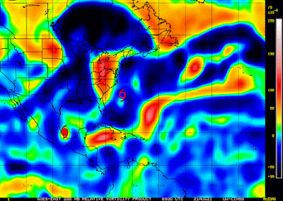
As we saw yesterday, the circulation in the mid-levels doesn't align with the lower levels. However, unlike yesterday, there is now a signal of vorticity in the upper level of the troposphere (200mb):
It's that green dot to the southwest of the symbol that is Henri - again, it is shifted to the southwest compared to the mid-levels, so there is a lot of wind shear in the higher levels of the troposphere as well which is inhibiting his development. Until that wind shear gets weaker, he will not get very strong. He will pick up speed and move over the warmest waters fairly quickly so as he approaches land, he won't have warm water to draw from by Sunday. I think, at the most, he will be in the cat 1 range but may even be a strong TS.
Also, remember to keep an eye on that entire Cone of Uncertainty - I think he will shift a little more.
Good luck in the preparations! I'll be back tomorrow, including some daytime satellite imagery.
Toodle pip,
J.
--------------------------------------
DISCLAIMER:
These remarks are just what I think/see regarding tropical storms - not the opinion of any organization I represent. If you are making an evacuation decision, please heed your local emergency management and the National Hurricane Center's official forecast and local weather service announcements. This is not an official forecast. If I "run away, run away" (Monty Python), I'll let you know.


No comments:
Post a Comment