Not much time for dilly dallying with two pesky storms out and about, so I’ll jump straight to the business at hand…
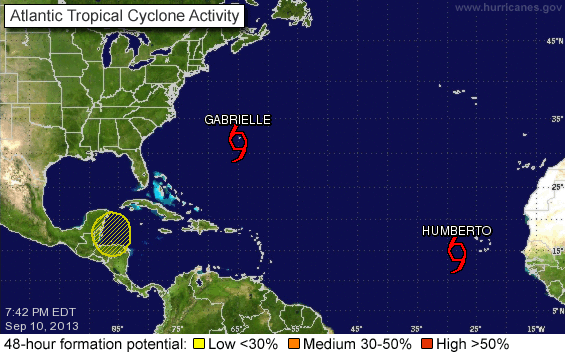
Tropical Storm Gabrielle
Officially she is currently at 32.0N, 65.0W, heading N at 8mph. Winds are 60mph, central pressure is 1004mb. With winds of 60mph, this makes her a medium intensity storm (TS range: 39-73mph). She is passing pretty much over Bermuda...

… that poor little island, right in the middle of the circle known as Gabrielle. The same island that the NHC wrote about at 8pm AST: “...TROPICAL STORM CONDITIONS OCCURRING ON BERMUDA AS GABRIELLE APPROACHES...” and at 11pm AST said: ...GABRIELLE SLOWS AS IT NEARS BERMUDA... TROPICAL STORM CONDITIONS TO CONTINUE THROUGH WEDNESDAY MORNING... “.
Awww. <insert that screechy sound of a record scratching to a halt> Wait! Are they referring to this little island that experienced, at the most, a few relatively light rain showers at 6pm AST and that, by 11pm AST, had hardly any rain at all?


Or maybe they are talking about the wind speeds on Bermuda? Those strong sustained winds… that barely reached 40mph according to ACTUAL OBSERVATIONS on the island (gusts were stronger of course, but that’s not a sign of a tropical storm):

Or maybe it’s the island from which I received numerous weather reports throughout the day from our fabulous and diligent on-the-ground reporter, Steven B.?
11:52am: I’ll write to you about the storm tonight. It’s breezy and overcast but very little rain yet.
3:47pm: Still not raining and the wind has abated somewhat. Hardly storm of the century stuff.
8:32pm: Well it’s starting to rain. Not heavily and the strong winds (25-30 knots) are blowing the rain away. High winds. Making a lot of noise at the tree tops but not much below.
9:09pm: Nothing here J, just a bit of rain and wind. You wouldn’t worry too much if you left your raincoat at home.
9:49pm: Going to bed mate. No wind no rain
Not really a compelling case for ‘tropical storm conditions’ on Bermuda, is it?
I think she is barely a tropical storm now. There is some convection and strong circulation, but really only in the very lowest levels of the troposphere – even the structure in the middle of the troposphere is more like a front than a tropical storm. She is experiencing strong wind shear (and is heading into stronger wind shear) which is pulling her apart. Sea surface water temperatures are around 27 deg C. Definitely warm enough to keep her going for a little longer, but the warm water is in a very shallow layer near the surface – maybe the upper 10m – so nothing to make her get any stronger.
More tomorrow on the continuing saga of this poor misunderstood storm. Now for the next one…
Tropical Storm Humberto
Officially he is currently at 15.4N, 28.4W, heading NW at 7mph. Winds are 70mph, central pressure estimated to be 995mb.
Well I reckon the NHC missed the hurricane boat on this one! Just imagine if they had been on board, they could have checked ‘hurricane’ off their 2013 to-do list! I really think Humberto was a hurricane yesterday evening. I also wonder if the NHC were thinking about that this morning. From their 11am advisory:
“SATELLITE IMAGES INDICATE THAT HUMBERTO HAS STOPPED INTENSIFYING... AT LEAST FOR THE MOMENT. RECENT MICROWAVE DATA SHOWED THAT THE STORM HAD A SMALL MICROWAVE EYE OVERNIGHT...BUT THAT FEATURE HAS SINCE DISSOLVED AND HAS BEEN REPLACED BY A LARGER BUT BROKEN INNER BAND OF CONVECTION. IN SOME SENSE...THIS SUGGESTS AN EYEWALL REPLACEMENT...EXCEPT THAT HUMBERTO IS STILL A TROPICAL STORM.”
An eye? An eyewall replacement? Walks like a Hurricane, sounds like a Hurricane, had the circulation signal throughout the troposphere of a Hurricane, had the convection of a Hurricane. Must be a Tropical Storm. Sigh.
And of course, as their luck would have it, today he encountered some dry air which really inhibited his development so NOW he really is a Tropical Storm!
He did remain on a little more westward track, making a move to the northwest quite late in the day today. However, this is still more-or-less within the cone so I'm good with that track. I also agree with the northward motion for now because the high pressure in front of him and to his north has dissipated. I’ll go with the official track for the next two days... assuming he survives…

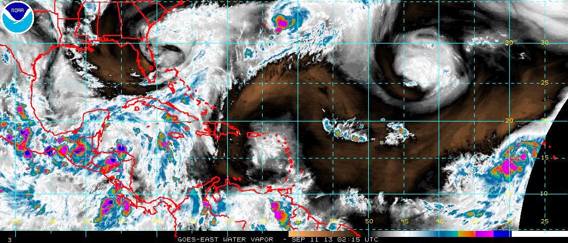
From this satellite image of water vapor, we see that as he moves north he runs into a little problem that we in the business like to call ‘dry air’. We saw the effect of this today in slowing his development and decreasing his convection. We’ll see how he fares but I wouldn’t be overly surprised if the NHC decide to cross the barrier and upgrade him to hurricane tomorrow – the circulation is still pretty good throughout the troposphere, although it is a little less defined in the lower troposphere compared to yesterday.
That’s all for today. What a lark. Goodness me. I’ll be back for more giggles (maybe even some from Bermuda) tomorrow.
Toodle pip!
J.
Blogs archived at http://jyotikastorms.blogspot.com/
Twitter @JyovianStorm
-------------------------------
DISCLAIMER: These remarks are just what I think/see regarding tropical storms - not the opinion of any organization I represent. If you are making an evacuation decision, please heed your local emergency management and the National Hurricane Center's official forecast and the National Weather Service announcements. This is not an official forecast. If I "run away, run away" (Monty Python), I'll let you know.
-----------------------------