
Hurricane Irma
Those of us who are not busy evacuating, boarding up, or getting supplies (of ice cream and wine) have been watching the news coming in from the islands Hurricane Irma has already visited; here’s a quick an island-by-island summary from the Guardian.
Both the U.S. Virgin Islands and Puerto Rico are U.S. territories. I have not yet heard from my regularly featured intrepid on-the-ground reporter, Tom J. from St. Thomas (USVI), and as far as I know, no-one has heard from his family yet either. Tom and Sheri: the Florida branch of your family are hoping to hear from you soon. Reports of extensive damage to buildings, impassable roads, and no landlines and cell phones from the USVI indicate that it is pretty rough there, as it is in many other places.
As for Puerto Rico, following Irma, 70% of the population are without power; to put this into perspective, imagine if 70% of everyone living in both Rhode Island and New Hampshire suddenly lost power for days, weeks, or possibly months! And losing power is just a small part of what Irma has brought about.
Looking forward to what is in her path; she has hit the Turks & Caicos and is now at 21.3N, 72.4W, heading WNW at 16mph. Although slightly weaker, she is still a monster cat 5 storm (cat 5 range > 157mph) with winds of 165mph, central pressure of 920mb.
It looks like she did take a slightly more westward path earlier today but is now back on a WNW track:

The convection has definitely decreased (less red!), which is a sign of weakening, but it looks like she has grown in girth. From this water vapour satellite image, you can see that her cloud field is now a near-perfect circle again – a few hours ago, it wasn’t quite the case:
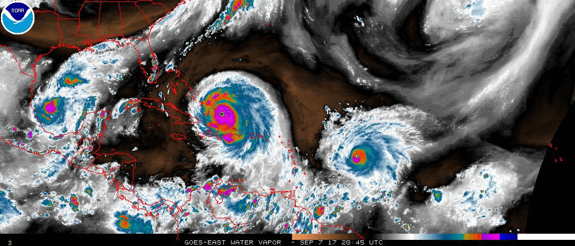
Unfortunately, there is a lot of thundery convection (the red and orange parts) over Haiti, which is always bad. Without trees to hold the soil in place, they are susceptible to major flooding and landslides under lesser storms. Sigh (shaking my head).
I don’t see much shift in this generally westward track for a couple of days – and of course, we don’t know quite where she will make her turn to the north:

If you have been paying any attention (haha) you may have figured out that we still don’t know where this turn will take place because the forecast track is now slowly shifting back towards the west side of Florida. Again, it is not a done deal though - the entire cone is the thing to look out for.
One way you can more track her progress is through the satellite images – even the water vapour one above. She is supposed to meet up with the low-pressure front that is coming down across the US. That is shown as the band of clouds that are sweeping across the northern edge of Florida. When she meets that band is approximately when she will turn.
We are now looking at Sunday for her to reach Florida, and the cone still covers almost all of Florida at 3 days out. It is really difficult to say exactly where she will turn to the north but there are four possible scenarios...
1. She stays on a WNW track within the next 1-1.5 days: In this case, she will remain over water. The problem is she if she moves between the Bahamas and Cuba, she will be moving over warmer water (as if it wasn’t hot enough!). This means she will remain very strong – a cat 5 – with nothing in her way as there is no wind shear to speak of until she gets closer to Florida.
2. She takes a slightly more westward track for the next 1-1.5 days: In this case, she will get closer to Cuba, and may even make landfall for a short while (quite bad for Cuba). If this happens, her intensity will definitely take a hit and she will most likely be a cat 3 or 4 as she emerges - depending on how long she is over Cuba.
3. She takes a slightly more westward track for the next 2-3 days: In this case, she will cross Cuba and move into the Gulf before connecting with the front, which would mean a possible west Florida hit. Be she will be weaker for having interacted with Cuba.
4. The front moves down a little faster over the next 2 days: In this case, it could scoop her away from a Florida landfall and instead she will skirt the eastern seaboard. In this scenario, she won’t interact with land as much and remain strong until she runs into wind shear as she goes north along Florida.
Given the cone, unfortunately any of them are possible at the moment but the intensity will change depending on the track. Tomorrow I will look at the path beyond Florida.
Regarding evacuations… I hope you are all listening to your local emergency managers!! There is an historically large evacuation underway in Florida! I know there are over 650,000 people under mandatory evacuation in Miami-Dade alone, and from the photos, it looks like many of you are being cautious and leaving early (jolly good). However, as I said before: definitely evacuate to run from the water (coastal or river flooding). If you can hide from the wind, then hide and don’t evacuate (unless you are in the path of a direct hit from a cat 4 or 5 – in which case, I would ‘run away, run away’). The roads are going to get clogged up (actually, I believe they already are), and you need to be in a safe spot by Saturday evening!
Also, for Floridians, before she gets too close, here are a few lessons of storms past that I picked up as I watched hurricanes come across Florida:
1. If she makes landfall on one side of the state and crosses to the other, the chances are she will drop by 2 category levels, so even if you are on the other side, you may expect a hurricane. We had this in 2004/2005 – I think it was Frances or Jeanne (or both!) – a cat 3 on the east coast, a cat 1 by the time they got to the west coast and the Tampa Bay area.
2. If she passes over the Everglades, don’t expect a huge drop in intensity. That area is a not land, it’s a big swamp! There is plenty of hot water for her to go over.
3. If she passes over Lake Okeechobee, don’t expect a huge drop in intensity. That is a very large lake.
Good luck and stay safe!!
Hurricane Jose
Hurricane Jose has been growing, and is now officially a mid-sized cat 3 storm with winds of 120mph (cat 3 range: 111-129mph). I would agree with this as his eye is well formed and has been pretty sustained during the day today. Central pressure is 966mb:

He is at 15.6N, 53.9W, heading W at 18mph. His track, unfortunately, takes him to the northeastern Caribbean islands and according to the NHC, he will be a major hurricane (cat 3 or higher) when he gets there around Saturday:

I think he may be weaker because there is definitely some wind shear between him and the islands at the moment. The sea surface temperatures are around 28 deg C, so warm enough to sustain him, but not as warm as Irma. Even as a regular old hurricane, he is not who needs to be knocking on the doors of any islands any time soon!
Hurricane Katia
I finally agree with the NHC today on Katia (let there be a bit of rejoicing, but not too much) – we agree that she is now a weak cat 1 storm. They really jumped on her too soon! Officially, her winds are 85mph, central pressure is 982mb. She continues to have a large amount of convection (rain and whatnots) and there is now some good circulation (vorticity) throughout the entire troposphere. The circulation in the upper troposphere means she is a hurricane, but she doesn’t have an eye yet, so she is weaker than 90mph… hence I agree with 85mph:

She is currently at 21.5N, 95.1W, heading W at a whopping 3mph. At this rate she’ll cool the water beneath her and stop her own food supply! She is still forecast to head to Mexico, arriving there tomorrow (Friday) night - I would go with the NHC on their track at this point:

That’s it for today. I will try and get a note out earlier in the day tomorrow – I know, the time lag from where I sit to where those of you in the storm's path are is not too wonderful. I really need a TARDIS!
Ciao!
J.
Blogs archived at http://jyotikastorms.blogspot.com/
Twitter @JyovianStorm
-------------------------------
DISCLAIMER: These remarks are just what I think/see regarding tropical storms - not the opinion of any organization I represent. If you are making an evacuation decision, please heed your local emergency management and the National Hurricane Center's official forecast and the National Weather Service announcements. This is not an official forecast. If I "run away, run away" (Monty Python), I'll let you know


No comments:
Post a Comment