
Morning
cuppa tea and very quick update…
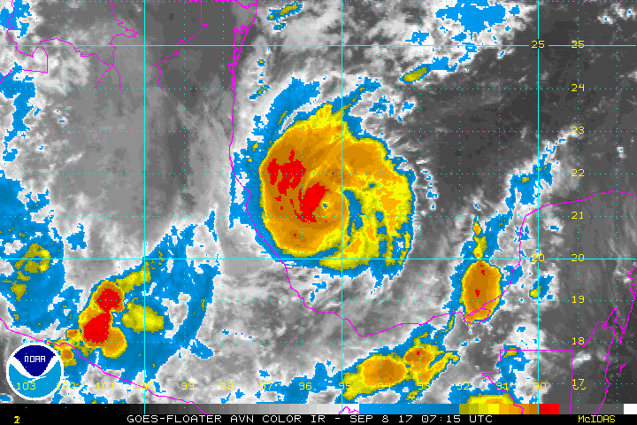
Hurricane Irma
She has winds
of 150mph, central pressure 927mb, and has been downgraded to an extremely
strong cat 4 hurricane (cat 4 range: 130-156mph) and could oscillate back up,
although the interaction with land is having an effect (finally!) – Cuba and
the Bahamas are getting deluged though!:


She is
currently at 22.0N, 75.3W, heading WNW at 14mph. The location of that turn is
still unknown, so no change there – she could go up the middle of Florida (best
case for rapid weakening because of interaction with land), or to either side
(worst case for weakening is up the east coast and over the Florida Current/Gulf
Stream, although there is some wind shear which would weaken her part way up
the state):

Hurricane Jose
Hurricane
Jose is now officially apparently the same as Hurricane Irma – a cat 4 with the
exact same wind speeds of 150mph… however his central pressure is much higher
at 942mb. They sent a plane
in and then have estimated the winds from that - I think it's a little high on the estimate, but I will go with their data because in terms of the physics (ooh, lovely physics! :-)), this one is a little
more complicated – the upper troposphere structure shows that he is not a
tropical storm up there, but actually part of a front now (which, even in
winter, can be windy):
 .
.
Strictly
speaking I would say he is a cat 3 from his structure, appearance, and even central pressure, but I can see why they estimate such high winds given what is above him. Anyway,
there is still some wind shear ahead of him and before he gets to the islands, which you can already begin to see as the clouds are not as symmetrical as they are for Irma – it will hopefully help to reduce his impact a bit - although he will still be a relatively strong hurricane. Even a cat 2 or 3 to the islands that have just been hit is going to be tough.
He is
currently at 16.3N, 57.1W heading WNW at 18mph:

Not a huge
change to the track.
Hurricane Katia
Hmm… officially,
she is a weak-to-mid-sized cat 2 storm with winds of 100mph, central pressure
975mb (cat 2 range: 96-110mph):

There isn’t
a very good eye so I would actually say her winds are right around 90mph, which
would make her a cat 1 storm. She is still on track for landfall
tonight/early tomorrow.
She is at 21.0N, 95.8W heading WSW at 5mph:

Tea finished,
work begins…
More later!
J.
Blogs
archived at http://jyotikastorms.blogspot.com/
Twitter @JyovianStorm
-------------------------------
DISCLAIMER: These remarks are just what I think/see regarding tropical storms - not the opinion of any organization I represent. If you are making an evacuation decision, please heed your local emergency management and the National Hurricane Center's official forecast and the National Weather Service announcements. This is not an official forecast. If I "run away, run away" (Monty Python), I'll let you know.
-->


No comments:
Post a Comment