Tropical Storm Katia
Like some famous celebrities, TS Katia’s weight has fluctuated like a yo-yo over the past 2 days (according to the NHC). I’m sure next week she’ll be signing a contract with Jenny Craig to do a series of TV commercials. ;-)
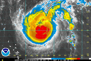
She is now a strong Tropical Storm yet again (for the third time), with winds of 70mph and a central pressure of 993mb. In my opinion I think she has not really changed from being a Cat 1 (range: 74-95mph) storm because her circulation is still good throughout the troposphere, her convection looks pretty ferocious (infra-red satellite image below), and she has some decent bone structure. I assume the NHC are oscillating between 70mph (TS) and 75mph (cat 1) because they are bored? Anyway, they forecast that she’ll be back at hurricane strength tomorrow (for the third or fourth time – I’ve lost count)…. For a couple of minutes anyway. ;-)

She’s at around 20.4N, 57.3W moving WNW at 10mph. She is still being a little hindered by high pressure to her north, which is why she is still on a slightly more westward track than the forecast called for. She is also a little slower that yesterday, again because of the high pressure. She’s trying to move north, poor thing. The good news is that that high pressure has almost eroded and I think that tomorrow we’ll start to see her speed up a bit and move NW again.
Tropical Storm Lee
I think they might have had him in the wrong place yesterday, because by the time I looked in on him today (around 10am), he was already at the LA coastline (1.5 days ahead of the forecast) and northwest of the forecast center of cone I had posted yesterday. He is a bit messy, but it looks like he is currently somewhere around 29.8N, 93W, moving in a squiggly (technical term! ;-)) westwardish direction along the LA coast (officially NNW at 4mph). Actually I think he has already made the leap onto land, pretty much where I thought yesterday - on the western edge of that cone of uncertainty.
His winds are around 50mph, making him a weak Tropical Storm (range: 39-73mph), central pressure 988mb. As expected, he has dumped a lot of rain over the northern Gulf coast, east of his center. However, both the circulation and the convection have decreased a lot now (which is why I think he might be over land already). The forecast has him as a Tropical Storm until Monday afternoon. I think this is unlikely. I can’t see him remaining as a TS until then, especially when he is a weak TS now.
I expect they will say that he has made landfall in the next advisory.
That’s it for today. Time for some wine (and cheese) and aliens! (Oh, today I went to talks by Martin Landau and Ernest Borgnine. Before you ask, yes, they are both still alive! ;-) They were both charming. It was a real delight.)
More adventures tomorrow!
Adieu,
J.
Blogs archived at http://jyotikastorms.blogspot.com/
Twitter @JyovianStorm
-------------------------------
DISCLAIMER: These remarks are just what I think/see regarding tropical storms - not the opinion of any organization I represent. If you are making an evacuation decision, please heed your local emergency management and the National Hurricane Center's official forecast and the National Weather Service announcements. This is not an official forecast. If I "run away, run away" (Monty Python), I'll let you know.
-------------------------------


No comments:
Post a Comment