You know...
Well, I suppose it's only another three days until the real Friday stands up. :-) Busy day here and a busy day in the Atlantic.Hurricane Fiona
She visited the eastern Turks and Caicos today but is now moving north at a bit of a slow 8mph and is currently at 23.2N, 71.8W. The good news for Bermuda is that the track has, indeed, shifted a little to the west so you are no longer in the cone of uncertainty:
So feel free to rejoice on Bermuda... although not too much because she is still a big and strong storm and she'll be zipping by soon. Winds are now officially at 125 mph which means she is a major Cat 3 storm (cat 3 range: 111-129mph), central pressure is 947mb. She has a good looking eye which is very persistent, so I suspect she may actually be a cat 4 storm, not a cat 3 storm.
I think the convection has decreased because there are fewer areas of really dark red in the infrared satellite imagery. Although she is over warm waters of 29 - 30 deg C, which would keep her intensity high, there is a little bit of wind shear and, more importantly, it looks like that dry air to her west has been pulled into the system - which we can see in that green/blue area that has wrapped around her. There is still some dry air to the west and you can see the drier air in the storm more clearly from the water vapour imagery:
We will see how much of an impact this will make in the long run - the thing to watch for is whether that dry air gets pulled in towards the center and wraps around the eye a little more tightly.
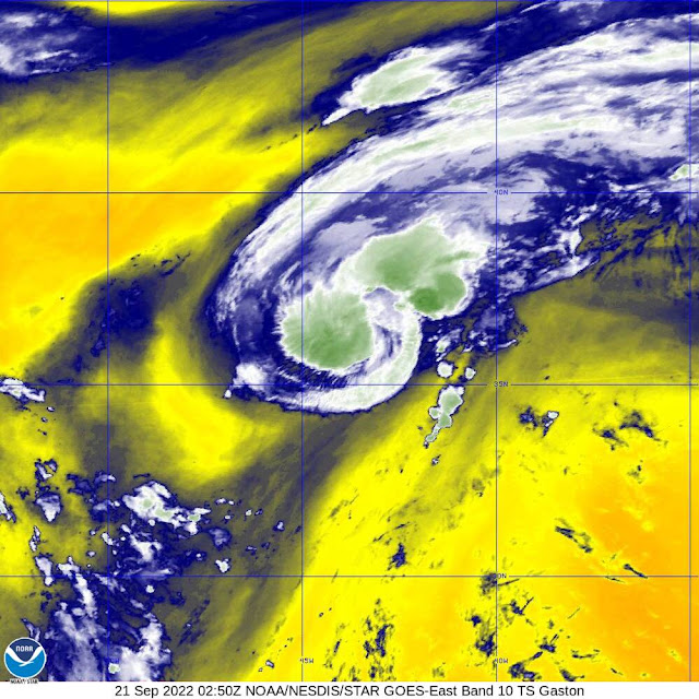
His circulation is good in the lower half of the troposphere, which is an indication that he is a Tropical Storm so I agree with the NHC on this intensity. Unlike Gaston of Beauty & The Beast fame, this Gaston is a bit scrawny:
That's because he is fairly far north where the sea surface temperature is right around 26 deg C and although there isn't a lot of wind shear, he is in an area of dry air...
This image is from the University of Wisconsin CMISS page, which is an excellent website for this sort of handy information. If you want to have a look for it yourself (and I am sure you do!), go to this website: http://tropic.ssec.wisc.edu/tropic.php. Click on the colour block in the lower map for the part of the world you are interested in (North Atlantic in this case) and in the drop-down menu (amongst a number of other things) you will see 'Saharan Air Layer Analysis;. Click on this and you will see the map above. Easy peasy! Now you are all experts in the SAL! :-) <End Science and Forecasting Alert!>
Blogs archived at http://jyotikastorms.blogspot.com/
DISCLAIMER:
These remarks are just what I think/see regarding tropical storms - not the opinion of any organization I represent. If you are making an evacuation decision, please heed your local emergency management and the National Hurricane Center's official forecast and local weather service announcements. This is not an official forecast. If I "run away, run away" (Monty Python), I'll let you know.


No comments:
Post a Comment