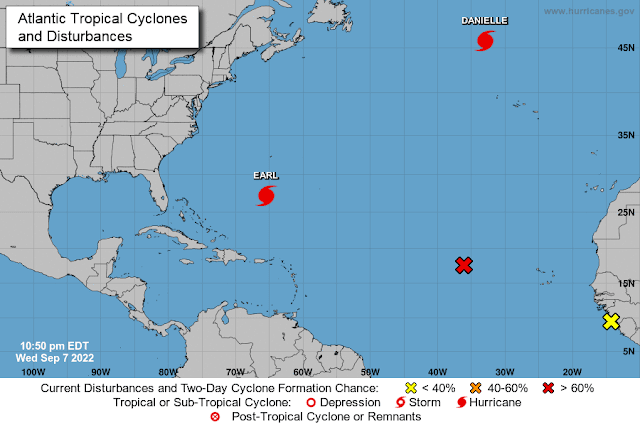
That was nice and refreshing; I had a lovely nap for the entire month of August - not a peep from the Atlantic! I have just recovered from a visit to wonderful world of Planet DragonCon and I see that right on cue... Mother Nature is out there playing snooker... haha (well I thought that was a clever little word play anyway ;-)).
So, let's see... what happened when I was away from Earth:
Hurricane Danielle
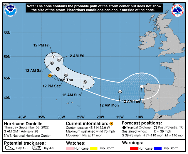
She became a named Tropical Storm in the middle of the Atlantic on the 1st of September - 6 days ago - and has been merrily dancing out there since then, not causing too much of a bother to anyone (unless you are sailing in the Atlantic). She is currently at 45.6N, 32. 9W and heading NE at 17mph:
She was heading to the UK but now that the new Prime Minister has been announced she has decided not to bother and is about to do a lovely pirouette and head to umm... northwestern Spain/Portugal (where I know a lot of people - oopsies). But the good news is that she is just barely a cat 1 storm with winds of 75 mph (cat 1 range: 74 - 95mph), central pressure 975mb and is already weakening so by the time she gets to that part of the world next week, she should be just a blustery breeze with maybe some clouds/rain:
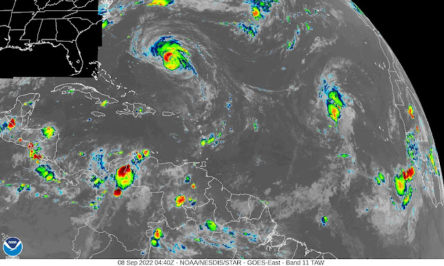
You can see from the infrared satellite imagery that she doesn't have a lot of convection (rain or stormy weather). Ooh... first Technical Alert of the season coming right up... :-)
<Technical Alert!> Satellite Imagery: I mainly use three sorts of satellite images: visible, water vapour (with a 'u'), and infrared. The visible one is obvious... it is what you would see if you took a black and white photo. Best used during daylight hours of course! ;-) The water vapour imagery is also relatively obvious... it shows how much water vapour there is in the atmosphere. Brown areas are dry (think of parched deserts) and any other colour indicates some amount of water vapour. The infrared satellite imagery is the most interesting though (in my humble opinion). This one not only shows where the storm is, but it also gives us an indication of how strong it is and what sort of weather we have. The colours represent how high the clouds reach into the atmosphere because they are based on the temperature at the top of the could (which is what the satellite sees). It gets colder the higher you get in the troposphere (the lowest level of the atmosphere) so we can tell from cloud top temperature how high the clouds are and therefore how strong the convection is! Red colours would be very big high clouds with some of the coldest temperatures, and blues and whites are lower, warmer clouds. The redder the cloud colour, the more active the convection. My general rule of thumb is (having seen these images and lived under the clouds at the same time) is that blue, green and yellow areas are mostly just clouds, with some rain in the yellow areas. But as you get to the orange and red/dark gray (which you see below in Earl), you get thunderstorms and possibly tornadoes. <End Technical Alert!>
Hurricane Earl
Earl was named a Tropical Storm on the 2nd of September and upgraded to a Hurricane yesterday. He's also been hanging out in the Atlantic and not causing too much consternation so far (he missed the islands in the northwestern Caribbean). But he now at 27.2N, 65.5W heading N at 9mph in the general area of Bermuda, where I imagine everyone is out playing golf at the moment because the wind field hasn't quite got to them:
I would say this track line is fairly good at this point - it is less than 24 hours away from the passing Bermuda and I think the NHC track within that timeframe is on target. So although it won't be a direct hit, I expect it to be a bit of a wet and blustery day tomorrow (much trickier for golfing my Bermudian friends, but a good time for a Dark & Stormy?). Winds are currently 100mph, central pressure is 970mb, which makes him a mid-size cat 2 storm (cat 2 range: 96-110mph). He does have a lot of convection and the outer cloud bands are already over the island...
He is over warm water and the wind shear is decreasing, so the expectation is that he will intensify and will be at least a cat 3 storm as he passes close to Bermuda, and almost a cat 4 by the time he leaves that area.
Hurricane supplies in? Welly boots dusted off? Deflector shields engaged? Good. Be safe out there!
Atlantic Blobette
This potential Tropical Storm is currently far from land in the middle of the tropical Atlantic at around 17.5N, 36 W, heading WNW at 15-20mph:
She has some convection, but her circulation is not very well developed at the moment - although it is getting slowly stronger. I'll keep an eye on this but for now... there is one more storm!
Hurricane Kay
For those of you still awake and paying attention (Greg!), this one is not in the Atlantic... it's in the eastern Pacific, near Baja, California (not to be confused with LaLa, California - where we have pale orange skies today from fires versus grey skies from clouds!). She is currently at 23.2N, 113W, heading NNW at 14mph and is a strong category 1 hurricane with winds of 90mph, central pressure 975mb (cat 1 range: 74-95mph):
The good news is that she is weakening - although the wind shear is weak (which would be helpful for intensification), working against that is her interaction with the peninsula and she is moving over cooler water as she continues to head north. So, by the time she clips land tomorrow (Thurs) I think she should barely be a cat 1 storm or a strong Tropical Storm with winds around 70-75mph (TS range: 39-73mph). For anyone in the area, it will be wet and windy and of course... surfs up! Be safe out there.
That's all folks! (until tomorrow anyway).
Toodles,
J.
Blogs archived at http://jyotikastorms.blogspot.com/
Twitter @JyovianStorm
--------------------------------------
DISCLAIMER:
These remarks are just what I think/see regarding tropical storms - not the opinion of any organization I represent. If you are making an evacuation decision, please heed your local emergency management and the National Hurricane Center's official forecast and local weather service announcements. This is not an official forecast. If I "run away, run away" (Monty Python), I'll let you know.


No comments:
Post a Comment