Friday, July 13, 2018

Ex-Hurricane Chris: July 12, Update A

A short update to say that the storm-formerly-known-as-Hurricane-Chris passed over Newfoundland and has now exited stage northeast-ish, en route to The North: 

So that's my last update on Chris. 

And... there are just under two weeks left to enter the XPRIZE 2018 Visioneering Prize Design Challenge - where you can design the next XPRIZE in 1 of 5 Grand Challenge areas and compete for up to $100,000 in cash and prizes. Of course I've been pushing you all to try your hand at the Natural Disaster Prediction XPRIZE as I may be very very biased. :-) 

Next Tuesday, July 17th, from 1-2pm PDT, I will be on a live webinar along with XPRIZE Founder and CEO, Dr. Peter Diamandis - we'll be talking about the Grand Challenge Area of Natural Disaster Prediction and we'll be giving some inside tips to designing prizes in this area. Click here to register for the Webinar. Please join us! 

Next name will be Debby, followed by Ernesto. 

I'll be back soon(ish)... until then, 
Toodle pip!
J.

Twitter: jyovianstorm
--------------------------------------
DISCLAIMER:
These remarks are just what I think/see regarding tropical storms. If you are making an evacuation decision, please heed your local emergency management and the National Hurricane Center's official forecast. This is not an official forecast.
--------------------------------------

Wednesday, July 11, 2018

Hurricane Chris: July 11, Update A

Well bother, England lost. You know what that means? Yes, time for an extra big G&T! (always look on the bright side of life, de-de, de-de, de-de de-de de-de :-) (Monty Python))

Meanwhile, our friend, Mr. Hurricane Chris, is now officially a mid-sized cat 1 storm with winds of 85mph, central pressure of 980mb (cat 1 range: 74-95mph). He is at 39.6N, 63.0W and is zipping along to the NE at a speedy 29mph. Clearly he's making up for all that hanging around off the Carolina's for days. This is more than a toot fast for a hurricane, but it's because he is now caught up in a low pressure front that is moving him along. So strictly speaking, he may have the wind speed, but he's not really a tropical storm anymore and the NHC will classify him as 'post-tropical' tomorrow. 

I would agree with the estimate of 85mph winds speed - the circulation in the upper troposphere is diminishing, but it is still there, so it's a sign that he's still a hurricane. But his satellite image shows that he doesn't really have an eye anymore, which makes him weaker than a storm with 90mph winds: 

I have a lot of friends who have been to Iceland in the last 1-2 years. It looks like a fabulous place. Apparently Chris has seen the same facebook photos... he is forecast to get to Iceland sometime around Sunday:
The earliest recorded remains of a tropical storm to reach Iceland was in 1917, and the last one to get there was Hurricane Cristobal in 2014. Before getting there though, he will be skirting Newfoundland - so you guys better get ready for a bit of gusty and a few droplets of rain.  

Until tomorrow! 
J. 

Twitter: jyovianstorm
--------------------------------------
DISCLAIMER:
These remarks are just what I think/see regarding tropical storms. If you are making an evacuation decision, please heed your local emergency management and the National Hurricane Center's official forecast. This is not an official forecast.
--------------------------------------

Hurricane Chris, Natural Disaster Prediction, and groundhogs: July 10, Update A

Top News for today: Hurricane Chris!
Hoho, yesterday's 'Tropical Storm' Chris went straight past 'Go' and is now a cat 2 storm with winds of 105mph, central pressure of 970mb (Cat 2 range: 96mph - 110mph). In my little head this isn't a surprise or too rapid an increase, given that the data I saw 24 hours ago showed he already looked a hurricane with and eye and winds of around 90mph. He is a good looking storm with a very solid eye and some strong convection as we can see in his infrared satellite imagery: 

There is some wind shear, which is why he's not a perfect circle and there are clouds streaming off on the northeast side. There is also some dry air to his north as we can see in the water vapor satellite imagery: 
But I don't think this will be enough to stop him from getting a little stronger because he is still over warm water, with surface temperatures of 28-29 deg C, and the upper 50-75m being warmer than 26.5 deg C. 

He is currently at 34.2N, 71.4W, and has had enough of the Carolinas (don't take it personally - you are quite lovely) so he's heading NE at 10mph. The good news is that he'll stay offshore (mostly): 
There will be some effects from the water being pushed on-shore to his north. If you want to check on storm surge and water levels along the coast, the details are in the Technical Alert! in this post: https://jyotikastorms.blogspot.com/2018/05/subtropical-storm-alberto-may-27-update.html. I heard from one of my wonderful on-the-ground reporters, Jose T., that the beaches of N. Carolina are getting a little beaten up from the waves and box jellies are being pushed closer to the shore... may not be the best for surfers after all.  

Natural Disaster Prediction XPRIZE: For those of you who were awake a few days ago, I mentioned that we are running a competition for you to help us design a Natural Disaster Prediction XPRIZE to greatly reduce loss of life and economic damage during hurricanes and earthquakes. I just wanted to clear up one or two points of 'confusion'. :-) 

For this competition, we aren't looking for how to better predict hurricanes and earthquakes but instead we are looking for the problem statement and how YOU would challenge people to solve that problem. Think of all the things you wish you knew in advance of a storm making landfall (and how far in advance you wish you knew it). That's what this is about. A couple of examples to give you and idea of what we are looking for:

1.  You could say 'The problem is that we don't have enough advance warning for the exact intensity of a hurricane at landfall' and the challenge you develop would be 'Teams must predict the intensity of a hurricane 5 days before landfall'. 

2. Or you could say that 'The problem is the people don't get a warning of an earthquake 1 minute before it occurs' and the challenge you develop would be 'Teams must predict an earthquake before it occurs and warn everyone within a 10 mile radius of the epicenter 1 minute before it occurs.' 

We aren't looking for solutions on how to better predict natural disasters.  So, although I love this idea (thank you John L. for sending this in on behalf of your friend), training Punxsutawney Phil, to predict hurricanes instead of how long winter will last is not *quite* what I had in mind (hmm... although maybe a groundhog knows something about earthquakes...I should talk to one and get some advice). 

Image credit: Feedmelols.com

Simple, right? Now you can go, check out the link, and submit something magnificent! :-) 

You can win up to $100k worth of prizes AND you'll be brought to XPRIZE to help us develop your idea into a full-fledged competition. So have a go (and please continue to share this link https://www.herox.com/xprizevisioneers-2018-design-challenge/55-disasters
with people you know in case someone has an idea for a prize). The deadline is 2 weeks away - plenty of time! 

Until tomorrow!
J. 

--------------------------------------
DISCLAIMER:
These remarks are just what I think/see regarding tropical storms (my storm blog). If you are making an evacuation decision, please heed your local emergency management and the National Hurricane Center's official forecast. This is not an official forecast.
--------------------------------------

Tuesday, July 10, 2018

Tropical Storm Chris: July 9, Update A

Not much time for a nice chit chat today, but tomorrow, if Chris behaves, I will talk about the fascinating Natural Disaster Prediction XPRIZE - there are two more weeks to submit ideas for the design of a competition that will help save lives and reduce economic losses from tropical storms and earthquakes. 

Tropical Storm Chris is currently at 32.3N, 74.3W, and has decided to have a rest from his 2mph movement yesterday so he's pretty much stationary again. Winds are now officially 70mph, central pressure is 995mb. This makes him a strong 

In my (ahem, always humble) opinion, I think he is already a hurricane. There is good circulation in the lower half of the troposphere and I see circulation in the upper troposphere as well - a sure indicator of a hurricane. But even more obvious... the satellite imagery shows an eye...


This suggests his winds are actually closer to 90mph and he's currently a mid-to-strong cat 1 storm. The top image is a visible satellite image, and the lower one is infrared. 

<Technical Alert!> The infrared imagery is usually the most useful because it not only does it show where the storm is, but it also gives us an indication of how strong the storm is and what sort of weather we have. The colors (going from white to blue to green) represent how high the clouds reach into the atmosphere because they are based on the temperature at the top of the cloud (which is what the satellite sees). It gets colder the higher you get in the troposphere (you should all know about the troposphere by now!), so we can tell from the cloud top temperature how deep the clouds are, and therefore how strong the convection is! As the colours (yes, that's with a 'u') go from blue to green to red to yellow, the stronger it gets. 

To see the center of the storm, I usually prefer to look at the visible satellite imagery unless it is a well defined storm (which Chris is). <End Technical Alert!> 

Chris is still on track to generally stay at sea and head to the northeast until he gets closer to Nova Scotia.
That seems reasonable to me at the moment.

More tomorrow! 
Toodle pip,
J.  

--------------------------------------
DISCLAIMER:
These remarks are just what I think/see regarding tropical storms (my storm blog). If you are making an evacuation decision, please heed your local emergency management and the National Hurricane Center's official forecast. This is not an official forecast.
--------------------------------------

Monday, July 09, 2018

Ex-TS Beryl and Tropical Storm Chris: July 8, Update A

Goodness me, what happened to the weekend? I'd like to propose that we all switch to 3-day weekends and 4-day work weeks...Yes? :-)

Tropical Storm Chris
Chris continues to grow and now has winds of 60mph, central pressure of 1005mb. This makes him a mid-sized Tropical Storm (TS range: 39-73mph). He is at 32.5N, 74.5W and is meandering ESE at a whopping 2mph off the Carolina's coast. There is some wind shear, which you can see in the satellite imagery (this is the water vapor imagery - purple indicate the drier parts of the atmosphere, green are for the areas with higher water vapor):


As we saw yesterday, he has strong circulation over the entire lower half of the troposphere, and there is a little bit showing up in the upper troposphere which means he is going to continue to strengthen and could be a hurricane soon. There is some wind shear, but it is to his northeast (as you can see with the clouds streaming off to the northeast in the satellite image) and his center is still clear of that. Until he moves to the east, there is not too much to stop him from slowly getting stronger because he will remain over water that is 28-29 deg C, with the upper ~100m warmer than 26.5 deg C. 

The forecast is that he will loiter with intent in the same area tomorrow, but start moving on Tuesday and then get whisked away to the northeast. I will go with this. If you live along the coast you should keep an eye on the storm surge once he starts moving northwards. A hurricane is a low-pressure system and has winds that move in a counter-clockwise direction. Those winds will tend to push water onto the coast in locations that are north of the center, and so there will be an increase in water levels along the coast, and those to the south will get a decrease in water levels. To look up storm surge levels for yourself, there are instructions in the Technical Alert! in this post: http://jyotikastorms.blogspot.com/2018/05/subtropical-storm-alberto-may-27-update.html.  

Ex-Tropical Storm Beryl
Beryl is pretty weak now... actually, she's not even a tropical storm. There are a number of things that tell us this. First, she is at the officially at 15.8N, 62.4W and heading WNW at 26mph which is too fast for a proper, self-respecting tropical storm. Second, there is very little circulation in the middle levels of the troposphere which indicates she's not a tropical storm, and it's not too strong in the lower levels either. Third, although her official wind speed is 40mph (central pressure is 1010mb), it's actually a little less. It's only 40 so she stays on our radars, but she's weaker than that.

From the water vapor satellite image above, she still has a few buckets of rain which she's just dumped mostly over the Dominca/Guadaloupe area, but she is not a wind-storm of any note anymore.

For now this is my last update on Beryl.

Until tomorrow, ciao,
J. 

--------------------------------------
DISCLAIMER:
These remarks are just what I think/see regarding tropical storms (my storm blog). If you are making an evacuation decision, please heed your local emergency management and the National Hurricane Center's official forecast. This is not an official forecast.
--------------------------------------

Sunday, July 08, 2018

Tropical Storm Beryl and Tropical Depression 3: July 7, Update A

Although it's Wimbledon, I do have to take a slight detour from the lovely tennis and say hurray... England won the footie today! Onwards to the semi-finals!! And double hurray... Beryl got downgraded to a Tropical Storm. Time for a special Saturday banana, chocolate, and ice cream dessert to celebrate. :-) 

Tropical Storm Beryl
She is currently at 13.1N, 54.3W, heading WNW at 18mph and is expected to continue on this track for the next couple of days:
Those of you who are paying attention will notice that the forecast cone doesn't extend beyond the next couple of days. This is because she is expected to dissipate by Monday evening - just a bunch of raindrops and a light breeze. 

Her current intensity is as a weak Tropical Storm (TS range: 39-73mph) with winds of 45mph, central pressure of 1005mb. She is about a day from the Caribbean and is under some wind shear, but she is also in an area of dry and dusty air which is taking it's toll. The circulation has really died down in the upper troposphere which means she is no longer a hurricane. There is still some circulation in the middle levels of the troposphere, which means she is still a Tropical Storm - although it isn't very well developed, so I agree with the NHC - she is a weak Tropical Storm. If she is still a Tropical Storm by the time she gets to the islands, the interaction there will also cause her to weaken, so it seems reasonable that she will dissipate in the next day or two. 

Tropical Depression 3 (should really be TS Chris in my humble opinion)
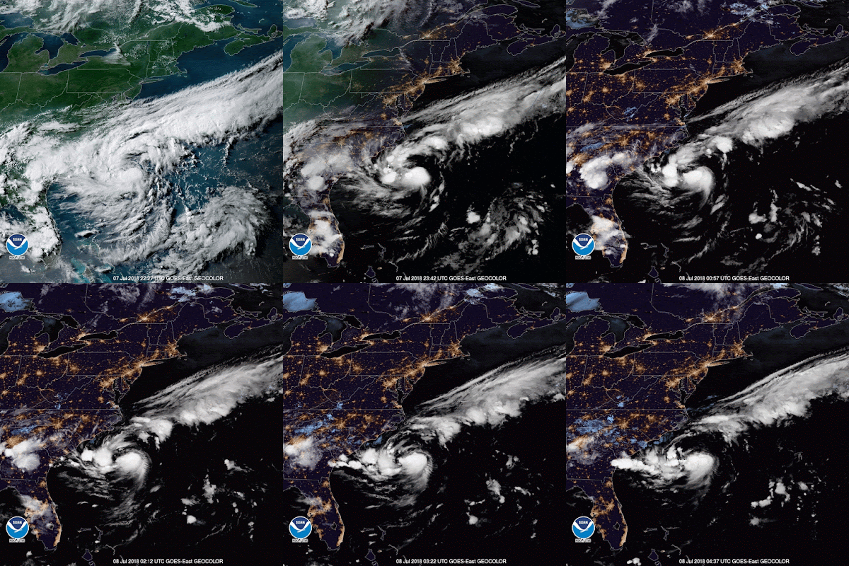
This little guy is still hanging out and doing a spot of fishing off the Carolinas at 32.9N, 75.1W. It must be a good spot because he's heading absolutely no-where. :-) 

Although he is officially a Tropical Depression, I think he is already a Tropical Storm because there is good circulation in the entire lower half of the troposphere (currently his circulation is better developed than Tropical Storm Beryl...shh... don't tell her that). He is definitely not a hurricane at the moment because there is no circulation in the upper troposphere. A plane is flying through the system tonight, so I fully expect to see him named once they get that data. The satellite image also shows a storm with a good 'outflow' (that serrated edge you can see on the east side): 

The forecast has him hanging out for the next couple of days, and then heading northeast:
I'll go with the NHC on this one, as for me, it is tricky to see where he'll go because he is stationary and the pressure around him will change. 

He is also over an area of warm surface waters with the upper 75-100m warmer than 26.5 deg C so he could intensify. The forecast is that he will be a Hurricane by Tuesday. I'm not sure if this will materialize yet because at the moment I do see some wind shear to the east. However, until he moves, it's a little murky. 

That's it for now, but of course, more soon!
Toodles,
J.  

--------------------------------------
DISCLAIMER:
These remarks are just what I think/see regarding tropical storms (my storm blog). If you are making an evacuation decision, please heed your local emergency management and the National Hurricane Center's official forecast. This is not an official forecast.
--------------------------------------

Saturday, July 07, 2018

Hurricane Beryl and Tropical Depression 3: July 6, Update A

Not much time for dilly-dallying today, alas! So I'll jump right into the thick of things... 

Hurricane Beryl
She's still a solid little storm and was, not surprisingly, upgraded to a hurricane this morning. She is currently at 10.9N, 48.9W and heading W at 14mph. She's a fairly weak cat 1 storm at the moment with winds of 80mph (cat 1 range: 74 - 95mph) and a central pressure of 994mb. There is no eye, so I think this is a pretty good estimate of her wind speed. 

The forecast track is slightly south of where it was yesterday:
This is because of the high pressure to her north that I mentioned yesterday. I do see a little break developing in that high pressure but we'll know more about how strong that is tomorrow. For now, I think she'll continue mostly westward(ish) (staying on the southern edge of that white cone) and then start moving in a WNW direction in a day or so. There is high pressure in her path ahead, so there is a chance that she may slow down a little tomorrow for a few hours (or she may move slightly southward, but I think slowing down is the more likely option).

She is still definitely a hurricane because there is circulation throughout the entire troposphere and she is passing over an area of water where the upper ~100m is warmer than 26.5 deg C - this will keep her happy and fed until she gets into the Caribbean. However, as she moves into the Caribbean, she will also move into an area of higher wind shear so we should start to see a small decrease in intensity as she gets closer to the Lesser Antilles and into the Caribbean. 

Atlantic Blob
This is now Tropical Depression #3, currently centered at 32.6N, 74.1W, just off the coast of the Carolinas. A Tropical Depression is a closed circulation with winds of over 17mph. TD3 currently has winds of 30mph - when they reach 39mph, he'll get a name and become an official Tropical Storm (Chris). I think he is already a Tropical Storm - there is very good circulation in the lower troposphere, and also in the mid-troposphere which is a sign of a Tropical Storm. 

There isn't much to stop him from continuing to develop at the moment - there is no wind shear to speak of, and he is hanging out over water where the sea surface is around 29 deg C, with the upper 50-100m warmer than 26.5 deg C. The only minor blot on his landscape is some dry air to the north, but I don't think it's enough to stop us from seeing Tropical Storm Chris pop in and say hello to the fishes in the Atlantic his weekend.

More tomorrow! And it's a weekend, so you may even get a fun Science or Technical Alert! :-) 

Ciao for now,
J.   

--------------------------------------
DISCLAIMER:
These remarks are just what I think/see regarding tropical storms (my storm blog). If you are making an evacuation decision, please heed your local emergency management and the National Hurricane Center's official forecast. This is not an official forecast.
--------------------------------------

Friday, July 06, 2018

Natural Disaster Prediction XPRIZE, TS Beryl and the Atlantic Blob: July 5, Update A

Botherations! I knew I should have written about the Natural Disaster Prediction XPRIZE Design Challenge yesterday and now Mama Nature has forced my hand with a pesky storm or two out there (for demonstration purposes). Guess it's time to pour another glass of wine and off we go.

Before we get to our delightful TS Beryl and friend, I have to ask you, my intelligent, witty, beautiful, smart pals, for your help! I want a Natural Disaster Prediction XPRIZE that would greatly reduce loss of life and economic damage from tropical storms (hurricanes, typhoons, cyclones) and earthquakes around the world. Wouldn't it be wonderful if you knew, 2 weeks in advance, the exact(ish) landfall location and intensity of a storm so you have oodles of time to get ready (and I can sit back and relax and eat bonbons all day ;-))? And living in Los Angeles, also on my 'small' wish-list - I'd jolly well like to know when an earthquake is going to happen with enough warning time to get to a safe place. Well at XPRIZE we are working on this and I'd humbly like to request your help.  

You can ALL help in one (or two) of two ways: 
1. Have a cup of tea and then submit a Natural Disaster Prediction XPRIZE prize design - participants can win prizes valued up to $100k (including being flown to LA and XPRIZE HQ and meeting me -- ok, ok, don't let that be a deterrent, I can hide if you are here! ;-)). We have launched a HeroX Visioneers Design Challenge for Natural Disasters, to ask the intelligent people of the world (i.e. YOU) to help us design a prize that will ultimately result in a solution to help all of us who live in tropical storm or earthquake zones (about 80% of the global population)! If you have an idea, please click on the HeroX link above and find out more. If you think you don't know how to design a prize, that's not a problem - you can watch this helpful video: Peter Diamandis' (Founder and CEO of XPRIZE) Master Class on Prize Design. We got to change the world... so I'm not blogging forever! ;-) Deadline to submit is 23 July.
(Image credit: animal-space.net)

2. Have a cup of coffee or glass of wine and share the link to the Natural Disaster Prediction XPRIZE Design Challenge and encourage your friends to enter. If you could email it, tweet it, facebook post-share it, LinkedIn it, pininterest it, youtube it, instagram it, snapchat it, periscope it, vine it, er... and whatever else the cool kids are using these days, that would be magical!

Right, oh yes, the pesky storms and another glass-of-wine-o-clock...

Tropical Storm Beryl
She has such a solid and respectable name, so how could she be anything but? She was named today and is currently at 10.4N, 44W, heading W at a decent 14 mph. She is already a mid-to-strong sized Tropical Storm with winds officially at 65mph (TS range: 39-73mph) and central pressure estimated to be 999mb. However she is a little thing, as you can see in this very cool but rather useless satellite image: 

The forecast is for her to become a hurricane by tomorrow evening, and I think this is quite likely - I think she's almost there because the circulation is pretty good in the lower half of the troposphere, and she already has some circulation in the upper levels of the troposphere - a sign of a hurricane. The track has her moving W and then WNW through the weekend: 
At the moment I think she will stay a little more south than this track is showing because there is a high pressure ridge to her north. We'll see if this changes tomorrow. 

Atlantic Blob
There is another crayon marking on the NHC map:

This blob has some low-level circulation, but not much higher up so he's not yet a Tropical Storm. Worth keeping an eye on as I think he's going to be moving closer to the US east coast, but nothing more than a blob (technical term! ;-)) at the moment. If he does develop, we'll call him Chris shall we? 

More on Beryl tomorrow!

Toodle pip!
J. 

--------------------------------------
DISCLAIMER:
These remarks are just what I think/see regarding tropical storms (my storm blog). If you are making an evacuation decision, please heed your local emergency management and the National Hurricane Center's official forecast. This is not an official forecast.
--------------------------------------