Sunday, June 07, 2020

TS Cristobal: June 6, Update A

In this day and age, a tinsy bit of good news for those of you in Louisiana and the northern-central Gulf watching TS Cristobal.

Today was the day when we knew we'd find out whether the dry air in the western Gulf would keep Cristobal in check, or whether crossing the deeper warm water in the Gulf would give him the strength to grow. Well... it looks like the dry air is winning that particular argument! Hurray!

He is currently at 26.2N, 90.2W, heading N at a respectable tropical storm speed of 12 mph:

Winds are 50mph, central pressure is 993mb, which makes him currently a weak-to-mid level storm (TS range: 39-74mph). 

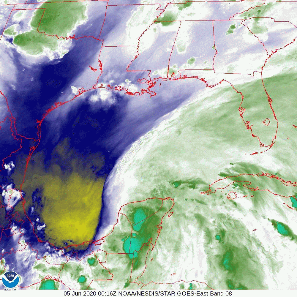
As a reminder, the patch of really warm deep water is what he has been crossing today, and is shown by the yellow bit in the middle of the Gulf in this image: 

We can actually see the impact that crossing has on him in the this satellite imagery, which shows that the convection has increased close to the center of circulation (the part that is over the deeper warmer water): 

You can also see the strong convection on the eastern side of the Gulf - over Florida. Technology is so great, that even though I live in Los Angeles, my phone told me that there was a tornado warning in Pinellas County in Florida today... I did see a video of a large tornado/waterspout near Orlando today.

For TS Cristobal's overall development, the dry air has been just too much and is inhibiting him from becoming something bigger: 

After he has crossed that patch of warm and deep water, it doesn't look like he'll intensify too much more, so maximum winds of around 60mph is probably about right. 

But he is going to make landfall to the west of the Mississippi delta, which means he will be pushing water upstream, so be prepared for some storm surge. 

<Technical Alert!> If you want to see the winds and other data as he moves into the northern Gulf, you can check out the Gulf of Mexico Coastal Ocean Observing System (GCOOS) data portal website - this includes moorings and platforms which are measuring real-time data. This Coastal Ocean Observing System is one of 11 around the US - all great resources for data offshore! <End Technical Alert!>

I clicked on a mooring in the middle of the Gulf (just north of the text 'Gulf of Mexico') which shows that the maximum winds at that location were 17 meters/second, which is 38mph - so not quite Tropical Storm winds at that particular location (alas, I don't think there is an easy toggle to make it into mph, but just multiply the m/s by ~2 to get the mph... or use google :-)) and we can see that the storm has just passed by because the pressure dropped and is now rising again: 


<Technical Alert!> And to check storm surge, I go to NOAA's Tides & Currents website: https://tidesandcurrents.noaa.gov/. Click on the state you are interested in, and then the area within that state that you want to see the storm surge for. You will see a number of 'pins' - if you hover over one, it will give you the location of the tide gauge. Click on that, and in the bottom left of the pop-up window, you will see a 'plot data' box. Click on that, and it will show you the data - depending on where you chose, you can see the predicted water level for the time of day, and the actual water level. The difference between these two is the storm surge. These plots may also include wind speed, water temperature, air temperature, and air pressure. Lots of useful data! &lt'End Technical Alert!>

I chose to zoom in on New Canal Station in Louisiana - a little way up the Mississippi river, near New Orleans, which is showing water levels of 1.77 ft above expected water levels:
&lt!Jargon Alert!> You may notice that there is a number at the top of this figure - 2.29ft above MLLW. MLLW stands for Mean Low Level Water - this is the lower of the two tides per day at this location, averaged over a 19 year time period. So, for our practical purposes and for anyone who lives in an area, it's not very user-friendly. This is why I prefer to compare the predicted level with the actual level, and in this case it is 1.77 ft. And don't even get me started on the sea level benchmarks that various data are compared against or presented against - it's all over the place! <End Jargon Alert!>

Well, I think that's it for today... must be a weekend. Two Technical Alerts and one Jargon Alert! You guys are SO lucky. ;-)

I'll pop back in tomorrow - when this one will make landfall. 

Be safe out there - listen to your local emergency managers because each area is different! 

Oh, and remember, for all Tropical Storms - hide from the wind, run from the water. This means that if you can shelter safely and you aren't in a flood zone, then stay in place. If you are in a flood zone, then get out. Water causes the most fatalities in tropical storms. 

Oh, and remember to eat the ice cream first in case the power does go out.... 

Ciao for now!
J.

Twitter: jyovianstorm
--------------------------------------
DISCLAIMER:
These remarks are just what I think/see regarding tropical storms - not the opinion of any organization I represent. If you are making an evacuation decision, please heed your local emergency management and the National Hurricane Center's official forecast and local weather service announcements. This is not an official forecast. If I "run away, run away" (Monty Python), I'll let you know. 
--------------------------------------

Saturday, June 06, 2020

Tropical Storm Cristobal: June 5, Update A

Another weekend, another storm!

TS Cristobal is currently at 22.7N, 90.1W, heading N at a pretty decent 14mph. The track forecast cone of uncertainty is quite narrow, which means that he is heading for Louisiana and the Mississippi Delta/New Orleans part of the world:
It's too soon to say exactly which side of the delta the center will go. A Tropical Storm in the northern hemisphere spins anti-clockwise. So, if the center falls to the left side of the cone - to the west of the delta - it will push water upstream and towards New Orleans and there is a possibility of flooding. If it is to the right side - to the east of the delta - then there will be less flooding. As the storm approaches the coast, water will get pushed towards land and up the river. 

There is good circulation throughout the lower half of the troposphere, so he's definitely a Tropical Storm. You can also see some nice circulation in the satellite imagery:


Isn't he a big guy? Spanning the entire Gulf from top to bottom! 

He is currently a weak Tropical Storm with winds of 45 mph, central pressure of 998mb (TS range: 39-74mph). The NHC forecast calls for a mid-level Tropical Storm with maximum winds reaching no more than 60mph over the next couple of days - starting tomorrow night and into Sunday morning. Then they think he will weaken before landfall, so at landfall he will be a weak storm with winds of 50mph. I'm not 100% sold on this - I think there's a chance that he will be stronger as he moves over that area of deep warm water I showed yesterday, so I wouldn't be surprised if he is strong Tropical Storm with winds closer to 70mph as he moves into the northern Gulf. 

But I can see why they think he won't develop too much - there is some wind shear and some dry air, which is holding his convection in check. This is why it's easy to see his center of circulation. There is more light grey clouds in the above satellite image instead of areas of heavy convection around the center. You can see the dry air being entrained into him in the water vapor imagery:

We'll see what happens tomorrow as he passes over that area of warm water - it'll be a tussle between the atmosphere and the ocean! 

It's Friday, and the end of another week of zoom meetings... 


I reckon that's it for today! 
Ciao,
J.

Twitter: jyovianstorm
--------------------------------------
DISCLAIMER:
These remarks are just what I think/see regarding tropical storms - not the opinion of any organization I represent. If you are making an evacuation decision, please heed your local emergency management and the National Hurricane Center's official forecast and local weather service announcements. This is not an official forecast. If I "run away, run away" (Monty Python), I'll let you know. 
--------------------------------------

Friday, June 05, 2020

Tropical Depression Cristobal: June 4, Update A

"Bit of a busy day. Distressingly little time for sloth or idleness!" (An Ideal Husband)

Hmm, so things are looking good at the moment, but if you are in the northern Gulf, it's a tad complicated, but I'd get ready for some wet and windy weather! 

In chronological order... Cristobal is now a Tropical Depression with winds of 35mph, central pressure 1000mb. He is at 17.8N, 90.4W, heading E at as fast as a running turtle, at 3mph. He is expected to turn north tonight. It looks like he made slightly more of an inroad into Mexico than expected, which is good because he will be weaker when he re-enters the Gulf tomorrow evening:

The other jolly news is that his circulation has deteriorated. It is still there, but it looks more elongated and like a low pressure trough than a tropical storm, which is a step in the right direction and I agree on the TD status.

The worst of the rains have been over Belize, parts of Guatemala, and the Yucatan peninsula, with a band of rain drops and kittens being blown across to Florida

Now... tomorrow evening (Friday night), he will emerge back into the Gulf. What we are watching for is how much of a hit does he take before getting back into the Gulf. If he makes it out of Mexico somewhat intact (winds of 35 mph), then the track the NHC have forecast seems about right and he will head towards the central northern Gulf - I don't have the detailed pressure data to think otherwise. 

The next question is how strong is he going to get? As I mentioned yesterday, once he gets into the Gulf, we will see the competing forces of The Atmosphere (strong wind shear will inhibit him) vs. The Ocean (warm seas will feed him). You can already see the wind shear in action in the satellite imagery - that's why the clouds are streaming gaily off to the northeast and over Florida. One more factor that will keep him in check in 'The Atmosphere' is a region of dry air to his west (the yellow area), which you can see in this satellite image of water vapor: 


I've seen dry air knock the wind out of fully grown up hurricanes (all puns always intended ;-)), so this dry air is a good thing. 

However, in the 'The Ocean' camp, sea surface temperatures across the entire Gulf are currently warmer than 26.5 deg C (warm enough for a storm buffet), with waters warmer than 27 deg C in the southern and middle parts of the Gulf of Mexico. But, adding to that, it looks like the Loop Current (see this post for the Science Alert! on the Loop Current) (or a Loop Current eddy) is in the middle of the Gulf, pretty much in his path. This image showing the depth of waters that are warmer than 26 deg C (from NOAA/AOML):

That patch of yellow - that's where waters are warmer than 26 deg C over the upper ~100m of the water column. He will be over that sometime around Saturday night if he is on the forecast track. So, if he is still intact from the wind and dry air by the time he gets there, I expect to see some strengthening as he crosses that part of the Gulf. Currently, the NHC forecast is that he will have winds of around 50-60mph on Saturday night... I think he may be stronger if he crosses that patch (and if he emerges from Mexico with winds already at 35mph). 

As I said, the first thing is to see how much he weakens tomorrow as he crosses Mexico. But may I just say, what a mess! Mexico has a very high rate of Covid-19 cases already, so even if he is just a weak storm, it's not been a groovy situation.  

Eyes on you tomorrow, TD Cristobal! 

Toodle pip,
J.

Twitter: jyovianstorm
--------------------------------------
DISCLAIMER:
These remarks are just what I think/see regarding tropical storms - not the opinion of any organization I represent. If you are making an evacuation decision, please heed your local emergency management and the National Hurricane Center's official forecast and local weather service announcements. This is not an official forecast. If I "run away, run away" (Monty Python), I'll let you know. 
--------------------------------------

Thursday, June 04, 2020

TS Cristobal: June 3, Update A

A very busy day yesterday, but it's just as well for everyone that you didn't have my loopy ramblings because the news and events were truly loopy enough!

As expected, TD 3 became Tropical Storm Cristobal yesterday afternoon and made landfall in Mexico this morning about 20 miles west of the town of Cuidad del Carmen, in the state of Campeche. He brought some wind at landfall - winds were those of a mid-level Tropical Storm at 60mph (TS range: 39 -73mph) but he has weakened since then and currently has winds of 45mph, central pressure 995mb.

However, the bigger issue was the rain. Alas, he has been hanging out near Cuidad del Carmen all day - he is just south of the town - and is stationary, so although not a big storm, that entire part of the world has had a lot of rain for well over a day, which has resulted in flooding. His center is at 18.3N, 91.8W. 

He is expected to get his walking boots back on and start moving overnight, heading southeastward tomorrow before turning north on Friday...

You can see how much rain there was with this storm across parts of Mexico and central America in the satellite imagery: 

The dark red areas are really heavy thunderstorms - the sort that can spawn tornadoes. 

Cristobal is definitely a Tropical Storm, and may be a little stronger than the NHC give him credit for. The circulation is very strong throughout the entire troposphere (ooh...  jargon... how exciting!! :-)), which means that if he wasn't over land, I think he would actually be closer to hurricane strength. Fortunately for all, he is over land.

<Science Alert!> The Troposphere: Our atmosphere is divided into layers - like a delicious trifle or seven-layer dip. In each layer the air temperature either increases with height or decreases with height. The troposphere is one of these layers. It is the lowest layer of our atmosphere and extends up from the earth (ground zero if you like) to about 15-16km in the equatorial regions, and to about 8km in the polar regions of the planet. This is the layer of the atmosphere we live and breathe in. All our 'weather' essentially occurs in the troposphere. The troposphere is defined by decreasing air temperature with increasing height. You would know this if you climbed a mountain. Or the easier option, of course, is to just look at pictures of mountains and see the snow at the top (known as the ‘Flat Florida Option’ ;-)). The top of the troposphere is called the tropopause. Strong tropical storms have clouds that reach as high as the tropopause - and in a few very strong cases, they can extend even higher into the next layer up - into the stratosphere, which is the layer of the atmosphere above the troposphere. The stratosphere is defined by air temperature increasing with height. The ozone hole is in the stratosphere. The top of the stratosphere is around 50km height and is marked by the stratopause. And the layer above that is mesosphere, where air temperature decreases with height again until the mesopause. Above that is the thermosphere, then the exosphere... and then we get to space.<End Science Alert!>

A Science Alert! followed immediately by a Technical Alert! How rare is that?!? ;-)

<Technical Alert!> It's really useful to know that temperatures decrease with increasing height in the troposphere. This gives us a clue about how strong a storm and it’s convection (rain, thunder etc.) is from the satellite images. The satellite imagery above is the infrared imagery and shows the temperature at the tops of the clouds. Higher cloud tops means a more turbulent atmosphere and stronger convection, but it also means colder cloud top temperatures. The red areas are the coldest cloud tops and they correspond to very heavy rain, strong winds, a lot of thunder, tornadoes… basically everything and the kitchen sink. Orange areas are less strong – thundery weather, strong winds, heavy rain. Yellow would be strong winds and rain, green is mostly rain with some wind, and then it gets to light rain/just cloudy where we see blue and gray.<End Technical Alert!>

Although the forecast calls for TS Critobal to weaken tomorrow and become a tropical depression again (because he is over land), until his circulation decreases he will retain his structure - I can see why the NHC think he will reform when he emerges back into the Gulf. 

The longer he stays over land, the weaker he will be of course. At the moment there are two competing things that will come into play once he is over water - the water is really warm in that part of the Gulf, which means he'll get stronger, but there is also strong wind shear, which will inhibit his development. 

The track will depend on how strong he is and when in the next two days he actually gets moving over water, so I will look into that tomorrow. Those of you in the northern Gulf states should be ready for a Tropical Storm anyway I reckon.

That's it for the Gulf. Meanwhile, in India, cat 1 level Tropical Cyclone Nisarga hit near Mumbai today, definitely causing some additional troubles on top of the pandemic! 

I'll be back tomorrow. 

Stay safe, be well!
Ciao,
J. 

Twitter: jyovianstorm
--------------------------------------
DISCLAIMER:
These remarks are just what I think/see regarding tropical storms - not the opinion of any organization I represent. If you are making an evacuation decision, please heed your local emergency management and the National Hurricane Center's official forecast and local weather service announcements. This is not an official forecast. If I "run away, run away" (Monty Python), I'll let you know. 
--------------------------------------

Tuesday, June 02, 2020

The 'Official' Start of the 2020 Atlantic Hurricane Season: June 1

Greetings and Salutations my friends! Welcome to the official start of the 2020 Atlantic Hurricane season! I don't think there's going to be enough ice cream, cheese, wine, tea, or lychee martinis to cover this year. Still, I'm glad we got through the quiet half of the year....  

Mother Nature woke up a little early with Tropical Storm Arthur, a genuine storm, in mid-May. Then she tried to sneak in Tropical Storm Bertha, a non-genuine storm, who really shouldn't have been named in my opinion because she wasn't a prim and proper tropical storm at all. But, as we've seen in the past, if the forecast is for a busy season, that's what it magically will be!

So, what are the predictions for this year anyway? In keeping with the overall theme for 2020, it looks like everyone is expecting a busier than usual season: 

Tropical Storm Risk (prediction date: 28 May): 17 named storms, 8 hurricanes, 3 major hurricanes.

Colorado State University (prediction date: 14 May): 16 named storms, 8 hurricanes, 4 major hurricanes.

UK Met Office (prediction date: 20 May): 13 named storms, 7 hurricanes, 3 major hurricanes.

NOAA (prediction date: 21 May): 13-19 named storms, 6-10 hurricanes, 3-6 major hurricanes. 

The 70-year long-term average number of named tropical storms is 12, the average number of hurricanes per year is 6, and the number of major hurricanes (category 3 or higher) is 3. 

I suppose looking at a wine glass half full (which clearly means it's almost time for a refill!), two of the named storms are already off the list, and it looks like a third one is brewing.

Tropical Depression Three is hanging out in the Gulf of Mexico, in the Bay of Campeche:

Winds are 30mph, so it's not yet a TS (winds have to be 39 mph for it to be a Tropical storm), central pressure is 1005mb. They think it will be named tomorrow - the next name on the list is TS Cristobal. He's not very strong, but will bring some rain over Mexico. More about that tomorrow. 

Now, back to the start of the season stuff... are you prepared? The usual hurricane supplies should include water, wine, ice cream, a good book to read, wine, some candles, ice cream, a radio for mood, batteries, some more wine, mosquito repellent, and lots and lots of cans of lychees, gin, and lychee liquor for the martinis. A 2020 special edition update: face masks, hand sanitizer, wipes, and ear plugs for the emergence of billions of cicadas that takes place once every 17 years (yes, of course 2020 is that year) in parts of the US! 

Over the last year a few more very intelligent and good-looking readers joined me (current hits on the website > 270,000) so if this is your first start-of-the-season post, here are my top 10 notes about this blog. Have a quick read and if you think this is going to be too boring for you, it is summer time after all so you can always watch the grass grow instead. ;-)

Top 10 things to note about this blog:

1. These updates are about fun, forecasting, and education... and tropical storms (and whatever else pops into my head that may, with some imagination and possibly after a glass or two of wine (or lychee martinis), fit those three words). It is just what I think.

2. I have a British sense of humoUr... you have been warned.

3. This is my hobby - sometimes you'll get one update a day, sometime four. If you are really lucky, you won't get any. If you wish to pay me to write, let me know and I'll send out updates as frequently as you like.

4. I hope you like Monty Python, Eddie Izzard, The IT Crowd. And other Funny Stuff.

5. If you have any questions (preferably about tropical storms), please ask. I will be happy to make up the answers for you. I can also cut and paste from previous entries (I’m very talented) so if I say something or use some "scientific jargon" (always thrilling!), please ask me about it.

6. I often write tongue-in-cheek, which sometimes hurts my cheek but what can you do? Gentle sarcasm, irony, and puns are all perfectly acceptable forms of communication. Unfortunately, they don't always translate in writing so please don't be offended - like Planet Earth, I'm "Mostly Harmless" (Douglas Adams). Have a piece of chocolate or a soothing cup of tea instead.

7. I'm sure every cloud in the Atlantic is exciting to some but, unless I'm bored, I'll usually write about those that I think are important.

8. Despite what you may have heard, I am not always right. But then neither is anyone else. Forecasting is complicated. Sometimes the crystal ball gets smudges and you are all out of Windex to clean it and the store is closed. So PLEASE pay attention to the National Hurricane Center, National Weather Service and your Emergency Managers - especially when a storm is looming because they have the most up-to-date information!!

9. I confess I am a twit. I am on twitter (@jyovianstorm). Twitter is cool sometimes. Just like bow-ties are cool (Dr. Who) sometimes. I will post these updates on Twitter, but I’ll also tweet about storms in other basins, my job, my movie, other people’s jobs, other people's movies, cool science, goofy things etc. so if you want to catch up between updates, that’s the place to lurk.

10. I will refer to ice cream, wine, cheese, cups of tea, and lychee martinis fairly frequently. To preemptively answer your questions, I do eat and drink other things for a balanced diet. For example, prawn cocktail crisps, fruit & nut chocolate, water.

That's more-or-less it from curfew in LA for tonight. I hope that the last few days will bring about meaningful changes! 

Ciao for now,
J. 

p.s. if you fancy a 15 minutes short sci-fi break from the news, the movie I produced, Hashtag, is finally available on line!

Twitter: jyovianstorm
--------------------------------------
DISCLAIMER:
These remarks are just what I think/see regarding tropical storms - not the opinion of any organization I represent. If you are making an evacuation decision, please heed your local emergency management and the National Hurricane Center's official forecast and local weather service announcements. This is not an official forecast. If I "run away, run away" (Monty Python), I'll let you know. 
--------------------------------------