Saturday, October 01, 2022

September 30, Update A: Post-Tropical Cyclone Ian

It's the weekend after one long week, so I'm sure you'll be happy to know that this will be my last update on what is now Post-Tropical Storm Ian. 

He made his final landfall just after 2pm local time near Georgetown, South Carolina, 55 miles NE of Charleston, as a cat 1 level storm with winds of 85 mph, central pressure 977mb. He is now at 35.3N, 79.5W and heading north at 15mph. Winds are around 50mph, central pressure of 994mb, which makes him the equivalent of a weak Tropical Storm. Now he has moved away from the Gulf Stream there isn't much left in this system as far as convection goes:


He certainly caused a lot of damage and sadly, multiple deaths, in Cuba and Florida. But this is the last time we will have a tropical storm called Ian.  

Atlantic tropical cyclone names are re-used on a 6 year cycle until they cause so much destruction and loss of life that they are retired. Given the scale of devastation, the name 'Ian' will be retired from the list of Atlantic tropical cyclone names, so in 6 years, we'll have a different 'I' storm. 

As for what else is out there... there is a small Atlantic Blob not too far off the coast of Africa. We'll see how it develops, but for now, nothing much to write home about. 

The next storm name will be Karl.

Until then,

Toodle pip! 

J. 

Blogs archived at http://jyotikastorms.blogspot.com/

Twitter @JyovianStorm
--------------------------------------

DISCLAIMER:

These remarks are just what I think/see regarding tropical storms - not the opinion of any organization I represent. If you are making an evacuation decision, please heed your local emergency management and the National Hurricane Center's official forecast and local weather service announcements. This is not an official forecast. If I "run away, run away" (Monty Python), I'll let you know.


Friday, September 30, 2022

September 29, Update A: Hurricane Ian

Phew... this was a two glasses of wine evening! The good news is that the Tampa Bay area got off fairly lightly, but I'm sure you have all seen the destruction in the Ft. Myers area and other parts of the state with many areas still flooded, almost 2 million without power, and 14 deaths so far in Florida. This will be the last time we have a Hurricane Ian on the roster and in 6 years, it will be another name for 'I'. But, alas, Ian isn't quite over yet... 

He is now officially a mid-intensity cat 1 storm with winds of 85mph, central pressure 984mb (cat 1 range: 74-95mph):


His convection is not very strong though - in fact, what little we see in the satellite imagery above is because he is over the warm (and deep warm) waters of the Gulf Stream. This is an area where storms usually get stronger but there are three reasons he doesn't look as strong as we would expect. First, there is the wind shear which he's been experiencing for the last couple of days. This has resulted in his upper level circulation being offset from the lower level circulation so he is not very well vertically aligned. Second, there is an immense amount of dry air. The satellite imagery below is the water vapor from the mid-levels of the troposphere and the yellow areas are dry air:

And third, although he is officially a hurricane on the books, he is actually merging with a front which is really where he is getting that extra boost of energy (instead of from the ocean, which is where he would get it if he were truly a tropical storm). The lowest levels of the troposphere are already looking more like a front - the upper levels are still showing tropical storm circulation. This merging of a tropical storm and a front is what happened with Post-Tropical Storm Fiona as she reached Canada last week. 

For a hot minute before leaving Florida (just north of Cape Canaveral near New Smyrna Beach) he was officially downgraded to a Tropical Storm but promptly went back up to hurricane strength. I am not sure he really lost that hurricane intensity because his circulation remained fairly strong throughout the troposphere - even in the higher levels - which means he had a relatively good storm structure of the sort we see in hurricanes. 

He might get a little stronger before reaching land which looks like it will be the South Carolina coast (near the North Carolina border) tomorrow:


He is currently at 30.2N, 79.3W, heading NNE at 10mph. As expected, the track has shifted eastward all day and is now getting closer to a good estimate for landfall - better than this time yesterday... landfall may be near Myrtle Beach, although, if you are in Wilmington, NC, you may want to be ready for a bit of a breeze in addition to the rain you will get as I think he still has room to shift to the east.

The winds will be pushing water onto the coast north of the center, and off the coast south of the center. I would suggest you have a look at the sea level sensors along the coasts of Georgia and South Carolina, however that won't take long because it looks like there is only one in Georgia - in Savannah - and two in South Carolina - one in Charleston and one near Myrtle Beach. Water at Fernandina Beach in Florida is at around 2ft above normal, and Savannah is 1 ft above normal at the moment. 

Tomorrow, I hope I'll be saying that Hurricane Ian is over! In the meantime, for those of you in the Carolinas - listen to your emergency managers and be safe. 

Ciao,

J. 

Blogs archived at http://jyotikastorms.blogspot.com/

Twitter @JyovianStorm
--------------------------------------

DISCLAIMER:

These remarks are just what I think/see regarding tropical storms - not the opinion of any organization I represent. If you are making an evacuation decision, please heed your local emergency management and the National Hurricane Center's official forecast and local weather service announcements. This is not an official forecast. If I "run away, run away" (Monty Python), I'll let you know.

Wednesday, September 28, 2022

September 28, Update A: Hurricane Ian and the Atlantic Blobette

Oh dearie me. Ian is such a nice human being... but not such a nice storm. In Cuba, he wiped out power - not just on the western side but across the entire island (for the first time). 

Hurricane Ian

In Florida, he made landfall a few hours ago at Cayo Costa in the Sanibel/Captiva/Fort Meyers/Charlotte Harbor area of Florida and they are now experiencing what remains of his rougher weather as he passes by:


He officially made landfall at around noon local time as a cat 4 storm with winds just under 150mph, central pressure of 940 mb (cat 4 range: 131-156mph) - a big storm covering a lot of ground and bringing a load of rain to the Sunshine State. 

Winds are officially now 115mph, central pressure 960mb, which makes him a cat 3 storm (cat 3 range: 111-130mph). He is clearly not as robust looking as he was at landfall, which suggests a weaker storm - he still has an eye but he may even be a strong cat 2 at this point, but not too far off from his current cat 3 status. 

As expected, the storm surge has been incredibly high south of landfall. At Fort Myers, just south of where the center of the storm passed, at the location of the sensors, the water peaked at over 7 ft above normal:

Further the south, in Naples, it looks like the sensor station stopped working when the storm was close enough, but even then it got to over 6ft above normal:


And in Tampa Bay to the north of the center - at St. Pete (my old home) the water levels were, as expected (isn't physics great?!), over 5 ft below normal:


In case you didn't click on the link yesterday on how to look this up for yourself, I'm doing that very clever thing of copying and pasting my own writing here for you... 

<Technical Alert!> How to look up Storm Surge: Go to NOAA's website: tidesandcurrents (https://tidesandcurrents.noaa.gov/). If you click on this link, you will see an ugly cartoonish bad-suntan coloured map of the US (in shades of orange to represent the land - don't ask me why they picked this colour). Click on the state that you are interested in e.g. Florida. This will show you a much nicer colour map with a bunch of pins. These are the locations of the stations. You have to be careful though (if you are on a Mac especially) because the map is not static so you can accidentally scroll around and end up in the middle of the Atlantic, and will have to zoom out until the map you want re-appears and then zoom back in. A bit fiddly, I have to say. 

You can either locate the nearest station by entering the area you are interested in, or zoom into the map. Click on that station, and in the lower left is a button that says 'plot'. Click that on and it will show you a plot of the expected water level (in red) and the actual measured water level (in blue). 

By scrolling your mouse over the plot, the numbers appear showing the actual values (and then you have to do some complicated maths to get to the difference between the two - I know... get that calculator out! ;-)). 

If you want to see the corresponding winds, air pressure and other handy-dandy data, you can scroll down. <End Technical Alert!> 

So here, for example, is the pressure field at Ft. Myers which clearly shows what the pressure was when the storm was closest to this location...


Interestingly, the eye of the storm passed very close to this area and the official low pressure of 937mb is quite a bit lower than the in-situ measurement here, which suggests that at this location at least the storm was not a cat 4. 

And if you want to have a look at data offshore, check out the University of South Florida College of Marine Science COMPS network (these are the moorings I got my PhD data from a <ahem> couple <ahem> of years ago ;-)), which is part of the Southeast Coastal Ocean Observing System and the Gulf of Mexico Coastal Ocean Observing System:


The air pressure at the mooring closest to the Hurricane Ian (C10) - just to the northwest of the track - showed a low pressure of 993mb with maximum winds of around 60mph, so that mooring was definitely under a Tropical Storm. To understand the storm and get a better idea of what it is like before making landfall, we need these good observations off shore! 

He is currently at 27.2N, 81.7W, heading NNE at 8mph and is expected to leave Florida tomorrow as a Tropical Storm and head into southern South Carolina. Tricky to tell, but I think he is still going to head more to the eastern side of that cone of uncertainty, so again - get ready if you are in that cone.


He may be a bit stronger than a Tropical Storm by the time he leaves Florida, but we'll see. He has very good circulation in the upper troposphere and is also interacting with the warm and deep waters of the Gulf Stream as he exits Florida and heads north, so at the very least, he'll continue to bring rain, rain, and more rain. 

I've had a few reports along the west coast of Florida. Here's a video (with sound) from a couple of hours ago from Chas S. in St. Pete - it looks like a lovely, blustery day:

I also heard about a downed power line sparking on the ground... as you go out after the storm, be careful of downed power lines in puddles please. Electricity + Water = Not Good. 

Tomorrow we'll have a clearer idea of the impact on the west coast of Florida. 

Atlantic Blobette (Tropical Depression 11)

And it's not quite over yet... there's another blobette out there:

They expect her to become Tropical Storm Julia tomorrow. She doesn't have much circulation yet though - not even in the middle levels of the troposphere so we'll see if she is robust enough to be named. But she's another shortie (like me ;-)) and will stay out in the Atlantic, so this is going to be my only mention of her. 

Listen to your emergency managers. Be safe! Eat Jaffa Cakes. 

Toodle pip,
J. 

Blogs archived at http://jyotikastorms.blogspot.com/

Twitter @JyovianStorm
--------------------------------------

DISCLAIMER:

These remarks are just what I think/see regarding tropical storms - not the opinion of any organization I represent. If you are making an evacuation decision, please heed your local emergency management and the National Hurricane Center's official forecast and local weather service announcements. This is not an official forecast. If I "run away, run away" (Monty Python), I'll let you know.

Tuesday, September 27, 2022

September 27, Update A: Hurricane Ian

It's getting a bit hot out there, so I've got my ice cream and I'm ready to check in on Hurricane Ian...

Track: I, along with a few hundred thousand of my closest friends, have been watching Ian's track shifting to the east (and hence south) all day. He is currently at 24.4N, 83W, heading NNE at 10mph - making that turn towards the east sooner than officially forecast yesterday. This means he will be making landfall tomorrow, not Thursday:


That change in track also means his intensity will be a little different than forecast but more on that later. After landfall, the pressure fields are set up to push him across the state in the general NE direction we see in the official forecast - emerging maybe a little south of where the forecast is at the moment (perhaps the Daytona Beach/New Smyrna Beach area) - but still within that cone of uncertainty so please keep an eye on the entire cone! 

Intensity: He is currently a mid-size cat 3 storm with winds of 120mph, central pressure 947mb (111-129mph). I agree with this estimate. Given that his track has shifted, his intensity will be different as well. There are a couple of things that are working to keep him a little in check. First, he won't be over that deep warm water as much as previously forecast and second, the wind shear has really picked up which you can see in the clouds that are streaming off to the northeast. The eye is already looking worse actually...


And just to show you how far the clouds are streaming off Ian due to wind shear, here's the amazing satellite imagery of half of our planet: 


Yes, you guys in Newfoundland have clouds from Hurricane Ian as well! 

The circulation is still strong throughout the troposphere, but the lower levels are being impacted by that wind shear. If Ian continues to deteriorate, he may be a weak cat 2/strong cat 1 on landfall. Regardless of what he is at landfall, because Florida is a flat and soggy state with Lake Okeechobee in the middle and the Everglades to the south, he will only go down one level by the time he crosses the state - so if he's a cat 2 at landfall, he will be close to a cat 1 on the other side. 

And despite the wind and intensity, at landfall there will still be storm surge...

<Science Alert!> Storm surge is water rising along the coastline as a storm approaches and makes landfall. How high the storm surge is depends on a number of factors: 

1. Storms are low pressure systems, which means that there is low atmospheric pressure. But obviously we don't have a "gap" between the air and the ocean (which are both fluids - one gas and one liquid), so the water 'rises' up to fill that 'gap' which is created by the low atmospheric pressure. So the stronger the storm is, the lower the central pressure, the greater the 'gap' for the water to rise to 'fill'. 

2. Storms are low pressure systems, so in the northern hemisphere they rotate in an anticlockwise direction.  This means generally water will be pushed onshore on the eastern side of the eye (depending on land orientation), and will be pushed off shore on the western side. Storm surge will be higher on the eastern side. Or in this case, on shore south of the eye and off shore north of the eye.

3. Speed of the storm. If a storm is moving quickly, then there is simply less time for water to get pushed onshore before the storm has swung by. Storm surge is greater for slower storms. 

4. Angle of storm approach to land. Depending on if a storm is approaching land directly or at an angle can affect the amount of storm surge because of the direction of the winds. Storms that are heading directly onto shore result in greater storm surge than those that are approaching it from an angle - skirting along the coastline. 

5. Shape of coastline (bays etc). Water can get piled into bays and upstream in estuaries of course. 

6. The depth of the seafloor just off the coast is important. For areas with a shallow seafloor, more water piles up compared to areas where the seafloor is deep just off the coast. 

<End Science Alert!>

To monitor storm surge, I use NOAA's tidesandcurrents website (instructions for this website are in the <Technical Alert!> in this post). At the moment, Key West is already seeing 2 ft above normal levels:


Naples, still to the north of the center, is actually slightly below normal:


And St. Pete levels, even farther north, are dropping as the storm gets closer:

And I know my friends are taking it seriously in Florida when the hurricane supplies move beyond water and wine... 


Be safe out there - listen to your local emergency managers!

Ciao,

J.

Blogs archived at http://jyotikastorms.blogspot.com/

Twitter @JyovianStorm
--------------------------------------

DISCLAIMER:

These remarks are just what I think/see regarding tropical storms - not the opinion of any organization I represent. If you are making an evacuation decision, please heed your local emergency management and the National Hurricane Center's official forecast and local weather service announcements. This is not an official forecast. If I "run away, run away" (Monty Python), I'll let you know.


Monday, September 26, 2022

September 26, Update A: Hurricane Ian

Time for a look at the game afoot with my afternoon cup of tea here.

Hurricane Ian. Are you ready? Got your ice cream stocked up?

Track: he is at 20.3N, 83.2W, heading NNW at 13mph. The track forecast did move to the east and is taking him to the west coast of Florida, close to the Tampa Bay area (and where this blog started in the first place, so I have a lot of peeps in that area, some of whom are evacuating I have heard): 

I can see why the track looks like it does - there is a high pressure building to the right of the track before it gets to Florida (remember, storms go clockwise around a high pressure system), which is why they think he will move a little more in the NNW direction before curving around it to the NNE. But, very crucially, where he makes landfall relative to Tampa Bay - north or south of the Bay - will make a huge difference. 

Why? That's because the storm is a low pressure system, so the winds are pushing water around it in a counterclockwise (anticlockwise) direction. If he lands to the south (corrected from earlier when I had north written here - thanks to Steve M. for catching this!), the water will mostly get pushed out of the Bay - or along the Pinellas County side for a short while. If he lands to the north of the Bay, the water is going to get pushed into Tampa Bay (and on shore along all bays and coastline to the south) - and along with the water from the rain, it will take a long time for the Bay to drain so the water can take a while to decrease. The same thing applies in Sarasota and other areas along the southwest coast of Florida.

For storms, remember - run from the water, hide from the winds. The greatest loss of life in a tropical cyclone is from water (storm surge, flooding etc), not from the winds. SO... if you are in an area that floods under normal rainfall, or if you are near a river bank, please evacuate sooner rather than later - I am sure your local emergency managers are saying the same thing. Otherwise, if this was a cat 4 or 5 storm, I would also evacuate if I could. 

I think he may move a little more the east than expected - meaning a landfall in the southern part of the cone of uncertainty (between - Tampa Bay and Naples) we will know more tomorrow of course. 

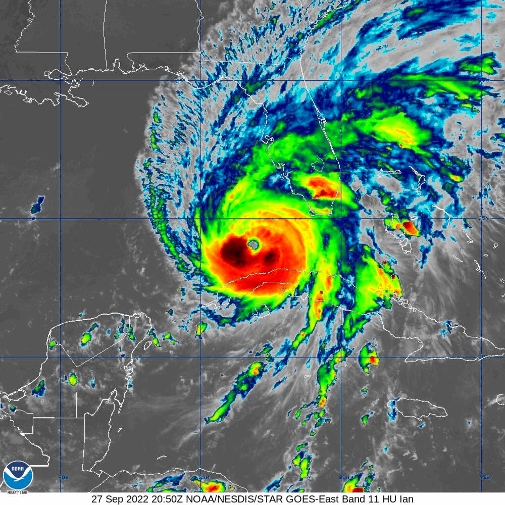
Itensity: He is now officially a mid-size cat 2 storm with winds of 100mph (Cat 2 range: 96-110mph), central pressure 972mb. I think he may be factionally weaker than this (maybe 95mph based on his satellite appearance) and I know they say rapid intensification, but I think he was a cat 1 yesterday so in my head it's not been so rapid. He is turning into a good looking storm:

And the convection has really picked up today so Cuba and part of South Florida and the Bahamas are already getting bunches of rain and thundery weather... 

But you will see that large parts of the storm are still in that green range - including around the center of circulation - which is why I think he may just about be a cat 2 storm. Also, interestingly, the strongest convection is to the south and diminishes in his northern flank - it hasn't yet fully wrapped around his center. This is partly because he is starting to interact with Cuba (which will help to keep his intensity down a bit) and partly because although the sea surface temperatures are warm, the warm water is really deepest on his southern side. 

For those of you who want to see the spinach he's been eating to make him stronger, this is for you...

<Science and Forecasting Alert!> The Loop Current (System)The Loop Current is part of an ocean current system that flows from the Caribbean into the Gulf of Mexico through the Yucatan Strait, and then out of the Gulf of Mexico through the Straits of Florida, and up the east coast of the US. How far it extends into the Gulf of Mexico varies from year to year and month to month. As this current flows around Florida, it changes name to become the Florida Current. Then as it flows up the east coast, it changes name again and is known as the Gulf Stream. It leaves the US east coast around North Carolina and flows across the north Atlantic to the UK. Why is this current system important for tropical storms? This current system is well known because it has the deepest warm waters, and is very fast flowing - but the current also has offspring that can also have deep warm waters (all these offspring are called Eddy by the way). The deep warm waters mean that tropical storms that pass over any part of this current system or over any warm water Eddies have a jolly good (British understatement) chance of becoming stronger. 

So, how can you see where these areas are? One of the places I look is buried within the vast network of websites that NOAA - the Office of Satellite and Product Operations has a site called Satellite Heat Content Suite (such a catchy name - made for a song lyric I'm sure! ;-)). I use the North Atlantic page: https://www.ospo.noaa.gov/Products/ocean/ohc_natl.html. If you click on this, you will see all sorts of maps. The two most useful for our purposes is the one on the top left - Sea Surface Temperature - which looks like this today: 


You can see that the waters where Ian is are over 29 deg C. The other most useful map (more so than the sea surface temperatures) is the depth of the 26 deg C Isotherm - third one down in the right column and that looks like this today:


From this, we can see that Ian has been passing over that area of orange just south of Cuba - this is where the upper 150-160m of water is warmer than 26 deg C! No wonder he picked up some convection. <End Science and Forecasting Alert>

Going forward, there is a possibility that he is not a major hurricane when he makes landfall in Cuba - by the time he is a cat 3 we should see the eye more clearly - actually, if he's a cat 2 with 100mph winds, we should see the eye appear once in a while and I don't see that in the visible imagery. If he doesn't make landfall in Cuba as a major storm, then crossing Cuba will knock him down a bit. However, as he emerges, he will be over warm deep water again (as you can see in the map above - depending on the path he takes, it may not be for long so he may not get quite as strong again. All the models are showing that he will get stronger on the other side of Cuba of course, but we will see. The thing I'll be looking for is that eye and how strong he is when he gets to Cuba.

Stay safe out there - get ready - listen to your local emergency managers - eat ice cream - drink wine - Don't Panic! - be good! 

Ciao for now,

J.

Blogs archived at http://jyotikastorms.blogspot.com/

Twitter @JyovianStorm
--------------------------------------

DISCLAIMER:

These remarks are just what I think/see regarding tropical storms - not the opinion of any organization I represent. If you are making an evacuation decision, please heed your local emergency management and the National Hurricane Center's official forecast and local weather service announcements. This is not an official forecast. If I "run away, run away" (Monty Python), I'll let you know.


Sunday, September 25, 2022

September 25, Update A: Tropical Storm Ian (mostly)

Tropical Storm Ian 

Jumping in first with Tropical Storm Ian who is in the Caribbean at 16.2N, 80.3W and heading WNW at 12mph. As expected, he has started to shift northward compared to his westward motion over the last couple of days however his track forecast after ~2 days is really, alas, still quite uncertain.


That high to his north has cleared up quite a bit now, so he may shift a little more to the east again, but 3-4 days is a lot time so he could go anywhere in that cone, not only where the center is at the moment.  

He is still officially a weak TS with winds of 45mph, central pressure 1003mb (TS range: 39-73mph). I think he may be a bit stronger than this - possibly a mid-level Tropical Storm with winds of around 55-60mph because there is good circulation in the lower half of the troposphere and it is also improving in the upper troposphere (which happens as a storm gets close to hurricane strength) - you can see his center very clearly in the visible satellite imagery: 

The heavier convection (rain and stuff) has increased a little since last night, but other than some clouds, it is still not fully wrapped around his center of circulation:


Although the sea surface temperature is warm (over 29 deg C) and water warmer than 26 deg C is in the upper 100m of the water column, it does look like there is some dry air in this system which is coming in from the northwest which is one factor keeping him in check. This is the satellite imagery of water vapor in the lower levels of the troposphere - the yellow areas are dry air. 


You can see from this that the water vapor is increasing near his center of circulation, but it was dry before that increase (shown by the purple parts). 
So, with increasing water vapor, warm ocean waters, and almost no wind shear, he will continue to intensify some more today as forecast (although I don't think it will be as rapid as forecast because I think he is already stronger than the official forecast).

Looking ahead, his intensity depends on the track he takes:

Eastern path/less intense storm possible: If he remains to the eastern side of that cone, he will pass over land (Cuba) and then only briefly over the deep warm waters of the Loop Current/Florida Current, so he won't intensify too much and may not even become a major hurricane (cat 3 or higher). 

Western path/more intense storm possible: On the other hand, if he stays on the western side of that cone of uncertainty, he may only just skim over Cuba and will spend longer over the deeper warm waters of the Loop Current which will give him a lot more energy to get more intense and he could become a major hurricane. 

However, in either case, when he does reach the northern Gulf, the water temperatures there are around 28 deg C, but that warm water doesn't extend very deep into the water (across the entire northern Gulf) - only the top ~40m or so are warmer than 26 deg C. The forecast also calls for an increase in wind shear by the time Ian gets into the northern Gulf, so at the moment it is unlikely that the storm will be a major one by the time he actually makes landfall in the US. 

Post-Tropical Storm Fiona

A quick note to wrap up on Post-Tropical Storm Fiona - Canada is assessing the quite extensive damage from Fiona which was because she was a merger of a tropical storm and a front, so there was a lot of energy in this storm. Not necessarily the tornadoes and crazy thunder/lighting you get in a strong hurricane, but she did bring some very strong winds because of that energy (with the highest measured wind gusts of ~111mph) which resulted in downed trees and power outages. She also had the lowest pressure for a storm reaching Canada, with a recorded low pressure of 931mb on land. Her storm surge was also substantial and washed houses out to sea - here's a tweet of one of many videos doing the rounds on the internet that shows the storm surge first hitting the coastline. I think this is one of the strongest storms Canada has seen in decades - if not a century! 

More later my peeps,

J.

Blogs archived at http://jyotikastorms.blogspot.com/

Twitter @JyovianStorm

--------------------------------------

DISCLAIMER:

These remarks are just what I think/see regarding tropical storms - not the opinion of any organization I represent. If you are making an evacuation decision, please heed your local emergency management and the National Hurricane Center's official forecast and local weather service announcements. This is not an official forecast. If I "run away, run away" (Monty Python), I'll let you know.

September 24, Update A: Tropical Storm Ian

Today it's all About A Boy called Ian, although there are a few other names still floating around:


But Fiona and Gaston are on the decline, and Hermine is now just a Tropical Depression, so that leaves...

Tropical Storm Ian

He is currently at 14.7N, 77.7W, heading W at 13mph. He continued on a more westward track than forecast yesterday because the high pressure to his north remained strong. I don't have good data on the pressure fields anymore but it looks like the high pressure to his north may be starting to weaken he may start to move a little towards the north soon. 

In case you are wondering why the NHC (who are using models) are sure he will make that WNW and then NW turn, despite him taking a more westward track than expected for today, let me tell you why... 

<Science Alert!> Storm tracks: In the northern hemisphere 'things' (technical jargon ;-)) tend to move clockwise around high pressure systems, and counter-clockwise around low pressure systems. For example, a tropical storm has low pressure in the center so winds (aka 'things') move counter-clockwise (or anticlockwise if you prefer) around a storm. Similarly, tropical storms (aka 'things') also move around larger pressure systems. There is generally a region of high pressure that likes to hang out over the Atlantic, sometimes called the Bermuda High or the Bermuda-Azores High. You can imagine it as a big clock face over the Atlantic, like this:

(Image credit: Moi!)

As storms cross the ocean, they move westward along the six o'clock region. As they turn WNW and NW they are moving from 6 to 9. Then they move N and NE, from 9 to 12. Of course, this imaginary clock face isn't nice and round, nor does it stay in the same place (otherwise forecasting the track would be easy peasy :-)). It's like a Dali clock face, with wiggly bits (more technical jargon ;-)) that are always moving:

Sometimes this high pressure stays out in the Atlantic and we don’t see many storms making landfall, and at other times the high pressure extends across the Caribbean and storms end up in Central America instead of turning north. In Ian's case, there is a high pressure to his north, which means he continued westward. However, as that weakens, he will start to move clockwise around that. 

The NHC track forecast is based on the output from a number of models, and these track models are all trying to predict the changes in the pressure fields around the world which is why they are all a little different - depending on how they do that prediction. The pressure field really is quite complicated - it's not only how it changes horizontally but also how it changes vertically that needs to be considered. To show you how complicated this is, here is a representation of the pressure field in the middle of the troposphere (around 5km above the surface of the Earth):

As you see, lots of squiggles that are all wiggling about at the same time! <End of Science Alert!>

As for his intensity, at the moment his winds are only 50mph, central pressure 1002 mb which means he is still a relatively weak Tropical Storm (TS range: 39-73mph). The two main factors for intensity at the moment are wind shear and water temperature (the air is fairly humid around him and he isn't near any land so those two aren't at play today). 

Water temperature: Ian is currently over the toasty waters of the Caribbean with sea surface temperatures over 29 deg C, however in an area where only the upper 50m of the water column is warmer than 26 deg C which is why his convection is not very strong - especially to the south of the circulation where the water is a little cooler. But soon he will be moving over an area where the upper 100m of the water column is warmer than 26 deg C and that will really help him to intensify tomorrow, and by Monday, he'll be over a region with sea surface temperatures warmer than 30 deg C with the upper 150m is warmer than 26 deg C - that is when he is expected to become a major hurricane.  

Wind Shear: He also hasn't intensified a lot today because of wind shear but this is decreasing and everything else is in favour of his intensification tomorrow. Until earlier today, his convection was not in the same location as the circulation, however that has now come into alignment... 

His circulation is pretty good in the lower half of the troposphere and I do now see some circulation in the upper levels of the troposphere now which suggests that he is already stronger than the 50mph winds would suggest. 

I agree with the NHC forecast that he will intensify tomorrow. They think he'll be a cat 1 storm by this time tomorrow and I think he may be a little faster than that and become a cat 1 storm a bit earlier in the day - but either way, he'll become a bit better looking tomorrow.   

Although the track at less than 5 days is really uncertain (3/4 of the State of Florida is currently in the Cone of Uncertainty), I know you will be ready in Florida and the northern Gulf coast... 

Ciao for now,

J. 

Blogs archived at http://jyotikastorms.blogspot.com/

Twitter @JyovianStorm
--------------------------------------

DISCLAIMER:

These remarks are just what I think/see regarding tropical storms - not the opinion of any organization I represent. If you are making an evacuation decision, please heed your local emergency management and the National Hurricane Center's official forecast and local weather service announcements. This is not an official forecast. If I "run away, run away" (Monty Python), I'll let you know.


Saturday, September 24, 2022

September 23, Update A: Post-Tropical Storm Fiona, Tropical Storms Gaston, Hermine, and Ian

I'm jumping right in with my customary Friday lychee martini in hand because there's a bunch of names on the menu today...


Post-Tropical Cyclone Fiona

She is at 44.5N, 60.8W, heading N at a roadrunner pace of 46 mph!! This forward speed is a clear indication that she is part of that front now and definitely not a tropical storm anymore, and the NHC have changed her designation to post-Tropical. Her wind speed is 105mph, central pressure is 933mb, which makes her a mid-size Cat 2 storm (cat 2 range: 96-110mph). She is going to head north and is expected to have Tropical Storm level winds by tomorrow:

There is a lot of wind shear and so her convection has not only decreased (because she is over colder water now) but it is also being pushed to her north and west: 


So Nova Scotia, Newfoundland, and beyond are getting (or have had) some bouts of heavy rain but mostly this will be a windy storm.  If it wasn't for that front she's got herself involved with, I don't think she would even have this much wind and would really be a weak cat 1 or Tropical Storm level system by now. 


Tropical Storm Gaston

Just a quick note on Gaston, who is behaving exactly as predicted. He is at 38.9N, 29.5W, heading SW at 8mph. He's in the Azores and hasn't changed too much since we last saw him - 60mph winds, central pressure of 999mb. There is almost no convection in him so he's a paler version of Fiona - just a very breezy weekend in the Azores. 


Tropical Storm Hermine

And gaining ground from behind, an Atlantic Blob that was identified as having potential when it was still over Africa has now overtaken our Caribbean Blobette of yesterday to become the new Tropical Storm Hermine (which now makes the Caribbean Blobette a Caribbean Blob called Ian :-)).

Hermine is at 19.4N, 20.8W heading N at 10mph. She's barely a Tropical Storm with winds officially at 40mph (TS range: 39-73mph), central pressure 1002mb. I think she's actually a bit stronger than this - she has good circulation in the lower half of the troposphere, and certainly has more convection (thundery weather) than Fiona and Gaston: 


But we will never know how strong she really is because we don't have planes or anything else that can get into the system that far east (just off the coast of Africa) and give us data from within the storm, so the official assessment of intensity is really just a rough estimate. This is a problem in assessing intensity for storms around the world actually - satellites are great, but they only get us so far and then we need other ways of getting in situ data. In the meantime, Mauritania and the Western Sahara region is getting quite a few buckets of rain and will continue to do so for the next few days:

She is scheduled to just head north and then fizzle out by Sunday, so this is my last update on Hermine (unless she does something a bit wonky). 

Tropical Storm Ian

This was our Blobette of yesterday. He is at 14.8N, 72W and is heading WNW at 12mph. He is also barely a Tropical Storm with winds of 40mph, central pressure 1005mb. The track has him heading to the general Florida region via a quite visit to the Cayman Islands and Cuba... 


I am not going to comment on the track for now - the NHC are very good at within 24 hours, but I don't have enough data yet to see what is beyond that. All I'll say is that the cone of uncertainty is covering most of Florida, so everyone should be getting ready. 

But intensity I can chat about. The Caribbean has a lot of warm water - the sea surface is warmer than 29 deg C and Ian is going over an area where the upper 125-150 m of water is warmer than 26 deg C, which means that the water he churns up is also warm enough to give him energy. This means that he has a lot of thundery and tornado-level convection, which we see from the infrared satellite imagery:


There is also a lot of moist air - not dry air- around him, so that will also allow him to get stronger. However, his circulation is not too strong overall yet, and more than that, there is some strong wind shear which means the convection is offset to the east from the circulation. But once those two align, which will happen once wind shear decreases (and that will happen soon), then we will be looking at a proper Tropical Storm. 

I'll be back tomorrow - it'll be one of those weekends. 

Ciao for now,

J,

Blogs archived at http://jyotikastorms.blogspot.com/

Twitter @JyovianStorm

--------------------------------------

DISCLAIMER:

These remarks are just what I think/see regarding tropical storms - not the opinion of any organization I represent. If you are making an evacuation decision, please heed your local emergency management and the National Hurricane Center's official forecast and local weather service announcements. This is not an official forecast. If I "run away, run away" (Monty Python), I'll let you know.