Although it's Wimbledon, I do have to take a slight detour from the lovely tennis and say hurray... England won the footie today! Onwards to the semi-finals!! And double hurray... Beryl got downgraded to a Tropical Storm. Time for a special Saturday banana, chocolate, and ice cream dessert to celebrate. :-)
Tropical Storm Beryl
She is currently at 13.1N, 54.3W, heading WNW at 18mph and is expected to continue on this track for the next couple of days:
Those of you who are paying attention will notice that the forecast cone doesn't extend beyond the next couple of days. This is because she is expected to dissipate by Monday evening - just a bunch of raindrops and a light breeze.
Her current intensity is as a weak Tropical Storm (TS range: 39-73mph) with winds of 45mph, central pressure of 1005mb. She is about a day from the Caribbean and is under some wind shear, but she is also in an area of dry and dusty air which is taking it's toll. The circulation has really died down in the upper troposphere which means she is no longer a hurricane. There is still some circulation in the middle levels of the troposphere, which means she is still a Tropical Storm - although it isn't very well developed, so I agree with the NHC - she is a weak Tropical Storm. If she is still a Tropical Storm by the time she gets to the islands, the interaction there will also cause her to weaken, so it seems reasonable that she will dissipate in the next day or two.
Tropical Depression 3 (should really be TS Chris in my humble opinion)
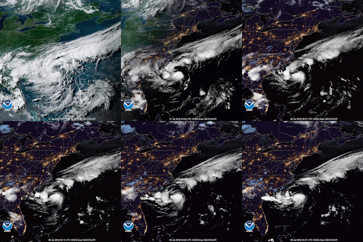
This little guy is still hanging out and doing a spot of fishing off the Carolinas at 32.9N, 75.1W. It must be a good spot because he's heading absolutely no-where. :-)
Although he is officially a Tropical Depression, I think he is already a Tropical Storm because there is good circulation in the entire lower half of the troposphere (currently his circulation is better developed than Tropical Storm Beryl...shh... don't tell her that). He is definitely not a hurricane at the moment because there is no circulation in the upper troposphere. A plane is flying through the system tonight, so I fully expect to see him named once they get that data. The satellite image also shows a storm with a good 'outflow' (that serrated edge you can see on the east side):
The forecast has him hanging out for the next couple of days, and then heading northeast:
I'll go with the NHC on this one, as for me, it is tricky to see where he'll go because he is stationary and the pressure around him will change.
He is also over an area of warm surface waters with the upper 75-100m warmer than 26.5 deg C so he could intensify. The forecast is that he will be a Hurricane by Tuesday. I'm not sure if this will materialize yet because at the moment I do see some wind shear to the east. However, until he moves, it's a little murky.
That's it for now, but of course, more soon!
Toodles,
J.
--------------------------------------
DISCLAIMER:
These remarks are just what I think/see regarding tropical storms (my storm blog). If you are making an evacuation decision, please heed your local emergency management and the National Hurricane Center's official forecast. This is not an official forecast.
--------------------------------------
Sunday, July 08, 2018
Subscribe to:
Post Comments (Atom)


No comments:
Post a Comment