Well that was a pretty good day. I just finished watching the semi-final of Euro 2020 because I'm in England and that's what we do. It was England vs. Denmark and a very exciting match - England won 2-1 which means they will be playing against Italy in the final on Sunday!! It's been 55 years since they were in the final of this tournament - the last time they got this far was the 26th July, 1966 when they beat Portugal 2-1! History, baby! Woohoo.... and the TV commentator just told me to call my boss to tell them I won't be going in tomorrow morning because we have to celebrate all night... well ok, if I must.
I have to say, it's been years since I watched an entire football match (with overtime and additional minutes to boot!) and I'm jolly pleased to have watched this one. There are a lot of guys with very good looking legs that apparently don't work very well because they keep falling over. ;-)
You may be wondering if you have wandered into the wrong blog, expecting storms and getting a football update. No, you are in the right place... I have spotted the latest and greatest in wind sensor technology...
Coincidentally, that seems to be about how strong the wind was in parts of Tampa Bay today as Elsa went by. She did regain weak cat 1 hurricane strength (75mph) as she passed Tampa Bay, but that was only for about 6 hours or so before weakening again.
Tropical Storm Elsa made landfall at around 11am local time in Taylor County, about 65mp NNW of Cedar Key, along the Florida panhandle close to the Big Bend as a strong Tropical Storm with winds of 65mph:
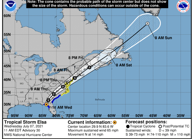
She has of course weakened even more since then and is currently at 30.3N, 83.5W, over northern Florida and heading N to Georgia at 14mph. Winds are now 50mph, central pressure is 1002mb which means she is a weak Tropical Storm (range: 39-73mph). Her convection has decreased quite a bit since she made landfall, but that wind shear still exists and the bulk of it is to the east:
I know the official forecast calls for her to intensify again in a couple of days as she re-emerges over water, but I think she may fall apart as she crosses land. In addition to being over land (always a dodgy place for a tropical storm), there is also a teensy bit of wind shear between her current location and her emergence over water in northeastern US, and the water up there is a cool - surface temperatures are around 22-23 deg C (far too cold for any self-respecting storm).
It looks like maximum storm surge was around 2.5 ft above normal (at Cedar Key for example), with most places reaching 1.5-2ft above normal.
I got photos from our intrepid on-the-ground reporters in St. Petersburg, Chris K. & Peter R. (photo credit), whose Papaya Tree decided to have a rest from the soggy ground and heavy fruit.
Papaya and mangoes... I'm going over there for a visit!
So, overall, she's mostly a rain event now as she crosses land. This is my last update on Elsa unless she does something crazy. Luckily she'll be long gone by Sunday... between the Wimbledon finals this weekend and the Euro 2020 Football Cup final, I don't know if I'll have time for storms! ;-)
The next storm will be from the Flintstones... Fred.
Toodle pip!
--------------------------------------
DISCLAIMER:
These remarks are just what I think/see regarding tropical storms - not the opinion of any organization I represent. If you are making an evacuation decision, please heed your local emergency management and the National Hurricane Center's official forecast and local weather service announcements. This is not an official forecast. If I "run away, run away" (Monty Python), I'll let you know.


No comments:
Post a Comment