Wednesday, August 30, 2017

Tropical Depression Horrible Harvey, Tropical Storm Irma, and Tropical Storm Lidia: August 30, Update A

I am writing to you from another planet today, so this will have to be a short note - but after the very long ones over the last few days, I’m sure you are all relieved! ;-)

Tropical Depression Horrible Harvey
Thank goodness he has made landfall for the final time – and I mean final. There is no doubt in my mind that they will retire the name after this season and replace it with another ‘H’ name. ‘Humperdink’ perhaps (or Hodor - thanks Chris H. for the GoT names suggestions!)? Any storm that causes excessive loss of life and damage gets retired.

I know you have read (or watched) the stories and stats, but (from the BBC who got it from the NWS I think), an interesting graphic to depict what the record 52 inches of rainfall(!!) looks like:

That’s just rainfall, not flooding from a river! The flooding was extensive, covering an area about 15 times the size of Manhattan and unfortunately, it looks like at least 25 people lost their lives.

He is currently at 31.2N, 92.6 W, heading NNE at 8mph. Central pressure is 998mb, winds are 35mph.  He still has some circulation but not a lot of convection (thank goodness), which we can see in the satellite imagery:

He will be moving across a number of states:
but shouldn't be too much of an issue (I hope). I may be back for one more update on Harvey. 

Tropical Storm Irma
This is the next one to watch – she was the Atlantic Blobette out in the eastern Atlantic yesterday. Although her convection is not quite cohesive, you can certainly see the structure in the infrared satellite imagery and almost don’t need to look at the vorticity (circulation) maps to see what a beauty she is going to be!
 She is 16.4N, 31.2W, heading W at 15mph. Her central pressure is estimated to be 1001mb, and winds are estimated to be 60mph. I think she may be a bit stronger because there is already a signal in the upper troposphere (see graphs below), which suggest to me that she is closer to hurricane strength – so maybe 70-75mph. I agree with the NHC that she will be a hurricane very soon.

The forecasted track will take her generally westward towards the Caribbean:
I think that shift to the south is reasonable, but it is too soon to say how far south she will go as she approaches the Caribbean – I think there’s a possibility that she will remain in the southern half actually.

Tropical Storm Lidia (E. Pacific)
This is the Pacific Blobette from yesterday and also got named today, although she is not as well developed as Irma by a long shot. She is at 20.7N, 109.2W, heading NNW at 7mph. Min pressure is 1001mb, winds are 40mph – so she is barely a Tropical Storm at the moment. You can see the difference in the structures of Lidia, Harvey, and Irma in the vorticity maps… the lowest level of the troposphere (850mb):
 The middle of the troposphere (500mb):
 And the upper troposphere (200mb):
From these you can see a couple of things - first, in the upper level map, you can clearly see Irma's circulation. Second, you can see that Lidia is not very well developed (with that elongated blob in the middle level of the troposphere) as even Harvey at this point, but she does have some jolly decent convection, which means rain and possibly thundery weather:
The forecast is for her to head towards the Baja area on Friday:
So take your rain ponchos and wellie boots!

Now I must go and observe the wildlife on this planet.
Until tomorrow!
J.


-->
Blogs archived at http://jyotikastorms.blogspot.com/
Twitter @JyovianStorm
-------------------------------
DISCLAIMER: These remarks are just what I think/see regarding tropical storms - not the opinion of any organization I represent. If you are making an evacuation decision, please heed your local emergency management and the National Hurricane Center's official forecast and the National Weather Service announcements. This is not an official forecast. If I "run away, run away" (Monty Python), I'll let you know. 

Tropical Storm Horrible Harvey, Two Atlantic Blobs, and a Pacific Blobette: August 29, Update A

Phew… what a mess! Have I said that already? Over the past few days I have heard from some of the intrepid on-the-ground reporters in Houston who still have power (thank you for the updates!) and it has been on-going; keeping the water out, catching a short nap, checking on the water levels, catching a short nap, readjusting and doing something to keep the water out, catching a short nap…. But that is changing. Finally!!

Tropical Storm Horrible Harvey
He is currently at 29N, 93.6W, heading NE at 6mph. Officially his central pressure is 994mb, and winds are now 50mph, which means he is a little stronger and is a mid-strength Tropical Storm (TS range: 39-73mph):
I think he might be a little stronger because the circulation is very strong in the lower half of the troposphere, and the upper troposphere is not quite clear yet – although it is not so much from the storm as it is from a general low pressure area, which is why he is not a hurricane. But I wouldn’t say more than 60mph.

His track shifted to the east and the NHC have adjusted accordingly, with FINAL landfall now in Louisiana tomorrow morning (phew!):
The big shift today was that his center went past Galveston and to the east… and as it did, the winds shifted and the rain started to die down. This means that the waters can finally start flowing back out into the Gulf!  

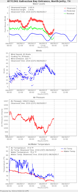
From Tides Online, you can see the storm surge going down. For example, at Galveston Bay it has dropped by 2 feet in the last 12 hours, although it is still over 0.5 feet above normal:
Although the initial storm surge is dying down, I think we may be starting to see a rise again at this location as the flood waters upstream come charging down. I really hope the drainage is quick! Looking in Louisiana, which is on the east side of the storm, the winds are still pushing water onshore (I know there is some concern amongst you about New Orleans, where some of the pumps failed a few weeks ago). Although some places in Louisiana that are closer to Harvey have had over 17 inches, so far New Orleans has had around 5 inches of rain (the NWS forecast is 5-15 inches), and at New Canal station, the water level is currently rising and storm surge is almost 2 feet above normal:

The rain in Texas has been the largest rainfall event on record in the US and there is a lot of concern about the Houston dams, and rightly so. I found this lovely quick explanation of where the dams are for those of us not in Houston, and what they are supposed to do, and what they will do over the next few days.

With over 13,000 people being rescued, I have had a couple of conversations about why people weren’t under a mandatory evacuation order. That’s a slightly more complicated discussion and I’ll save that for a day when there isn’t as much going on…

Atlantic Blobette (formerly known as the Florida Blobette)
We are all set with this one. It has moved away from the US coast and warm waters of the Gulf Stream and has transitioned so it is no longer a tropical storm; the circulation in the middle of the troposphere is not as well formed as yesterday. I still think it was Tropical Storm Irma - by definition, a storm with a closed circulation and winds of over 39mph is a Tropical Storm, but no matter now as we are done with this! Florida and some parts of the eastern seaboard got some rain, but hopefully of the more good-make-the-flowers-grow kind!

Atlantic Blobette TWO!
There is another blobette lurking way out there at around 16N, 27W (west of the Cape Verde Islands) heading in a general WNW direction at about 15-20 mph. The NHC have given this a 90% chance of becoming a Tropical Depression in the next day or two. It really doesn’t have good convection yet, and the circulation is still not quite there in the lower half of the troposphere, but I could see this slowly improving into a Tropical Depression relatively soon. The Saharan Air Layer is not very strong at the moment, so there isn’t that dry dusty air to inhibit development. Click here for a refresher on the Saharan Air Layer. I’ll be keeping an eye on this blobette.

Pacific Blobette!
A special request for a quick update on the Pacific Blobette today! Woohoo… I’ve gone global (is that a good thing?)!

This is officially at 18.1N, 108.2W, heading NW at 10mph. Central pressure is estimated to be 1005mb, with estimated winds officially at 30mph. This has to get a little better formed until it even becomes a Tropical Storm. In fact, it is so poorly organized that it is difficult to see the center of circulation at the location the NHC currently have it at… from this satellite image, it looks like it could be at 17.5N, 109W… and if the center is off, then the models for track will also be a little askew.

The circulation (vorticity) is not very well developed in the lower half of the troposphere yet. You can clearly see the difference in circulation between this and Tropical Storm Harvey (which is off to the right edge of the maps below, and officially has 50mph winds – even though I think that’s an underestimate) in the lowest level (850mb) and middle level of the troposphere (500mb):


Clearly, Harvey is more intense (darker red/white) and more of a red blob (you could say it was like a pox!) in the entire lower half of the troposphere compared to this one which is a little more elongated. The forecast calls for this to be a Tropical Depression in the morning and a Tropical Storm by tomorrow evening, heading towards the Baja peninsula by Thursday (sorry!):
I don’t see anything that would really change the direction of this track much (but the data I have access to is quite sparse), but as it is so poorly organized at the moment, it seems unlikely that it would be a very strong storm. We will have to see if the center really is where they think it is – if it is to the west of the current location (which is what it looks like in the satellite image tonight), then the track may also shift to the west. Hopefully we’ll know more tomorrow, but if you happen to be going to the Baja area on Thursday, pack to drink the umbrella drinks under an umbrella for the couple of days of your visit, with sunshine to follow. This one does have some rain in it (and it is to the east side of the center) because the water is very warm in this region (over 28 deg C at the surface, with the upper 50-75m warmer than 26 deg C).

This one will be Lidia if it is named.

Until tomorrow, toodles!
J.


-->
Blogs archived at http://jyotikastorms.blogspot.com/
Twitter @JyovianStorm
-------------------------------
DISCLAIMER: These remarks are just what I think/see regarding tropical storms - not the opinion of any organization I represent. If you are making an evacuation decision, please heed your local emergency management and the National Hurricane Center's official forecast and the National Weather Service announcements. This is not an official forecast. If I "run away, run away" (Monty Python), I'll let you know.