
I was on intergalactic travel today (Earth to Planet Dragoncon)... and so of course Dorian would decide that today is a perfect day to make a run for it and becomes a Hurricane. Tsk tsk. I've had a few messages from my lovely readers so I'll jump right in...
Hurricane Dorian
The story so far: he crossed into the Caribbean yesterday and interacted enough with St. Lucia that he wasn't a full card-carrying member of the Hurricane variety as he approached the northern Caribbean. His track did, indeed, shift to the north and east, and earlier today he passed the US Virgin Islands instead of directly crossing Puerto Rico, becoming a weak cat 1 storm (cat 1: 74 - 95 mph) as he passed by St. Thomas (hope it wasn't too bad out there my friends!).
He is currently at 18.8N, 65.5W heading NW at 14 mph. Winds are now 80mph which makes him a weak-to-mid strength storm (cat 1: 74-95mph), central pressure 997mb.
There is circulation in all levels of the troposphere now, although it isn't very strong in the upper levels, so I agree with this intensity. Backing this is that he doesn't yet have a good eye, which is further evidence that his winds are below around 90mph. I also agree with the forecast that he will get stronger in the next couple of days for a number of reasons. First, the waters are warmer than 28 deg C, with the upper 100m being warmer than 26 deg C, which means he has enough food to get stronger. Second, there isn't much wind shear in front of him - not until he gets closer to the Bahamas. Third, there isn't any land in front of him as he heads NW. And fourth (as if we needed any more reasons!), there isn't any dry air in front of him:

Sooo.... I have to agree with the NHC guidance that he will get stronger and may become a major hurricane (cat 3 or higher) in the next few days.
As for the track, the current forecast has him heading NW and then turning to the west and towards Florida (in case you hadn't noticed if you live in that part of the world!):
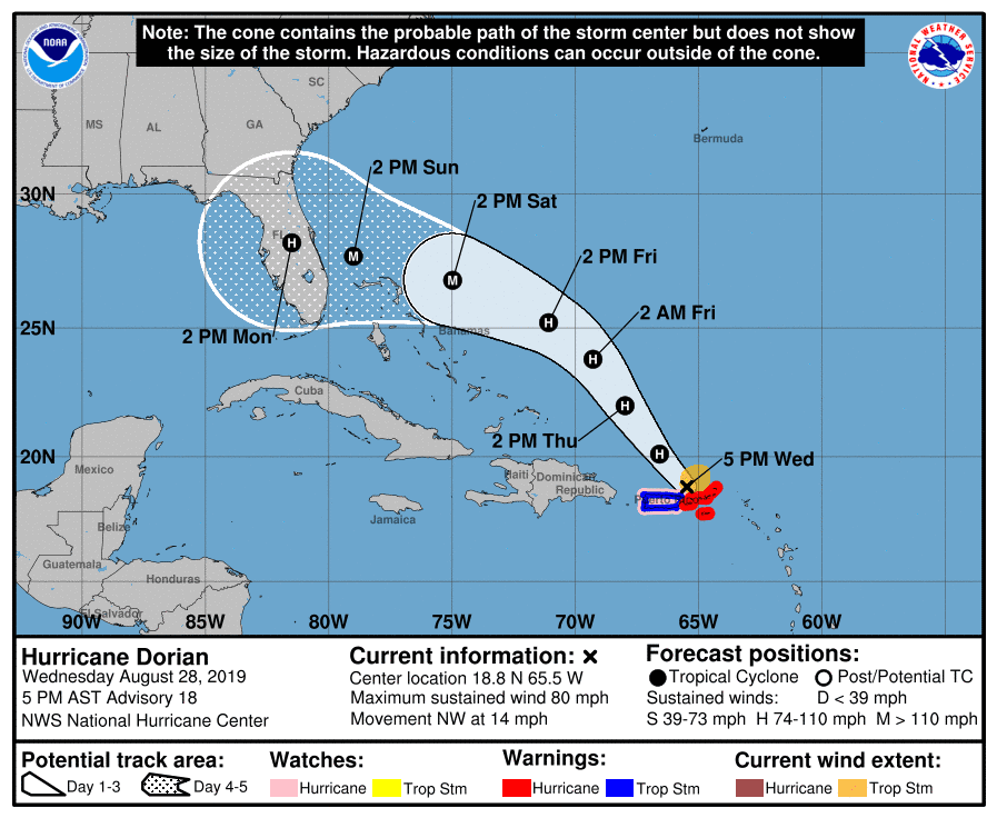
I would definitely get ready (as I am sure you are)! It's still 4 days out from any landfall, so a lot can change as far as the track of course. And if he crosses the Bahamas then his intensity may decrease a little. There is a possibility that his track may shift slightly more to the west/south as he gets a little further from the Caribbean, taking him closer to the southern Bahamas on Friday.
Must run... TS Erin (very weak) will have to wait.
More soon (maybe even later today)!
Ciao for now,
J.
Twitter: jyovianstorm
--------------------------------------
DISCLAIMER:These remarks are just what I think/see regarding tropical storms. If you are making an evacuation decision, please heed your local emergency management and the National Hurricane Center's official forecast. This is not an official forecast.
--------------------------------------


No comments:
Post a Comment