
"Bit of a busy day. Distressingly little time for sloth or idleness!" (An Ideal Husband)
Hmm, so things are looking good at the moment, but if you are in the northern Gulf, it's a tad complicated, but I'd get ready for some wet and windy weather!
In chronological order... Cristobal is now a Tropical Depression with winds of 35mph, central pressure 1000mb. He is at 17.8N, 90.4W, heading E at as fast as a running turtle, at 3mph. He is expected to turn north tonight. It looks like he made slightly more of an inroad into Mexico than expected, which is good because he will be weaker when he re-enters the Gulf tomorrow evening:

The other jolly news is that his circulation has deteriorated. It is still there, but it looks more elongated and like a low pressure trough than a tropical storm, which is a step in the right direction and I agree on the TD status.
The worst of the rains have been over Belize, parts of Guatemala, and the Yucatan peninsula, with a band of rain drops and kittens being blown across to Florida

Now... tomorrow evening (Friday night), he will emerge back into the Gulf. What we are watching for is how much of a hit does he take before getting back into the Gulf. If he makes it out of Mexico somewhat intact (winds of 35 mph), then the track the NHC have forecast seems about right and he will head towards the central northern Gulf - I don't have the detailed pressure data to think otherwise.
The next question is how strong is he going to get? As I mentioned yesterday, once he gets into the Gulf, we will see the competing forces of The Atmosphere (strong wind shear will inhibit him) vs. The Ocean (warm seas will feed him). You can already see the wind shear in action in the satellite imagery - that's why the clouds are streaming gaily off to the northeast and over Florida. One more factor that will keep him in check in 'The Atmosphere' is a region of dry air to his west (the yellow area), which you can see in this satellite image of water vapor:
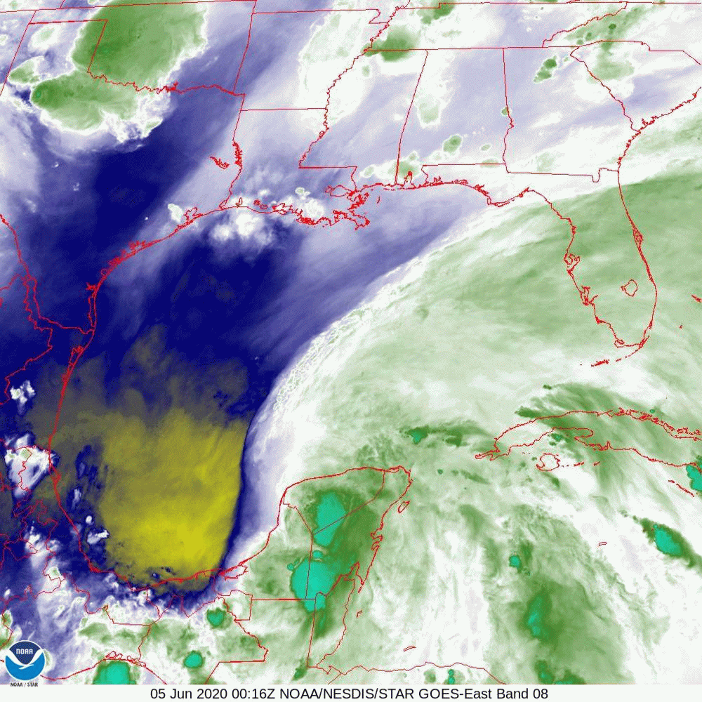
I've seen dry air knock the wind out of fully grown up hurricanes (all puns always intended ;-)), so this dry air is a good thing.
However, in the 'The Ocean' camp, sea surface temperatures across the entire Gulf are currently warmer than 26.5 deg C (warm enough for a storm buffet), with waters warmer than 27 deg C in the southern and middle parts of the Gulf of Mexico. But, adding to that, it looks like the Loop Current (see this post for the Science Alert! on the Loop Current) (or a Loop Current eddy) is in the middle of the Gulf, pretty much in his path. This image showing the depth of waters that are warmer than 26 deg C (from NOAA/AOML):

That patch of yellow - that's where waters are warmer than 26 deg C over the upper ~100m of the water column. He will be over that sometime around Saturday night if he is on the forecast track. So, if he is still intact from the wind and dry air by the time he gets there, I expect to see some strengthening as he crosses that part of the Gulf. Currently, the NHC forecast is that he will have winds of around 50-60mph on Saturday night... I think he may be stronger if he crosses that patch (and if he emerges from Mexico with winds already at 35mph).
As I said, the first thing is to see how much he weakens tomorrow as he crosses Mexico. But may I just say, what a mess! Mexico has a very high rate of Covid-19 cases already, so even if he is just a weak storm, it's not been a groovy situation.
Eyes on you tomorrow, TD Cristobal!
Toodle pip,
J.
J.
Twitter: jyovianstorm
--------------------------------------
DISCLAIMER:
These remarks are just what I think/see regarding tropical storms - not the opinion of any organization I represent. If you are making an evacuation decision, please heed your local emergency management and the National Hurricane Center's official forecast and local weather service announcements. This is not an official forecast. If I "run away, run away" (Monty Python), I'll let you know.
--------------------------------------


No comments:
Post a Comment