"Little high, little low, Any way the wind blows doesn't really matter to Me, to me..." - Name that 'Fred' (hint: another classic, just like yesterday's guest musical number). ;-) And while you are thinking about that...
Tropical Depression Fred
A lesson in keeping an eye on the entire Cone of Uncertainty - he continued to remain on the southern/western edge and is now officially firmly over Cuba. The NHC still have his wind speed as 35 mph, central pressure 1013mb, which is quite remarkable as that is exactly what it was over 24 hours ago when he was over water. As I said, if he goes over land and with that wind shear he will weaken so I'm surprised that they kept his intensity at that level, but more on that in a moment.
Officially, his center is at 22.7N, 80.6 W and he is moving W at 12mph:
From the maps, it looks like he made landfall in Cuba sometime around 11am this morning (local time).
I think he's in a different location than the NHC think, and I think he's a different strength than they think as well. Here is his satellite imagery:
It does rather look like he is actually south of Cuba from the convection - although there is still some wind shear which means the lowest levels of vorticity (circulation) are a little west of the middle level of vorticity (circulation). Looking at the vorticity maps, the low level center looks like it is south of the center that we see on the NHC map above. Here is the lowest levels (850mb):
And here is the 500mb mid-tropospheric level:
So, I think he was weaker than a TD as he crossed Cuba, but he is now interacting with the water on the southern side of Cuba so he has a lot of convection (rainfall) from that warm Caribbean water.
The NHC have some doubts on their forecast:
"Interaction with land and southwesterly shear has continued to take a toll on Fred this evening. It is very difficult to determine in infrared satellite imagery and recent surface observations from Cuba if a closed circulation still exists, however the system is maintained as a tropical depression for now."
They will send a plane in tomorrow morning so we should have a much better idea of if he has dissipated or if he is south of Cuba. At the moment, it's all a bit up in the air (all puns are perfectly acceptable! ;-)). The longer term track has shifted westward as he remained to the south/west of the cone, and it may continue to shift westward if he doesn't dissipate before then.
I'm looking forward to finding out the data from the plane tomorrow.
Tropical Depression Seven
This was our Atlantic Blobette from yesterday, who today has the same level of winds as Fred - 35mph and actually has a lower estimated central pressure at 1010mb, which suggests she is stronger than Fred. She is currently at 15.5N, 53.8W, heading W at a rapid 21mph.
The current forecast trajectory takes her over the VIs and Puerto Rico:
The forecast also says she will be Tropical Storm Grace by tomorrow. I think she is already a weak Tropical Storm actually - you can see her convection from the satellite image above. And she has good circulation throughout the lower half of the troposphere which we can see from the vorticity maps. Unlike Fred, she isn't under as much wind shear because the red blobs are more-or-less aligned with each other in both maps.
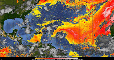
She is just moving into an area where sea surface water temperatures are warmer - 28 deg C - and the upper 100m of the water column is warmer than 26 deg C. But, although that would feed her, she won't get beyond a weak TS tomorrow because she has some dry and dusty air around her - part of the dusty Saharan Air Layer... ooh, time for a drum roll because it's time to "Open your eyes, Look up to the skies and see" (from the same song that opened this act :-))...
--------------------------------------
DISCLAIMER:
These remarks are just what I think/see regarding tropical storms - not the opinion of any organization I represent. If you are making an evacuation decision, please heed your local emergency management and the National Hurricane Center's official forecast and local weather service announcements. This is not an official forecast. If I "run away, run away" (Monty Python), I'll let you know.


No comments:
Post a Comment