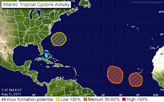
Of course, these are areas of interest that the NHC are also watching - sometimes known as areas where clouds loiter in a suspicious manner, which makes a change from watching youngsters in Britain doing the same thing (and what the heck is going on over there?!? I’ve not even been gone a year yet! Deary me, it wasn’t like that back in my day…).


So, apart from the news, the two areas of interest I’ve been watching most closely this week are the ones that came off Africa. Of all the yellow and orange crayon markings on the map (included here), those seemed like they had the most potential to me. One currently has a convective area around 17N, 40W (Blob) and the other has a convective area around 12N, 31W (Blobette) (see satellite IR map). Some of the computer models show both of these clipping the northeastern Caribbean, but I am not yet convinced of this, especially not with the Blob.
The Blob left Africa on August 7th I think. Back when the UK was a normal country, before the orcs invaded. The Blob had pretty good low-level circulation and convection back then, but I was waiting for it to develop into something a bit better looking. However, it continues to struggle. The circulation is not very well confined (it’s a bit blobby!) and the convection is also looking a little peaky at the moment. It looks like it is heading generally NW towards a low pressure front (out in the middle of the Atlantic), and it might interact with that tomorrow. You can see this front on the satellite IR image – the main rainy area is around 23N, 55W, but the clouds stretch from the Caribbean up towards the NE Atlantic. Although the NHC keep increasing the % chance of this developing into a tropical system, I will refrain from writing more on this until it looks closer to hatching (which will probably be tomorrow now that I’ve written this! ;-)).
The Blobette left Africa a day or two after the Blob. Again, although the % chance of this developing is currently at 40%, I don’t really see any decent circulation in this system at the moment. Of the two, this one looks like it has the better chance of making it into a tropical storm and moving more westward across the Atlantic. Again, it is a bit too early to tell.
Maybe there will be more tomorrow. Maybe.
Toodles!
J.
Blogs archived at http://jyotikastorms.blogspot.com/
Twitter @JyovianStorm
-------------------------------
DISCLAIMER:These remarks are just what I think/see regarding tropical storms - not the opinion of any organization I represent. If you are making an evacuation decision, please heed your local emergency management and the National Hurricane Center's official forecast and the National Weather Service announcements. This is not an official forecast. If I "run away, run away" (Monty Python), I'll let you know.
-----------------------------------------


2 comments:
"...areas where clouds loiter in a suspicious manner."
Thanks! Now, for the rest of this hurricane season, I'll be unable to picture the Atlantic as anything but a giant mall food court near a Hot Topic.
Haha... I might have to include that the next time I see them loitering!
Post a Comment