A sunday afternoon
cheese and wine o’clock update, which may take a little time as there is so
much going on!
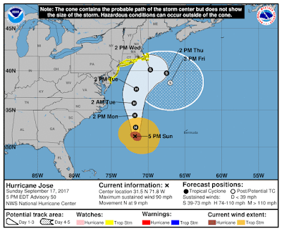
Hurricane Jose
Like
yesterday, you can see the clouds streaming off to the northeast because of
wind shear, which of course puts Bermuda in the path of some of those rain-bands. No golf today.
The wind shear looks
like it will continue to remain strong (inhibiting too much development) until
he gets to around the latitude of DC. But he is passing over warm water with
sea surface temperatures of over 29 deg C, and the upper ~75m warmer than 26
deg C, which will work against the wind shear. Overall, a cat 1 storm for the
next couple of days seems likely.
From Tides Online, it
looks like the water levels along the coast are generally between 0.5-1ft above
normal all the way up to Chesapeake Bay, where water levels are currently 1ft
above normal.
<Technical Alert!> A useful source of general marine and coastal data (until he passes North Carolina) is the SECOORA – the Southeast Coastal Ocean Observing Regional Association – website. You can go to their Marine Weather Portal and click on any of the blue dots, which will show you the measurements at that location. I clicked on the one closest to Jose – a NOAA NDBC (National Data Buoy Center) mooring, which shows that the wind speed was around 23.2 knots (almost 27mph)
Hurricane Maria
Her convection
has certainly picked up today, and given that her circulation is strong (which
we can see from the vorticity maps above), I would say she is stronger than
this – maybe with wind speeds of around 85mph (no higher than 90 mph as there
is no visible eye yet). However, I would agree that she is a cat 1 storm. She
continues to move over warm water of course, with the sea surface waters over
29 deg C, and she is now in an area where the upper ~100m of the water column
is warmer than 26 deg C which means she will continue to grow. There is very
little wind shear ahead of her, and although there was some dry air that was
entering the system earlier, that is now also diminishing, which we can see
from the improvement in convection. This all points to a mid-sized cat 1 storm
at the moment, steadily increasing to a stronger cat 1 overnight, and possibly
a weak cat 2 tomorrow (depending on her interactions with the islands) – which we
will see if she has an eye.
I think she will
continue WNW, but may stay a little more on the southern side of that cone,
passing through to the Caribbean tomorrow evening/early Tuesday close to Martinique (maybe between Martinique and St. Lucia). If her center passes over any of these
islands, they will take her down a notch.
Tropical Depression Lee
Lee was downgraded to a Tropical Depression today with winds officially
at 35mph, central pressure at 1007mb (TD range: 17-38mph). The good news is
that he got caught in the last vestiges of the Saharan Air Layer:
However, it is returning because he is still over warm water and I would place him still as a weak Tropical Storm. This is a battle between the dry and dusty atmosphere, and the warm and wet ocean! He is currently at 13.2N, 37.3W, and continues to head W at 8mph. I think he will continue a little more on the southern edge of the cone in the NHC track:
But he is not a
very well developed storm now at all. His structure is quite poor - the lower troposphere circulation is now disjointed from the mid-troposphere circulation (which you can see in the vorticity maps above), so it is a little tricky to pinpoint a good center. He has recently entered an area of wind shear to the north,
which you can see as more clouds are streaming off to the northeast. If he
continues more westward, he will remain generally south of the shear and
continue to remain a little stronger. If he moves on the NHC track, then I
agree with them that he will get hit by that wind shear and not get too far. Given the NHC tracks have been pretty good, I will go with their version.
More tomorrow!
Ciao,
J.
Blogs
archived at http://jyotikastorms.blogspot.com/
Twitter @JyovianStorm
-------------------------------
DISCLAIMER: These remarks are just what I think/see regarding tropical storms - not the opinion of any organization I represent. If you are making an evacuation decision, please heed your local emergency management and the National Hurricane Center's official forecast and the National Weather Service announcements. This is not an official forecast. If I "run away, run away" (Monty Python), I'll let you know.


No comments:
Post a Comment