Time for a look at the game afoot with my afternoon cup of tea here.
Hurricane Ian. Are you ready? Got your ice cream stocked up?
Track: he is at 20.3N, 83.2W, heading NNW at 13mph. The track forecast did move to the east and is taking him to the west coast of Florida, close to the Tampa Bay area (and where this blog started in the first place, so I have a lot of peeps in that area, some of whom are evacuating I have heard):
I can see why the track looks like it does - there is a high pressure building to the right of the track before it gets to Florida (remember, storms go clockwise around a high pressure system), which is why they think he will move a little more in the NNW direction before curving around it to the NNE. But, very crucially, where he makes landfall relative to Tampa Bay - north or south of the Bay - will make a huge difference.
Why? That's because the storm is a low pressure system, so the winds are pushing water around it in a counterclockwise (anticlockwise) direction. If he lands to the south (corrected from earlier when I had north written here - thanks to Steve M. for catching this!), the water will mostly get pushed out of the Bay - or along the Pinellas County side for a short while. If he lands to the north of the Bay, the water is going to get pushed into Tampa Bay (and on shore along all bays and coastline to the south) - and along with the water from the rain, it will take a long time for the Bay to drain so the water can take a while to decrease. The same thing applies in Sarasota and other areas along the southwest coast of Florida.
For storms, remember - run from the water, hide from the winds. The greatest loss of life in a tropical cyclone is from water (storm surge, flooding etc), not from the winds. SO... if you are in an area that floods under normal rainfall, or if you are near a river bank, please evacuate sooner rather than later - I am sure your local emergency managers are saying the same thing. Otherwise, if this was a cat 4 or 5 storm, I would also evacuate if I could.
I think he may move a little more the east than expected - meaning a landfall in the southern part of the cone of uncertainty (between - Tampa Bay and Naples) we will know more tomorrow of course.
Itensity: He is now officially a mid-size cat 2 storm with winds of 100mph (Cat 2 range: 96-110mph), central pressure 972mb. I think he may be factionally weaker than this (maybe 95mph based on his satellite appearance) and I know they say rapid intensification, but I think he was a cat 1 yesterday so in my head it's not been so rapid. He is turning into a good looking storm:
And the convection has really picked up today so Cuba and part of South Florida and the Bahamas are already getting bunches of rain and thundery weather...But you will see that large parts of the storm are still in that green range - including around the center of circulation - which is why I think he may just about be a cat 2 storm. Also, interestingly, the strongest convection is to the south and diminishes in his northern flank - it hasn't yet fully wrapped around his center. This is partly because he is starting to interact with Cuba (which will help to keep his intensity down a bit) and partly because although the sea surface temperatures are warm, the warm water is really deepest on his southern side.
For those of you who want to see the spinach he's been eating to make him stronger, this is for you...<Science and Forecasting Alert!> The Loop Current (System). The Loop Current is part of an ocean current system that flows from the Caribbean into the Gulf of Mexico through the Yucatan Strait, and then out of the Gulf of Mexico through the Straits of Florida, and up the east coast of the US. How far it extends into the Gulf of Mexico varies from year to year and month to month. As this current flows around Florida, it changes name to become the Florida Current. Then as it flows up the east coast, it changes name again and is known as the Gulf Stream. It leaves the US east coast around North Carolina and flows across the north Atlantic to the UK. Why is this current system important for tropical storms? This current system is well known because it has the deepest warm waters, and is very fast flowing - but the current also has offspring that can also have deep warm waters (all these offspring are called Eddy by the way). The deep warm waters mean that tropical storms that pass over any part of this current system or over any warm water Eddies have a jolly good (British understatement) chance of becoming stronger.
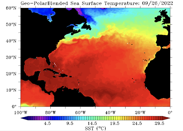
So, how can you see where these areas are? One of the places I look is buried within the vast network of websites that NOAA - the Office of Satellite and Product Operations has a site called Satellite Heat Content Suite (such a catchy name - made for a song lyric I'm sure! ;-)). I use the North Atlantic page: https://www.ospo.noaa.gov/Products/ocean/ohc_natl.html. If you click on this, you will see all sorts of maps. The two most useful for our purposes is the one on the top left - Sea Surface Temperature - which looks like this today:
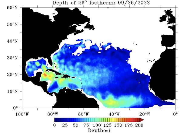
You can see that the waters where Ian is are over 29 deg C. The other most useful map (more so than the sea surface temperatures) is the depth of the 26 deg C Isotherm - third one down in the right column and that looks like this today:
From this, we can see that Ian has been passing over that area of orange just south of Cuba - this is where the upper 150-160m of water is warmer than 26 deg C! No wonder he picked up some convection. <End Science and Forecasting Alert>
Going forward, there is a possibility that he is not a major hurricane when he makes landfall in Cuba - by the time he is a cat 3 we should see the eye more clearly - actually, if he's a cat 2 with 100mph winds, we should see the eye appear once in a while and I don't see that in the visible imagery. If he doesn't make landfall in Cuba as a major storm, then crossing Cuba will knock him down a bit. However, as he emerges, he will be over warm deep water again (as you can see in the map above - depending on the path he takes, it may not be for long so he may not get quite as strong again. All the models are showing that he will get stronger on the other side of Cuba of course, but we will see. The thing I'll be looking for is that eye and how strong he is when he gets to Cuba.
Stay safe out there - get ready - listen to your local emergency managers - eat ice cream - drink wine - Don't Panic! - be good!
Ciao for now,
J.
Blogs archived at http://jyotikastorms.blogspot.com/
DISCLAIMER:
These remarks are just what I think/see regarding tropical storms - not the opinion of any organization I represent. If you are making an evacuation decision, please heed your local emergency management and the National Hurricane Center's official forecast and local weather service announcements. This is not an official forecast. If I "run away, run away" (Monty Python), I'll let you know.


No comments:
Post a Comment