Oh dearie me. Ian is such a nice human being... but not such a nice storm. In Cuba, he wiped out power - not just on the western side but across the entire island (for the first time).
Hurricane Ian
In Florida, he made landfall a few hours ago at Cayo Costa in the Sanibel/Captiva/Fort Meyers/Charlotte Harbor area of Florida and they are now experiencing what remains of his rougher weather as he passes by:
Winds are officially now 115mph, central pressure 960mb, which makes him a cat 3 storm (cat 3 range: 111-130mph). He is clearly not as robust looking as he was at landfall, which suggests a weaker storm - he still has an eye but he may even be a strong cat 2 at this point, but not too far off from his current cat 3 status.
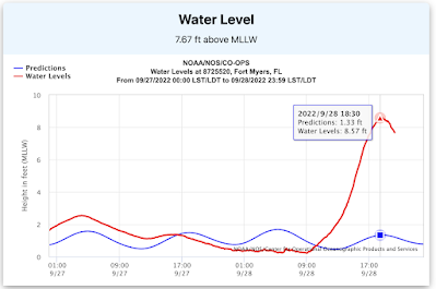
As expected, the storm surge has been incredibly high south of landfall. At Fort Myers, just south of where the center of the storm passed, at the location of the sensors, the water peaked at over 7 ft above normal:
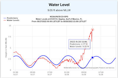
Further the south, in Naples, it looks like the sensor station stopped working when the storm was close enough, but even then it got to over 6ft above normal:
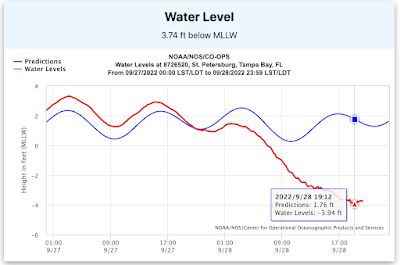
And in Tampa Bay to the north of the center - at St. Pete (my old home) the water levels were, as expected (isn't physics great?!), over 5 ft below normal:
In case you didn't click on the link yesterday on how to look this up for yourself, I'm doing that very clever thing of copying and pasting my own writing here for you...
<Technical Alert!> How to look up Storm Surge: Go to NOAA's website: tidesandcurrents (https://tidesandcurrents.noaa.gov/). If you click on this link, you will see an ugly cartoonish bad-suntan coloured map of the US (in shades of orange to represent the land - don't ask me why they picked this colour). Click on the state that you are interested in e.g. Florida. This will show you a much nicer colour map with a bunch of pins. These are the locations of the stations. You have to be careful though (if you are on a Mac especially) because the map is not static so you can accidentally scroll around and end up in the middle of the Atlantic, and will have to zoom out until the map you want re-appears and then zoom back in. A bit fiddly, I have to say.
By scrolling your mouse over the plot, the numbers appear showing the actual values (and then you have to do some complicated maths to get to the difference between the two - I know... get that calculator out! ;-)).
If you want to see the corresponding winds, air pressure and other handy-dandy data, you can scroll down. <End Technical Alert!>
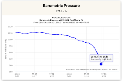
So here, for example, is the pressure field at Ft. Myers which clearly shows what the pressure was when the storm was closest to this location...
Interestingly, the eye of the storm passed very close to this area and the official low pressure of 937mb is quite a bit lower than the in-situ measurement here, which suggests that at this location at least the storm was not a cat 4.
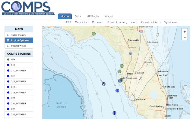
And if you want to have a look at data offshore, check out the University of South Florida College of Marine Science COMPS network (these are the moorings I got my PhD data from a <ahem> couple <ahem> of years ago ;-)), which is part of the Southeast Coastal Ocean Observing System and the Gulf of Mexico Coastal Ocean Observing System:
The air pressure at the mooring closest to the Hurricane Ian (C10) - just to the northwest of the track - showed a low pressure of 993mb with maximum winds of around 60mph, so that mooring was definitely under a Tropical Storm. To understand the storm and get a better idea of what it is like before making landfall, we need these good observations off shore!
He is currently at 27.2N, 81.7W, heading NNE at 8mph and is expected to leave Florida tomorrow as a Tropical Storm and head into southern South Carolina. Tricky to tell, but I think he is still going to head more to the eastern side of that cone of uncertainty, so again - get ready if you are in that cone.
I also heard about a downed power line sparking on the ground... as you go out after the storm, be careful of downed power lines in puddles please. Electricity + Water = Not Good.
Tomorrow we'll have a clearer idea of the impact on the west coast of Florida.
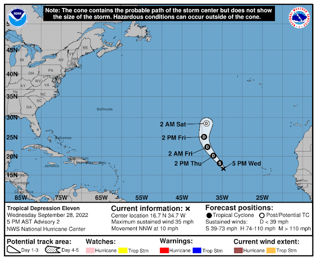
They expect her to become Tropical Storm Julia tomorrow. She doesn't have much circulation yet though - not even in the middle levels of the troposphere so we'll see if she is robust enough to be named. But she's another shortie (like me ;-)) and will stay out in the Atlantic, so this is going to be my only mention of her.
Listen to your emergency managers. Be safe! Eat Jaffa Cakes.
Blogs archived at http://jyotikastorms.blogspot.com/
DISCLAIMER:
These remarks are just what I think/see regarding tropical storms - not the opinion of any organization I represent. If you are making an evacuation decision, please heed your local emergency management and the National Hurricane Center's official forecast and local weather service announcements. This is not an official forecast. If I "run away, run away" (Monty Python), I'll let you know.





No comments:
Post a Comment