
I'm jumping right in with my customary Friday lychee martini in hand because there's a bunch of names on the menu today...

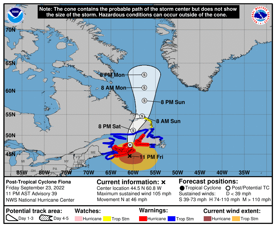
Post-Tropical Cyclone Fiona
She is at 44.5N, 60.8W, heading N at a roadrunner pace of 46 mph!! This forward speed is a clear indication that she is part of that front now and definitely not a tropical storm anymore, and the NHC have changed her designation to post-Tropical. Her wind speed is 105mph, central pressure is 933mb, which makes her a mid-size Cat 2 storm (cat 2 range: 96-110mph). She is going to head north and is expected to have Tropical Storm level winds by tomorrow:
There is a lot of wind shear and so her convection has not only decreased (because she is over colder water now) but it is also being pushed to her north and west:

So Nova Scotia, Newfoundland, and beyond are getting (or have had) some bouts of heavy rain but mostly this will be a windy storm. If it wasn't for that front she's got herself involved with, I don't think she would even have this much wind and would really be a weak cat 1 or Tropical Storm level system by now.
Tropical Storm Gaston
Just a quick note on Gaston, who is behaving exactly as predicted. He is at 38.9N, 29.5W, heading SW at 8mph. He's in the Azores and hasn't changed too much since we last saw him - 60mph winds, central pressure of 999mb. There is almost no convection in him so he's a paler version of Fiona - just a very breezy weekend in the Azores.

Tropical Storm Hermine
And gaining ground from behind, an Atlantic Blob that was identified as having potential when it was still over Africa has now overtaken our Caribbean Blobette of yesterday to become the new Tropical Storm Hermine (which now makes the Caribbean Blobette a Caribbean Blob called Ian :-)).
Hermine is at 19.4N, 20.8W heading N at 10mph. She's barely a Tropical Storm with winds officially at 40mph (TS range: 39-73mph), central pressure 1002mb. I think she's actually a bit stronger than this - she has good circulation in the lower half of the troposphere, and certainly has more convection (thundery weather) than Fiona and Gaston:

But we will never know how strong she really is because we don't have planes or anything else that can get into the system that far east (just off the coast of Africa) and give us data from within the storm, so the official assessment of intensity is really just a rough estimate. This is a problem in assessing intensity for storms around the world actually - satellites are great, but they only get us so far and then we need other ways of getting in situ data. In the meantime, Mauritania and the Western Sahara region is getting quite a few buckets of rain and will continue to do so for the next few days:

Tropical Storm Ian
This was our Blobette of yesterday. He is at 14.8N, 72W and is heading WNW at 12mph. He is also barely a Tropical Storm with winds of 40mph, central pressure 1005mb. The track has him heading to the general Florida region via a quite visit to the Cayman Islands and Cuba...

I am not going to comment on the track for now - the NHC are very good at within 24 hours, but I don't have enough data yet to see what is beyond that. All I'll say is that the cone of uncertainty is covering most of Florida, so everyone should be getting ready.
But intensity I can chat about. The Caribbean has a lot of warm water - the sea surface is warmer than 29 deg C and Ian is going over an area where the upper 125-150 m of water is warmer than 26 deg C, which means that the water he churns up is also warm enough to give him energy. This means that he has a lot of thundery and tornado-level convection, which we see from the infrared satellite imagery:

There is also a lot of moist air - not dry air- around him, so that will also allow him to get stronger. However, his circulation is not too strong overall yet, and more than that, there is some strong wind shear which means the convection is offset to the east from the circulation. But once those two align, which will happen once wind shear decreases (and that will happen soon), then we will be looking at a proper Tropical Storm.
I'll be back tomorrow - it'll be one of those weekends.
Ciao for now,
J,
Blogs archived at http://jyotikastorms.blogspot.com/
DISCLAIMER:
These remarks are just what I think/see regarding tropical storms - not the opinion of any organization I represent. If you are making an evacuation decision, please heed your local emergency management and the National Hurricane Center's official forecast and local weather service announcements. This is not an official forecast. If I "run away, run away" (Monty Python), I'll let you know.


No comments:
Post a Comment