
It's getting a bit hot out there, so I've got my ice cream and I'm ready to check in on Hurricane Ian...
Track: I, along with a few hundred thousand of my closest friends, have been watching Ian's track shifting to the east (and hence south) all day. He is currently at 24.4N, 83W, heading NNE at 10mph - making that turn towards the east sooner than officially forecast yesterday. This means he will be making landfall tomorrow, not Thursday:

That change in track also means his intensity will be a little different than forecast but more on that later. After landfall, the pressure fields are set up to push him across the state in the general NE direction we see in the official forecast - emerging maybe a little south of where the forecast is at the moment (perhaps the Daytona Beach/New Smyrna Beach area) - but still within that cone of uncertainty so please keep an eye on the entire cone!
Intensity: He is currently a mid-size cat 3 storm with winds of 120mph, central pressure 947mb (111-129mph). I agree with this estimate. Given that his track has shifted, his intensity will be different as well. There are a couple of things that are working to keep him a little in check. First, he won't be over that deep warm water as much as previously forecast and second, the wind shear has really picked up which you can see in the clouds that are streaming off to the northeast. The eye is already looking worse actually...
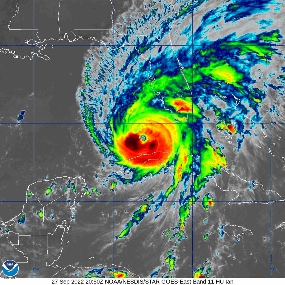

Yes, you guys in Newfoundland have clouds from Hurricane Ian as well!
The circulation is still strong throughout the troposphere, but the lower levels are being impacted by that wind shear. If Ian continues to deteriorate, he may be a weak cat 2/strong cat 1 on landfall. Regardless of what he is at landfall, because Florida is a flat and soggy state with Lake Okeechobee in the middle and the Everglades to the south, he will only go down one level by the time he crosses the state - so if he's a cat 2 at landfall, he will be close to a cat 1 on the other side.
And despite the wind and intensity, at landfall there will still be storm surge...


Be safe out there - listen to your local emergency managers!
Ciao,
J.
Blogs archived at http://jyotikastorms.blogspot.com/
DISCLAIMER:
These remarks are just what I think/see regarding tropical storms - not the opinion of any organization I represent. If you are making an evacuation decision, please heed your local emergency management and the National Hurricane Center's official forecast and local weather service announcements. This is not an official forecast. If I "run away, run away" (Monty Python), I'll let you know.


No comments:
Post a Comment