Wednesday, August 28, 2019

Hurricane Dorian: August 28, Update A

I was on intergalactic travel today (Earth to Planet Dragoncon)... and so of course Dorian would decide that today is a perfect day to make a run for it and becomes a Hurricane. Tsk tsk. I've had a few messages from my lovely readers so I'll jump right in... 

Hurricane Dorian
The story so far: he crossed into the Caribbean yesterday and interacted enough with St. Lucia that he wasn't a full card-carrying member of the Hurricane variety as he approached the northern Caribbean. His track did, indeed, shift to the north and east, and earlier today he passed the US Virgin Islands instead of directly crossing Puerto Rico, becoming a weak cat 1 storm (cat 1: 74 - 95 mph) as he passed by St. Thomas (hope it wasn't too bad out there my friends!).

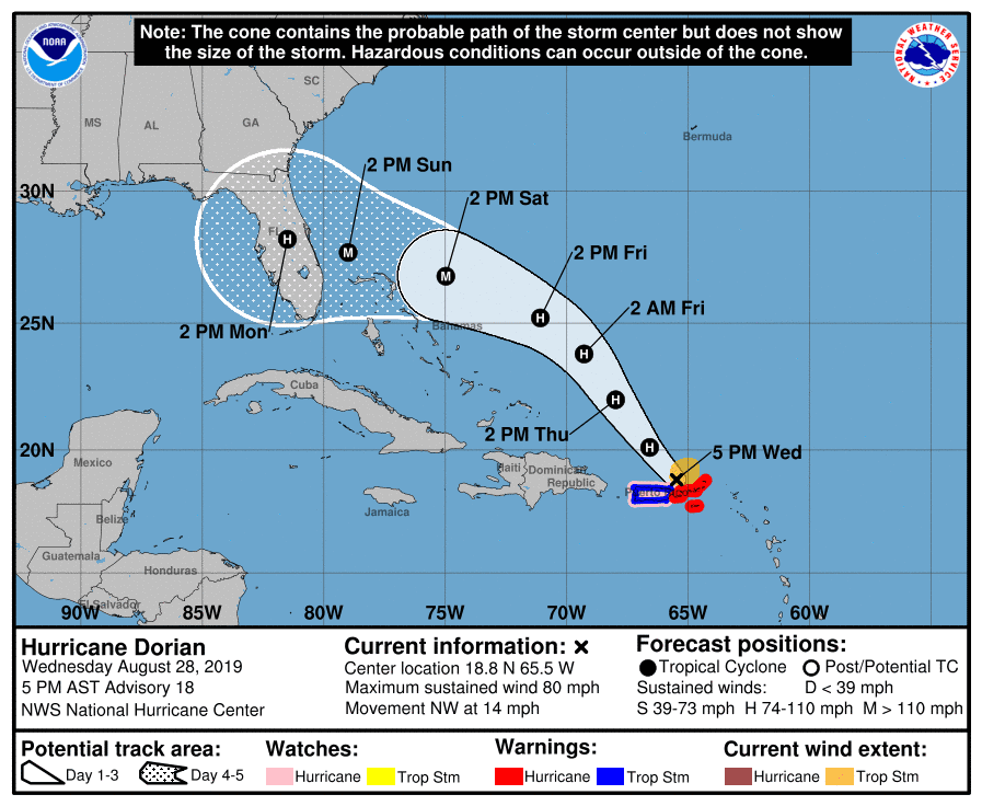
He is currently at 18.8N, 65.5W heading NW at 14 mph. Winds are now 80mph which makes him a weak-to-mid strength storm (cat 1: 74-95mph), central pressure 997mb. 

There is circulation in all levels of the troposphere now, although it isn't very strong in the upper levels, so I agree with this intensity. Backing this is that he doesn't yet have a good eye, which is further evidence that his winds are below around 90mph. I also agree with the forecast that he will get stronger in the next couple of days for a number of reasons. First, the waters are warmer than 28 deg C, with the upper 100m being warmer than 26 deg C, which means he has enough food to get stronger. Second, there isn't much wind shear in front of him - not until he gets closer to the Bahamas. Third, there isn't any land in front of him as he heads NW. And fourth (as if we needed any more reasons!), there isn't any dry air in front of him: 


Sooo.... I have to agree with the NHC guidance that he will get stronger and may become a major hurricane (cat 3 or higher) in the next few days.  

As for the track, the current forecast has him heading NW and then turning to the west and towards Florida (in case you hadn't noticed if you live in that part of the world!): 

I would definitely get ready (as I am sure you are)! It's still 4 days out from any landfall, so a lot can change as far as the track of course. And if he crosses the Bahamas then his intensity may decrease a little. There is a possibility that his track may shift slightly more to the west/south as he gets a little further from the Caribbean, taking him closer to the southern Bahamas on Friday. 

Must run... TS Erin (very weak) will have to wait. 

More soon (maybe even later today)!
Ciao for now,
J. 


Twitter: jyovianstorm
--------------------------------------
DISCLAIMER:
These remarks are just what I think/see regarding tropical storms. If you are making an evacuation decision, please heed your local emergency management and the National Hurricane Center's official forecast. This is not an official forecast.
--------------------------------------

Tuesday, August 27, 2019

Tropical Storm Dorian and Tropical Depression Six: August 26, Update A

"The true mystery of the world is the visible, not the invisible." - The Picture of Dorian Gray. 
 
And visible today are Tropical Storm Dorian (Gray) and Tropical Depression Six (formerly known as the Atlantic Blobette)...
 
 
This satellite image of the water vapor clearly shows Tropical Storm Dorian and Tropical Depression Six. 
 
Tropical Storm Dorian (Gray)
He is at 13.2N, 60.2W, heading WNW at 13mph. He hasn't intensified much since yesterday and still has winds of 50mph, central pressure of 1005mb. He looks a little better developed than this suggests, but this is based on data from a Hurricane Hunter plane so that should be pretty solid.
 
He passed close to Barbados earlier today and is heading towards the windward islands: 
The path takes him over Puerto Rico as a weak cat 1 hurricane. I think the path may be shifted slightly to the north and east, but that track depends a lot on how strong he is once he crosses into the Caribbean.
 
The water vapor shows that there is dry air in front of him, which will inhibit his development. There is also some wind shear in the Caribbean, but it may be a little too far in front of him to make a huge impact. The water is, of course, quite toasty warm which would allow him to slowly grow. But, as I said yesterday, his intensity once he crosses into the Caribbean will depend on his exact track and whether he visits any island - so we will have to wait and see how close he gets to St. Lucia (which is the island directly in his path):


Tropical Depression Six
This one became an official Tropical Depression, which means that there is a closed circulation with winds higher than 17mph. She is officially at 31.5N, 72.2W, heading E at a very slow 3mph. Her winds are at 35mph (which may be a little high actually) and central pressure is 1010mb. She is not very well organized, and they think the center is to the north west of the mass of clouds, which means she is under a lot of wind shear with most of the clouds to the south:


 It's hard to assess the center of circulation from this night-time satellite image, but there is definitely wind shear. It looks like they will give her a name tomorrow though - in which case, this is the future Tropical Storm Erin. Her path keeps her out at sea until Thursday when she approaches Canada as Tropical Storm. 

I was going to talk about my other exciting project today... but it was a busy sort of day at work so I may have to take a rain check (because what else does one do when one talks about the weather? ;-)). 

Until the morrow!
Ciao,
 J.
Twitter: jyovianstorm
--------------------------------------
DISCLAIMER:
These remarks are just what I think/see regarding tropical storms. If you are making an evacuation decision, please heed your local emergency management and the National Hurricane Center's official forecast. This is not an official forecast.
--------------------------------------

Sunday, August 25, 2019

Tropical Storm Dorian, the Atlantic Blobette, and Hashtag: August 25, Update A

I didn't write about short-lived little Tropical Storm Chantal as she wasn't being much of a bother; just hanging out in the Atlantic with the fisheeeze last week. But today we have a few things on the palette: a bona fida Tropical Storm, a bona fida blobette, and my bona fida Award-winning film (oh yes, quite a year for a geeky scientist... read on!). 

First...

Tropical Storm Dorian

I'd like to paint a Picture of a mass of Gray swirling clouds named Dorian... too obvious? ;-) #OscarWilde

Dorian has been a blob in the Atlantic for a few days and was named yesterday. He is currently at 11.5N, 54.2W and is moving W at a pretty decent 14mph. He is a weak-to-mid-level Tropical Storm with winds of 50mph (TS range: 39-73 mph), central pressure 1003mb. His circulation is good in the lower half of the troposphere, but, unlike the Dorian Gray of legend, he isn't very good looking yet (no clear circular cloud pattern) so I agree with this TS classification. 

Here is the loop for the infrared cloud top imagery (I dub this image The Picture of Tropical Storm Dorian Gray... :-))...

There is a little wind shear from the south which we see because the clouds are extending to the north of the main convection. This shear is helping to slow his development. It also looks like he has a bit of drier air (the dark purple bits) in front of him as he heads towards the Caribbean, which will also keep him in check:

The forecast is that he will cross the Windward Islands and enter the Caribbean on Tuesday:
The water temperatures in his path are warm - over 28 deg C, with the upper ~100m of the water column being warmer than 26 degrees, which gives him enough fuel to continue to grow. But, in addition to wind shear and dry air, there is one more factor that will inhibit his growth as he crosses into the Caribbean are the islands themselves. We've seen storms fall apart if the center crosses directly over the mountainous island terrain. At the moment I agree with the intensity forecast, but his strength in the Caribbean depends very much on his path.

Atlantic Blobette
This blobette is still under development. She has a 70% chance of forming in the next 48 hours according to the NHC. Their current guess for a location is around 31N, 76W:


There is some circulation, but it's not very well formed. It does looks like it is developing so I agree that something is brewing, but I think where the official 'x marks the spot' is currently too far north - I'd say it was closer to 26N, 70W. They are planning on sending a plane in tomorrow to investigate and bring back some 'proper' data and we'll know more then

More on these storms tomorrow. I have to say thank goodness it's been a slowish storm year so far as I really needed the time! Two major 'projects' I've been working on came to a close in the last few months, both exciting and different.

Hashtag - a Short Sci-Fi Film! (when in LA...)
In case I somehow managed not to slip this into casual conversation (inconceivable!), I produced a short science fiction film in my spare spare time (as you do) called Hashtag. It stars Gigi Edgley (Farscape, Jim Henson's Creature Shop Challenge), Erryn Arkin (CSI, Home and Away), and Juliet Landau (Bosch, Buffy the Vampire Slayer, Ed Wood) as the voice of the AI assistant, T'ea. Ben Alpi (director/co-writer, and my lovely hubby... hence being involved in this project (yes, we're still married! ;-)) and I have been submitting to film festivals and I'm proud to say it has been accepted into 10 Film Festivals so far (plus a special UK premiere screening at SCI-FI Ball). Here is the trailer...


I'm also very thrilled to share that it has won TWO Awards (to date)!! Overall Best Short Film at Gen Con Film Festival in Indiana in early August, and today we found out we won Best International SciFi Short Film at New Renaissance Film Festival in London!

I know some of you have worked on this film (we had around 80 cast and crew on this) and some of you are backers (we had almost 300 backers) - congratulations to you all and Thank You! :-)

Tomorrow I'll tell you about the conclusion of the second 'project'! But today... time for a celebratory beverage all round methinks. 

Ciao for now, 
J.

Twitter: jyovianstorm
--------------------------------------
DISCLAIMER:
These remarks are just what I think/see regarding tropical storms. If you are making an evacuation decision, please heed your local emergency management and the National Hurricane Center's official forecast. This is not an official forecast.
--------------------------------------

Saturday, July 13, 2019

Hurricane Barry: July 13, Update A

Apparently Barry found a spot with great ice cream and has made landfall in what appears to be relatively sparsely populated and marshy area of Louisiana (very near/over Marsh Island... which is why I suspect it's a marshy area...;-)): 

This is slightly to the west of his track from a day or so ago. Although he was upgraded to a cat 1 hurricane just before landfall because data showed a few locations with winds near hurricane strength, he is a very weak cat 1 storm - a cat 1 hurricane has winds of 73-90mph; his maximum wind speed is around 75mph. 

The bigger thing to watch out for with Barry is not the wind but the water. LA is (as those of you know) fairly damp in general (marshes etc), so be watchful as he moves inland. At the moment most of his convective activity is offshore, which we can see in the infrared satellite imagery:

This also shows that he's still experiencing some wind shear because his center is north of most of the rainy stuff. Fortunately most of the really heavy rains are offshore and as he interacts with land, the convection will decrease. The other water-related thing to watch for is the storm surge. As I mentioned yesterday, you can look at the storm surge near you on tidesandcurrent.noaa.gov. At Eugene Island, which is just east of landfall, water levels are just over 5ft above normal at the moment: 

Good luck to all my fabulous readers in that part of the world! 

Stay safe out there! 
J.

Twitter: jyovianstorm
--------------------------------------
DISCLAIMER:
These remarks are just what I think/see regarding tropical storms. If you are making an evacuation decision, please heed your local emergency management and the National Hurricane Center's official forecast. This is not an official forecast.
--------------------------------------

Friday, July 12, 2019

Tropical Storm Barry: July 12, Update A

Our pal Barry is no longer a Tropical Storm today! Ladies and Gentlemen, meet Tropical Storm Barry...

He is currently at 28.2N, 90.4W and is heading WNW still at a sedate 5mph. His track is taking him into the Louisiana coast tomorrow:
More-or-less on the track they had yesterday. At one day away from landfall, the NHC track is relatively good so I would go with this (but I'd still be ready if you are a little to the west - keep an eye on the entire cone, not just the center part). 

He has been under some wind shear from the north, so it is still a little tricky to pinpoint his exact center of circulation: 

But you can see that his convection (clouds, rain etc) has improved since yesterday -  because of the wind shear though, they are still to the south of the center. This is because he's been loitering mischievously over warm waters where the sea surface temperatures in are over 30 deg C, with the upper 75 m warmer of the water being warmer than 26 deg C. A storm need around 26 deg C and higher temperatures to sustain itself, so he's got enough on the buffet menu to be a happy chappy. And that convection offshore is certainly very strong. We can see this from the InfraRed Satellite imagary (red means very thundery weather):

At the moment his biggest issue though is storm surge because he is pushing water onto the coast to the east, and in this case. To look at water levels for yourself...

<Technical Alert!> How to look up Storm Surge: Go to NOAA's website: tidesandcurrents (https://tidesandcurrents.noaa.gov/). If you click on this link, you will see an ugly cartoonish bad-suntan coloured map of the US (in shades of orange to represent the land). Click on the state that you are interested in e.g. Louisiana. This will show you a much nicer colour map with a bunch of pins. These are the locations of the stations. You have to be careful though (if you are on a Mac especially) because the map is not static so you can accidentally scroll around and end up in the middle of the Atlantic, and will have to zoom out until the map you want re-appears and then zoom back in! 

You can either locate the nearest station by entering the area you are interested in, or zoom into the map. Click on that station, and in the lower left is a button that says 'plot'. Click that on and it will show you a plot of the expected water level (in red) and the actual measured water level (in blue). I went to the New Canal Station in New Orleans (just out of curiosity):

By scrolling your mouse over the plot, the numbers appear showing the actual values (and then you have to do some complicated maths to get to the difference between the two - in the good old days, they did this for you. Sigh.). In this case, water level at that location is currently almost 3ft above normal... because the winds have been pushing water into that area for over a day now. 

If you want to see the corresponding winds, air pressure and other handy-dandy data, you can scroll down. <End Technical Alert!> 

That's it for now as I must run because I've got third dinner in The Shire in a few minutes... 

Ciao for now,
J.

Twitter: jyovianstorm
--------------------------------------
DISCLAIMER:
These remarks are just what I think/see regarding tropical storms. If you are making an evacuation decision, please heed your local emergency management and the National Hurricane Center's official forecast. This is not an official forecast.
--------------------------------------

Thursday, July 11, 2019

Gulf of Mexico Blob and the first post of the Atlantic Hurricane Season of 2019: 11 July, Update A

-->
Good moaning my friends! Mother Nature had a bit of a slow start to the season, so I thought I would sleep in. :-) Truth be told, I was swamped by a deluge of work (versus being swamped by a deluge of rainfall… which we’ll get to shortly).

Welcome to the middle of the 2nd month of the Atlantic Hurricane Season of 2019 and my well-worth-reading-award-winning-yet-very-modestly-written-blog. And I see we have a stormy blob (my highly scientific and technical term for a er... blob of clouds and stuff ;-)) in the Gulf of Mexico. The future Tropical Storm Barry perhaps? (In case you missed Subtropical Storm Andrea - she was a blobette on the horizon back in May, a flibbertigibbet, a will-o'-the-wisp, a cloud - very short lived, very little, and perhaps shouldn't even have been named but we’ll let that one go shall we?). 

Potential Tropical Cyclone Two, as the NHC (National Hurricane Center) are officially calling him at the moment ('Potential'???) has been struggling to develop for the last couple of days. He started off the coast of Florida, decided it didn't have enough ice cream, so he is now moving generally westward along the northern Gulf coast at a sedate 5mph – who has the best ice cream? His center is around 27.5N, 88.2W. I think this one should really be a Tropical Depression already as his wind speed is around 30mph (central pressure 1009mb), and he does have some circulation. The definition of a Tropical Depression is circulation with winds greater than 17mph (and less than 39mph). They sent a plane in yesterday, but it couldn’t locate a decent circulation which is why it’s still a ‘Potential’. From the data I am looking at, it looks like there is decent circulation and has been since yesterday evening.

Most of his convection (rainy and thundery weather) is currently offshore as we can see from the satellite images: 

Although no deluge of rain yet, the circulation for a storm in the northern hemisphere is counterclockwise, so there is the chance of him pushing water on shore as he moves by you. For example, water levels are around 1 ft above normal in Mississippi, and about 0.5 ft above normal in eastern Louisiana at the moment. 


From the satellite image, I think his center is a little south of the location that they have him. The current track is for a hurricane to make landfall in LA on Saturday, but he may make it closer to the LA/TX border if they find the center is, indeed, south of that location:

You should all be prepared though because it only takes one (although this is unlikely to be that one). The most famous example was in 1992 which was a quiet season with a below-average number of storms: 7 named storms, 4 hurricanes, and only 1 major hurricane. But that 1 major hurricane was ‘the one’. It was the first storm of the season and formed quite late, in mid-August, and turned into the infamous Hurricane Andrew who hit Miami as a cat 5 causing over $27 billion in damage (in 1992!) and over 60 deaths. So be prepared. My usual hurricane supplies would include: water, wine, ice cream, a good book to read, wine, some candles, ice cream, a radio for setting the mood, batteries, some more wine, mosquito repellent, some gin and tonic (for the quinine of course), and lots of cans of lychees as I'm still partial to lychee martinis or just lychees in general. :-)

And of course, this wouldn’t be my first post of the Season if I didn’t go over my top 10 notes about this blog so you have a reminder of what you are getting into. As I appeared to have gathered a few more very intelligent and good-looking readers last year (current hits on the website is getting close to 255,500), these notes are mostly for you. And for my returning good-looking and very intelligent readers, remember, if you get bored someone, somewhere, is painting so you can always go and watch that dry... ;-)

Top 10 things to note about this blog:

1. These updates are about fun, forecasting, and education... and tropical storms (and whatever else pops into my head that may, with some imagination, fit those three words - possibly after a glass or two of wine (or lychee martinis)). It is just what I think.

2. I have a British sense of humoUr... you have been warned.

3. This is my hobby - sometimes you'll get one update a day, sometime four. If you are really lucky, you won't get any. If you wish to pay me to write, let me know and I'll send out updates as frequently as you like.

4. I hope you like Monty Python, Eddie Izzard, The IT Crowd. And other Funny Stuff.

5. If you have any questions (preferably about tropical storms), please ask. I will be happy to make up the answers for you. I can also cut and paste from previous entries (I’m very talented) so if I say something or use some "scientific jargon" (always thrilling!), please ask me about it (people in the area of any active storm get first dibs).

6. I often write tongue-in-cheek, which sometimes hurts my cheek but what can you do? Gentle sarcasm, irony, and puns are all perfectly acceptable forms of communication. Unfortunately, they don't always translate in writing so please don't be offended - like Planet Earth, I'm "Mostly Harmless" (Douglas Adams). Have a piece of chocolate or a soothing cup of tea instead.

7. I'm sure every cloud in the Atlantic is exciting to some but, unless I'm bored, I'll usually write about those that I think have a chance of developing.

8. Despite what you may have heard, I am not always right. But then neither is anyone else. Forecasting is complicated. Sometimes the crystal ball gets smudges and you are all out of Windex to clean it and the store is closed. So PLEASE pay attention to the National Hurricane Center, National Weather Service and your Emergency Managers - especially when a storm is looming because they have the most up-to-date information!!

9. I stopped adding people to the listserve a few years ago so if you have friends who want to get updates, please can you direct them to the website (http://jyotikastorms.blogspot.com). This is part of my very complicated top-secret grand plan to take over the world (bwa haa haa = evil laughter in case you were wondering) - which I have been working at for at least 7 years now, but I'm not sure it's going very well really.

10. I confess I am a twit. I am on twitter (@jyovianstorm). Twitter is cool. Just like bow-ties are cool (Dr. Who). I will post these updates on Twitter, but I’ll also tweet about storms in other basins, my job, other people’s jobs, movies (I have a movie 'career' - it's a requirement for anyone living in Los Angeles, where I currently reside), cool science fiction, cooler science, goofy things, etc. so if you want to catch up between updates, that’s the place to lurk.

That's it for now! I'm in rural England and writing from a thatched roof cottage at the moment but I'll be back later/tomorrow with another update. :-) 

Ciao,
J.

Twitter: jyovianstorm
--------------------------------------
DISCLAIMER:
These remarks are just what I think/see regarding tropical storms. If you are making an evacuation decision, please heed your local emergency management and the National Hurricane Center's official forecast. This is not an official forecast.
--------------------------------------