Monday, August 17, 2020

The Remnants of TS Josephine and Kyle: August 16, Update A

I see that a possible world record may have been set today... 130 deg F (54.4 deg C!!) was observed in Death Valley, California - quite possibly the highest ever temperature recorded using reliable modern equipment.

Oof. I wouldn't want to live out there. My ice cream would be a puddle before I finished pulling it out of the freezer!

Fortunately, the weather in the Atlantic is a bit more manageable. That pretender storm, Kyle, is now officially post-tropical and so that's the end of that one. 

Josephine is now officially a remnant low pressure system and the NHC have also stopped posting any new updates on her as of this afternoon. This seems about right given that we saw no vorticity (circulation) in the mid-troposphere yesterday and it has continued to weaken today. Her last known location was 20.9N, 65.8W, heading WNW at 12mph. Winds were officially 35mph, central pressure was 1010mb (which is typical for your normal every-day low atmospheric pressure). Her convection has really deteriorated since last night as well now: 

So, that's the end of Josephine. Carry on playing golf, Bermuda. 

That leaves the next Atlantic Blobette and Blob. 

The next blobette in line has a 20% chance of formation in the next 48 hours. She's currently around 12.5N. 52W, heading W at a very fast 20mph. She's about 500 miles from the Windward islands and should be in the Caribbean in a couple of days. There is some vorticity in the lowest levels of the troposphere, but not enough to be a Tropical Storm. It has some convection, but it's not very coherent at the moment. Next name would be Laura, but it's too soon to say whether this is Laura or not.

There is also a blob that is waaay over in the eastern Atlantic - at 10N, 20W. It's really a very minor thing, and if it was in the Pacific, it wouldn't even be considered worthy of attention at this stage. After Laura is Marco. 

For today, that's all. I may be back tomorrow, depending on how that blobette is shaping up. 

Ciao for now,

J.

Twitter: jyovianstorm

--------------------------------------
DISCLAIMER:
These remarks are just what I think/see regarding tropical storms - not the opinion of any organization I represent. If you are making an evacuation decision, please heed your local emergency management and the National Hurricane Center's official forecast and local weather service announcements. This is not an official forecast. If I "run away, run away" (Monty Python), I'll let you know. 
--------------------------------------

Sunday, August 16, 2020

Tropical Storm Josephine, Tropical Storm Kyle, and a bit about Derechos: August 15, Update A

We're undergoing a bit of a heat wave in this part of the world. I saw reports of temperatures of 106 deg. F (>41 deg C) in southern California today (and reports of a fire tornado - toasty indeed!). So I thought I'd better share a bit of solid advice I saw on the internet...

Tropical Storm Josephine

Although you may think that Bermuda get-away this week is still on, I'd pack an umbrella or two. Our pal Josephine is definitely struggling under that higher wind shear and I don't think she's really a Tropical Storm anymore, but she's still got a lot of rainy weather she'd like to share. She's officially at 20.1N, 62.6W, heading WNW at 14mph and even though she's forecast to be a Tropical Depression, the track still takes her towards Bermuda.

Her winds are 45mph, central pressure is 1008mb, so she's still a very weak storm officially. She still has a pretty good satellite appearance and quite a bit of convection, but she doesn't have a good vertical structure and her vorticity (circulation) is only strong in the lowest levels of the troposphere. 

Tropical Storm Kyle

As I mentioned yesterday, I don't think they should have named Kyle at all because he's not a Tropical Storm by any stretch of the imagination. He is officially at 40N, 60.4W, heading ENE at a very fast 20mph.  

Officially winds are 45mph, central pressure is 1002mb. But if we look at his vorticity (circulation) structure, we can see that it's an elongated mess (which is the vorticity format of a front, not a Tropical Storm) in the lowest levels of the troposphere (compared to Josephine's circular structure - the vorticity format a Tropical Storm should have): 

And 'Kyle' is clearly even more of a front in the middle levels of the troposphere!...  

So he's definitely NOT a Tropical Storm! This is one of the problems with putting a number on the named storms we think we're going to have at the beginning of a season, isn't it? You have to meet the goals you set. I've always been against the 'numbers' game - just say it'll be busier than usual or not as busy and be done. Mother Nature isn't paying any attention to the numbers that are set, and our forecasting capabilities for the entire season are pretty rubbish.  

Derecho in Iowa and other US States

I've had a couple of queries about 'the hurricane that hit Iowa' a few days ago. Although winds were over a 100mph (and close to 110mph in some places) which is the equivalent of a mid-to-strong cat 2 hurricane, this is not a hurricane, but rather what's called a derecho. There was very little warning as it went through the mid-west states, which included Iowa (worst hit was Cedar Rapids), Illinois and a number of other states. So, what's the difference between a derecho and a hurricane?

<Science Alert!> Derecho: A derecho is essentially a straight line of fast-moving strong winds and thunderstorms - versus the strong winds and very severe thunderstorms that we see in a circular pattern in a tropical cyclone. It is a Spanish word and means 'straight' - to indicate that the strong winds are straight instead of circular as we see in a tornado (which, by the way, is also a Spanish word meaning 'twister'). 

A derecho is classified by winds greater than 57.7mph - versus a tropical cyclone that has winds greater than 39mph. They have to extend over a path at least 250miles long - versus a tropical cyclone which has to have closed circulation but can cover an area over 1000miles in diameter. And they typically move at speeds of 50-70mph - versus a typical tropical cyclone that moves forward at speeds of 9-17mph. 

Here's a great time-step image of the derecho that crossed the northern central US this week to give you an idea of the 'straight line' of storms:

Like a hurricane, the red and orange areas are the really strong thunderstorms with lots of wind, the yellow/orange areas are torrential downpours with 'lighter winds', and then we get towards the green/blue end which is heavy rain etc.  

Derechos occur in central and eastern US, as well as in other parts of the world. In the US, for example, this year in early June one hit Pennsylvania and New Jersey that caused power outages. They are rarer in the west, although again in June of this year part of one hit Colorado. They usually occur sometime between April and August (usually). 

From that image above, you can see the derecho actually growing as it crossed Iowa - from something that was small in length, to something that grew to span the entire length of the state in just 5 hours. They are notoriously difficult to forecast because the understanding of these systems is not really in place - it's definitely an active area of research! <End Science Alert!>

That's all for today. 
Toodles!

J. 

Twitter: jyovianstorm

--------------------------------------
DISCLAIMER:
These remarks are just what I think/see regarding tropical storms - not the opinion of any organization I represent. If you are making an evacuation decision, please heed your local emergency management and the National Hurricane Center's official forecast and local weather service announcements. This is not an official forecast. If I "run away, run away" (Monty Python), I'll let you know. 
--------------------------------------

Saturday, August 15, 2020

Tropical Storm Josephine and Tropical Storm Kyle: August 14, Update A

'Tis the season I suppose. We have not one but two little Tropical Storms out there today. Guess I'll just jump in...

Tropical Storm Josephine 

She's currently at 18.3N, 57.4W, heading WNW at 16mph. There's not been any substantial change in the track forecast - still heading for the broader Bermuda region next week.

She's still a weak Tropical Storm with winds of 45 mph, central pressure 1005mb. She still has some pretty decent convection and the clouds are showing a nice 'outflow' along the western and northern side (that circular jagged sort of pattern we see with well developed storms): 

I would say she's got winds stronger than 45mph - around 50-55mph or so. She's almost through the Saharan Air Layer - I expect she'll have pretty much cleared it tomorrow: 

But she's not quite as strong as she was trying to get yesterday because there isn't any vorticity (circulation) signal in the upper troposphere now, so I think that wind shear has been enough to keep her in check. There is, however, a strong vorticity signal in the lower and middle troposphere as you can see in the vorticity maps below (see the Science Alert! & Technical Alert! in this post for a refresher on vorticity/circulation and vorticity maps). The first map is the lower troposphere at 850mb:

The second is the mid-troposphere at 500mb: 

See how the two red blobs (technical term ;-)) are offset from each other? And how neither of them are over the Tropical Storm symbol that magically appears where the official center is? That's all signs of strong westerly wind shear (meaning it is blowing from the west to the east).

Now, for those of you who are awake, you may have spotted the second Tropical Storm in the vorticity maps... 

Tropical Storm Kyle

He was just a disturbance in The Force yesterday but, like me, ate too much ice cream and has now blossomed into a fully fledged Tropical Storm with a name today (which I do not agree with by the way). He is at 38.3, 70.0W, heading ENE at 16mph.

He's a weak thing with winds also at 45mph, central pressure 1006mb. I'm not sure I agree with them naming this one yet - his winds are thought to be that high from limited observations and some assumptions made by the NHC that tip the balance in favor of winds that are high enough. They also have an observation from one ship that recorded winds of around that speed at one location, so clearly we can extrapolate from that. He is under a lot of wind shear (more than Josephine), which we can see in the satellite imagery as the clouds stream off to the northeast:

Interestingly, you'll see from the vorticity maps that his vorticity signal in the lower level of the troposphere (at 850mb) is a little elongated and attached to a line of higher vorticity, which is what we see in a front - this means he's actually not a fully fledged Tropical Storm, but rather a system that is getting some of it's energy from that front. In this case, I would also expect higher wind speeds, and we see that sort of closed circulation in winter storms that are related to fronts. So again, I don't agree with naming him. 

Here's a cool infrared satellite image of the entire North Atlantic - see the huge difference between an actual Tropical Storm (Josephine), and one that seems dodgy to name (Kyle). 

Even though they think he will get stronger as he moves north and gets over cooler water (because he's really a front, not a Tropical Storm), at least his forecast track will keep him away from land.

<Minor Rant Alert!> Oooh... it's been a long long time since I've posted a Minor Rant Alert! (I must have mellowed with age ;-)). So, are you ready...

I know there's some flaff about TS Kyle being the 11th named storm, early in the season blah blah blah. But really, that's more of a red herring to ramp up the anxiety, so don't worry about that. There are too many other things going on this year to worry about storms that we can name if we squint and turn the map sideways and that aren't going to go near anyone (unless you happen to be on that one ship who reported the winds). Next thing you know, someone will get a sharpie out and start drawing fictional storms on the map. 

If I were you, I would focus on the more important news items - like the dismantling of the US Postal Service, which in my often-not-very-humble opinion is a completely daft idea! But bravo in alienating yet another group of voters just before the election! What's that game where the winner is the one to get to zero first? Anyway, in the movies, there's always a hero... so who will it be? Perhaps UPS or FedEx could step in and offer to cover mail-in voting ballots at no cost? Or a bank could offer to devise a secure electronic voting service at no cost (if they can keep everyone's money safe, surely they can handle voting)? Or Amazon (or Mr. Bezos) could to step in and save the USPS or offer free services for mail-in voting? Or how about every politician who has a US Post Office in their district put their foot down and sort this mess out... because those 140 billion pieces of mail that go through the USPS (prescriptions, checks, cards to make you happy and give support etc) aren't going to get to those 160 million addresses in their districts by themselves. &ltEnd Minor Rant Alert!>

And on that note, I better call it a night (because it is :-)). I'll be back tomorrow, by which time I expect the USPS to have been resurrected and machines returned... (did I mention I was an optimist? :-)). 

Ciao for now,

J.

Twitter: jyovianstorm

--------------------------------------
DISCLAIMER:
These remarks are just what I think/see regarding tropical storms - not the opinion of any organization I represent. If you are making an evacuation decision, please heed your local emergency management and the National Hurricane Center's official forecast and local weather service announcements. This is not an official forecast. If I "run away, run away" (Monty Python), I'll let you know. 
--------------------------------------

Friday, August 14, 2020

Tropical Storm Josephine: August 13, Update A

I'm going to start today with a full-ice-cream-truck-worth of news! The short sci-fi movie I produced, Hashtag, has had over half-a-million views since it was released about 2.5 months ago (and it wasn't all just me hitting play)! Congratulations to everyone who was involved in making this film. I'm well chuffed (and I may have eaten too much celebratory ice cream). ;-)

And I see that our little Tropical Storm Josephine is currently at 14.8N, 52.2W, heading WNW at a pretty decent 17mph. The track has shifted back to the north - good news for the Caribbean - but maybe not so groovy if you were planning on playing golf on Bermuda next week.  

I don't have enough detailed data so I will go with the NHC on the track forecast. 

She is currently a very weak storm with winds of 45 mph (TS range: 39-73mph), central pressure 1005mb. The NHC forecast is that she'll get stronger - to around 50mph in the next 12 hours and to 60mph in the next 24 hours (by Friday night)- and then she'll start to deteriorate so theoretically she won't even be a TS by the time she visits Bermuda - there may not be any dark and stormy's for you!  There is some wind shear and she does have a little bit more of that lovely dry dusty SAL to get through...

...but I'm not yet convinced that she is as weak as they think she is at the moment. I would already put her as a mid-level TS with winds somewhere in the 50-60mph range. She has some good vorticity (circulation) in the lowest half of the troposphere - although the wind shear means that the vertical structure isn't as robust as it could be. But I do also see a small hint of vorticity in the upper troposphere, which is a sign that she's trying to get to hurricane status (the SAL/wind shear is stopping her for now). 

Her satellite imagery shows that she has some strong convection: 

And a close up shows us some pretty good cloud structure developing with a center that is a little protected from the dry and dusty air around her (this imagery has a little colour/jumping around issue - it's not you starring at a screen for too many hours in the day - but you get the idea): 


(You should ignore the overlaying grid as well. I'm not sure that's right either - someone needs to check some algorithm or other methinks). 

I do think she's stronger than the NHC think at the moment, but she is about to enter an area of stronger wind shear so we'll see if that's enough to keep her in check moving forward. 

That's it for now. 

Toodle pip,

J.

Twitter: jyovianstorm

--------------------------------------
DISCLAIMER:
These remarks are just what I think/see regarding tropical storms - not the opinion of any organization I represent. If you are making an evacuation decision, please heed your local emergency management and the National Hurricane Center's official forecast and local weather service announcements. This is not an official forecast. If I "run away, run away" (Monty Python), I'll let you know. 
--------------------------------------

Thursday, August 13, 2020

Tropical Depression 11: August 12, Update A

There's a debate going on in the UK at the moment on whether to open schools or keep the pubs open. It's the UK, the land that produced such intellectual giants such as Austen, Shakespeare, Newton, me, Hawking, Dickens, Tolkien, Lovelace etc... so of course... 
<shrug shoulders> ;-) 

Meanwhile, a short hop to the south west of that sign, Tropical Depression 11 is trying to get organized in the Atlantic. It's currently at 12.5N, 47.1W, heading W at 15mph. 
It's stayed on a little more westward track than the NHC thought yesterday, so the 24-hour path shifted slightly south although there isn't too much change as it approaches the islands. 

It's got some vorticity (circulation) in the lower half of the troposphere but it's fairly weak in the middle-levels, so I agree that this is on the cusp of being a Tropical Storm (TS range: 39-73mph) with winds of 35mph. 

The NHC thought this would be a TS by now, but of course our friend the Saharan Air Layer is putting a little drier on this damp storm:

And we can see from the satellite imagery that the convection in this system has decreased in the last few hours:
 
If he survives the transition through the SAL then there's the possibility of a few drops of rain over the northeastern Caribbean over the weekend. But it won't be very strong because there's also some wind shear between you. 

The next name would be Josephine. A name beginning with 'J'... how bad can that really be anyway? ;-) 

Toodle pip!
J. 

Twitter: jyovianstorm
--------------------------------------
DISCLAIMER:
These remarks are just what I think/see regarding tropical storms - not the opinion of any organization I represent. If you are making an evacuation decision, please heed your local emergency management and the National Hurricane Center's official forecast and local weather service announcements. This is not an official forecast. If I "run away, run away" (Monty Python), I'll let you know. 
--------------------------------------

Wednesday, August 05, 2020

Post-Tropical Storm Isaias: August 4, Update A

Well my friends, I think this is going to be the last post on Isaias. Unlike most people, he has crossed into Canada from the US... exit stage umm... north:  

He is now at 45.3N, 72.5W, heading NNE at 38mph:
His winds are 45mph (central pressure is 1000mb) which would mean he would officially qualify for Tropical Storm status, but they call him a 'Post-Tropical' Storm because his energy source and structure is not the same as it would be if he was a tropical storm - the energy is, essentially, from the atmosphere as I mentioned yesterday. 

For a weak cat 1/Tropical Storm, he was a little beastie. Within 4 hours of landfall, he had officially dropped down to Tropical Storm level, when he was still south of Greensville, North Carolina and from there on north, he was 'just a strong Tropical Storm'. But there were tornadoes in NC, and he certainly knocked a few trees down in his rush to get to Canada (and who can blame him?). 

From the DC area, thanks to our intrepid reporter, Mike K., for this on-the-ground report: "The storm rolled through today between 10am and 1pm, lots of rain, a few very strong gusts of wind, and it was gone. Lots of debris on the ground, a limb hanging from our power line (but we still have power), a few trees down around town, but no apparent property damage. We visited the boat and it was untouched. So, all is well. No storm surge (beyond possibly an extended high tide)."

So, that's the end of the rather tricky Isaias! Phew. 

I'll be back when the next one is lurking out there. We've got a whole bunch-a-things going on this year, so until then stay safe, be well, wear masks, drink wine at home (without the masks), catch up on all those 3-hour classic movies that you never got around to watching (and when you are done with Hollywood, I can send some Bollywood classics suggestions!). Oh, and if you suffer from insomnia, check out the Boring Books for Bedtime podcast with readings ranging from classics such as On the Origin of Species, by Charles Darwin to the 1897 Sears Catalog, Agricultural Implements Department. Not to be missed! Zzzzz.....

Toodle pip,
J. 

Twitter: jyovianstorm
--------------------------------------
DISCLAIMER:
These remarks are just what I think/see regarding tropical storms - not the opinion of any organization I represent. If you are making an evacuation decision, please heed your local emergency management and the National Hurricane Center's official forecast and local weather service announcements. This is not an official forecast. If I "run away, run away" (Monty Python), I'll let you know. 
--------------------------------------

Tuesday, August 04, 2020

Hurricane Isaias: August 3, Update A

Congratulations to Bob and Doug who made Earthfall yesterday afternoon in the Gulf of Mexico! (see end of this post for more on Bob and Doug). 

But the story for today is Hurricane Isaias, who made Landfall at around 11.10pm in southern North Carolina, near Ocean Isle Beach. 

He was doing really well today, fluctuating between a strong and very strong Tropical Storm/almost cat 1, but in the last few hours he did jump the hurdle into the cat 1 hurricane bucket (that's what happens if you put buckets on the other side of hurdles ;-)). Maximum winds at landfall were 85mph, which makes him officially a mid-range cat 1 storm (central pressure 988mb). I'll go with the NHC on this, although I'm not sure he was quite that strong. He started to fall apart just before landfall and you can clearly see his center as it moves over North Carolina in the infrared satellite imagery: 

However, there is some vorticity (circulation) in the upper troposphere, so I would definitely place him as a cat 1 with winds of at least 75mph. He'll continue to weaken as he moves over land. 

This satellite image also shows that his convection has decreased quite substantially since even this morning. As I said, he was getting a lot of that rain from the warm Gulf Stream waters he passed over, so as he moves farther inland, this will also continue to decrease. As a reminder in interpreting this sort of satellite image: the gray areas are just clouds, the blue are drizzle/light rain, the green is heavier rain, yellow is quite a bit of a downpour, and orange/red is torrential rain with thundery stuff and possibly a tornado. 

He is currently at 33.9N, 78.4W, heading NNE at a rapid 22mph and is forecast to continue inland from here on out: 

He's also moving a lot faster now compared to the past few days and will cover a LOT of ground over the next 2 days (which means he'll be through your area quite quickly of course). That's because he's getting caught up by the jet stream (a boundary of strong winds between warm and cold air in the upper levels of the troposphere), which will give him some energy from the atmosphere (instead of gaining energy from warm water below). He'll have a lot of forward speed, even though his intensity will decrease - but the combination of the two will make him stay a little windier as he moves up the coast. 

As for storm surge, it looks like water levels are around 2 ft above mean sea level in Wrightsville Beach and along the coast (from the tidesandcurrents website). 

A quick note on the Atlantic Blobette that's hanging out around 26N, 66W - I see you! There's some vorticity in the lower half of the troposphere in this system, so the structure is there, but there isn't any convection really. The NHC give her a 40% chance of developing in the next 48 hours. Next name would be Josephine.

And a final word about Bob and Doug...


Can you believe these guys just returned from space? I hope they figured out the answer to the beer question. 

More tomorrow my maybe-soggy friends!
Ciao,
J.

Twitter: jyovianstorm
--------------------------------------
DISCLAIMER:
These remarks are just what I think/see regarding tropical storms - not the opinion of any organization I represent. If you are making an evacuation decision, please heed your local emergency management and the National Hurricane Center's official forecast and local weather service announcements. This is not an official forecast. If I "run away, run away" (Monty Python), I'll let you know. 
--------------------------------------

Sunday, August 02, 2020

Tropical Storm Isaias: August 2, Update A

Hey ho, things are looking better today for you Isaias fans out there....

Overnight, as he left the Bahamas, Tropical Storm Isaias actually weakened a little (he's still on the stronger end of the Tropical Storm spectrum). His winds are currently at 65mph, central pressure 995mb (TS range: 39-73mph). Despite A LOT of convection (which we expect because he's over some very warm water)...


... there is no sign of vorticity (circulation) in the upper troposphere, which means he's not a hurricane. There's very little sign of circulation developing at those lofty heights at the moment, so I agree with the NHC that it's unlikely that he'll get back to full-fledged hurricane level.

We can begin to see the interaction with land (Florida) and wind shear has picked up a bit for now, which we can also see as the clouds continue to stream off to the northeast. 

The other good news is that his center is staying offshore from Florida. He is moving along the eastern side of the Cone of Uncertainty. Although there is a bunch of rain currently being dumped over Florida (and some flooding), that's more-or-less it. 

He's currently at 26.9N, 79.6W, heading NNW at a slowish 8mph. The track has shifted to the east to align with his more eastward center. 
As he moves north, wind shear will decrease a little again, but without that upper level circulation his structure is not quite right for a fully developed hurricane so he'll remain a strong Tropical Storm - there's a chance there will be fluctuations in intensity, possibly bringing him close to hurricane strength again today and into tomorrow, but he'll mostly be a rainy storm with some storm surge (and surfing waves I imagine!). Get your brollies and wellies dusted and ready for use. 

Ciao for now!
J.  

Twitter: jyovianstorm
--------------------------------------
DISCLAIMER:
These remarks are just what I think/see regarding tropical storms - not the opinion of any organization I represent. If you are making an evacuation decision, please heed your local emergency management and the National Hurricane Center's official forecast and local weather service announcements. This is not an official forecast. If I "run away, run away" (Monty Python), I'll let you know. 
--------------------------------------

Saturday, August 01, 2020

Tropical Storm Isaias and Tropical Depression 10: August 1, Update A

Hey, it's the 1st of August already! Let me check the calendar to see what this month will bring...
Attack of the Terminators! Oh Fun! ;-) But first, there are a couple of Tropical Storm-like creatures out there....

Tropical Storm Isaias
He's still being a good chap now and behaving exactly as expected. He is currently at 25.3N, 78.9W, heading NW at a slower 9mph. I expect a slow pace as he creeps up Florida - as does the NHC from the forecast track below.

The track forecast has shifted slightly westward, so it looks like he'll make initial landfall in Florida tomorrow and then scrape along the Florida and Georgia coastlines before moving over or close to the Carolinas. 

He is still over the Bahamas and was kindly weakened this weekend as his center passed over Andros Island earlier today. Winds are now 70mph, central pressure is 993mb, which makes him a strong Tropical Storm. There isn't a vorticity (circulation) signal in the upper troposphere anymore, which further confirms that he is not a hurricane at the moment. However, now he's moved away from Andros Island, you can see his convection pick right back up:

That's a lot of rain and thundery weather. He'll re-intensify back to a hurricane once he leaves the Bahamas for a number of reasons:
- there won't be the weakening effect of the islands.
- he'll be over the deep warm waters of the Florida Current along the eastern coast of Florida (part of the Gulf Stream system). 
- wind shear is a little weaker ahead of him for the next day or so.
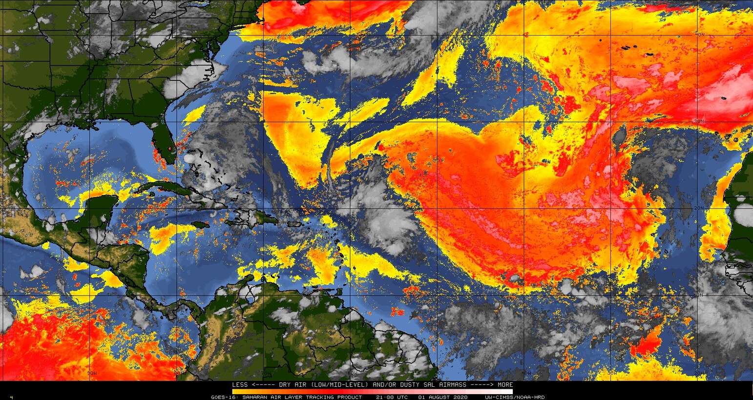
- the dry and dusty Saharan Air Layer air isn't as much of an inhibiting factor:

As for storm surge, from the tidesandcurrents website water levels are not yet a foot above normal - here's an example from Biscayne Bay, Florida:
Quick reminders of a few things: Eat ice cream. Oh, and listen to your local emergency managers because they have the best info for your area. And remember - run from the water, hide from the wind, which means that if you are in an area that gets flooded, then try and move away if you can (trickier this year, I know!). Have some wine and cheese (which is what I'm doing at the moment). 

Tropical Depression 10
She's currently quite far north already at 19.2N, 23.5W heading NW at 13mph. She's actually hanging out near the Cape Verde Islands and there is hardly any circulation nor any convection to write home about: 

 So I'm not going to write home about this one anymore. :-)

Be back tomorrow, of course!
Toodle pip,
J.

Twitter: jyovianstorm
--------------------------------------
DISCLAIMER:
These remarks are just what I think/see regarding tropical storms - not the opinion of any organization I represent. If you are making an evacuation decision, please heed your local emergency management and the National Hurricane Center's official forecast and local weather service announcements. This is not an official forecast. If I "run away, run away" (Monty Python), I'll let you know. 
--------------------------------------

Hurricane Isaias and Tropical Depression 10: July 31, Update A

Got my ice cream, so I'm jumping right in. To the storms and writing. Not jumping into the ice cream. Although by the end of this year, I may have to do that. ;-) 

Hurricane Isaias
He's come into line now and is behaving as predicted. He's still a weak cat 1 storm with winds of 80mph, central pressure 987mb (cat 1 range: 74-95mph). He did weaken a little earlier today, but only to 75mph winds, so no change in category. He is still hanging out in the Bahamas at the moment:

Not too much change since yesterday really - there is a bunch of rain and some quite thundery weather, as you can see from the dark red areas in the satellite imagery. There is still some wind shear, pushing that stream of clouds off to the north and east. I suppose the one small good thing with all this rain is that it has cleaned out some of the dust, which causes it's own respiratory issues. However, he's now pretty much broken through the SAL, so that will no longer really be an inhibiting factor:

He has slowed down a little and is currently at 23.3N, 76.4W, heading NW at 15mph. I think he may slow down a little more. And, just because this is 2020, after the Bahamas, the track of course takes him along the entire Florida coast and then, all the way along the eastern seaboard:
I will still have to go along with the NHC on the because their data is better than mine. Of course, don't focus on the middle of the track (or on one side or other) because, you know... 


Teehee. 

Regardless of track, he'll have a lot of rainy weather because the Florida Current and Gulf Stream run along that eastern side of Florida and along the Georgia/Carolina coasts. This current system has deep warm water - at least the upper 100m or so is warmer than 26 deg C.  This current system may give him a boost towards slight intensification tomorrow, after he's stopped interacting with the Bahamas and is crossing over towards Florida. 

Some scenarios: If he skirts the western side of that cone, that's directly over coastal Florida which will have a small damping effect because he's partially interacting with land. If he stays on the eastern side of the Cone of Uncertainty, then there's a possibility that all you'll get along that coast is some good surf. 

There is another scenario - the track (and Cone of Uncertainty) will shift a little more to the west, which means he may go a little more up the middle of Florida. In this scenario, the reason he may get a little stronger is because he'll be over the Everglades (essentially water with a few blades of grass) and, more importantly, he will get stronger if he goes over Lake Okeechobee. There have been quite a few storms than intensify if they pass right over that lake because it is so large. These are all still a few days away, but everyone in Florida should be ready for at least some cloudy weather, and most likely some raindrops on roses and whiskers on kittens!

Tropical Depression 10
This is the Atlantic Blobette that came off Africa a couple of days ago. She's so far over yonder that I'll look at her tomorrow. The next name is Josephine. 

More tomorrow!
Ciao for now,
J. 

Twitter: jyovianstorm
--------------------------------------
DISCLAIMER:
These remarks are just what I think/see regarding tropical storms - not the opinion of any organization I represent. If you are making an evacuation decision, please heed your local emergency management and the National Hurricane Center's official forecast and local weather service announcements. This is not an official forecast. If I "run away, run away" (Monty Python), I'll let you know. 
--------------------------------------

Friday, July 31, 2020

Hurricane Isaias: July 30, Update A

It's Thursday again, isn't it? Wasn't it just Thursday a couple of days ago? I never can get the hang of Thursdays... they are especially rocky when there's an earthquake (a good pun is it's own re-word by the way). ;-) 

Still, the two pieces of good news from today are that we (humans) have three missions on their way to Mars and, of equal importance of course, that we (the NHC and I) are finally in agreement over Hurricane Isaias!

They increased his intensity, which I fully agree with.... Isaias is now a fully-fledged hurricane. This makes a lot of sense given that there has been a vorticity (circulation) signal in his upper troposphere (sign of a hurricane!) since yesterday. It's still not perfectly round and contained, so a cat 1 seems reasonable - he's currently a weak cat 1 storm with winds of 80mph, central pressure of 995mb (cat 1 range: 74-95mph). You can see that he's got a lot of convection (rain, thunder, and I expect tornadoes in there somewhere) from the infrared satellite imagery:
There isn't a clear eye and the convection doesn't quite wrap around the center fully which aligns with winds around 80mph (and eye starts to appear somewhere around 90mph). 

He is still being impacted by wind shear, which we can see as the clouds stream off to the northeast. And he also still has dry and dusty air ahead of him, which is still keeping his convection in check. 

As for his track, he did turn to the NW overnight/during the day today and he did go over Hispaniola, which is as the NHC forecast. For the most part along the Greater Antilles he wasn't as much of a wind issue as a rain and thundery weather sort of storm. I heard things are ok on St. Thomas, apart from a propane gas explosion that blew up a yacht in a marina earlier in the week (just because this week was going to be slow). 

Once they had the center location, that track forecast improved dramatically. His center is now at 20.4N, 72.2W and he's heading NW at a more reasonable hurricane pace of 18mph. It is a little more straightforward from here on out, so I would agree with the NHC track: 

As he crosses the Turks & Caicos and Bahamas, I expect he will get a little stronger - most likely a mid-to-strong cat 1 (but no more than a weak cat 2). As I said, he has some dry and dusty air ahead of him as well as that wind shear. And if his center goes directly over one of those islands, it will help keep his intensity in check - even just a very little.

That track forecast is now better than any data I have, so I'll go with that. Keep an eye on the entire cone of course, not just the center. 

Also, just in case those of you in Florida haven't seen this yet - your Emergency Managers have been busy working with hotels across the state to set up shelters that allow for social distancing. The link takes you to a website/map with those places. The notice when you get to this site says that all decisions on using those shelters will be made by local emergency managers. 

I think that's almost all for this Thursday. I'm also keeping half an eye on the new Atlantic Blobette that's just come off the coast of Africa - currently around 12.5N, 20W. She has a 40% chance of developing in the next 48 hours. I'm not going to mention her unless she gets a little more robust. 

More tomorrow!
Toodles,
J. 

Twitter: jyovianstorm
--------------------------------------
DISCLAIMER:
These remarks are just what I think/see regarding tropical storms - not the opinion of any organization I represent. If you are making an evacuation decision, please heed your local emergency management and the National Hurricane Center's official forecast and local weather service announcements. This is not an official forecast. If I "run away, run away" (Monty Python), I'll let you know. 
--------------------------------------