Got my ice cream, so I'm jumping right in. To the storms and writing. Not jumping into the ice cream. Although by the end of this year, I may have to do that. ;-)
Hurricane Isaias
He's come into line now and is behaving as predicted. He's still a weak cat 1 storm with winds of 80mph, central pressure 987mb (cat 1 range: 74-95mph). He did weaken a little earlier today, but only to 75mph winds, so no change in category. He is still hanging out in the Bahamas at the moment:
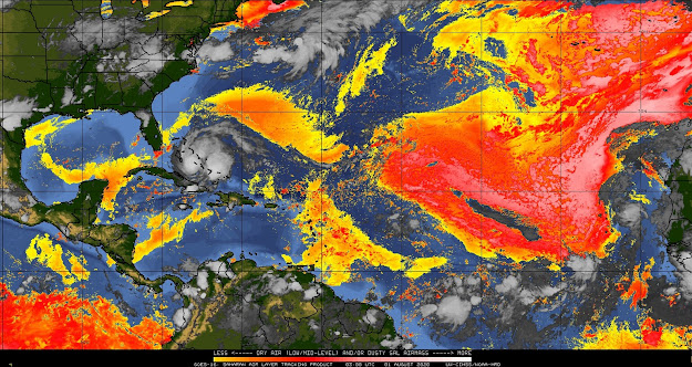
Not too much change since yesterday really - there is a bunch of rain and some quite thundery weather, as you can see from the dark red areas in the satellite imagery. There is still some wind shear, pushing that stream of clouds off to the north and east. I suppose the one small good thing with all this rain is that it has cleaned out some of the dust, which causes it's own respiratory issues. However, he's now pretty much broken through the SAL, so that will no longer really be an inhibiting factor:
He has slowed down a little and is currently at 23.3N, 76.4W, heading NW at 15mph. I think he may slow down a little more. And, just because this is 2020, after the Bahamas, the track of course takes him along the entire Florida coast and then, all the way along the eastern seaboard:
I will still have to go along with the NHC on the because their data is better than mine. Of course, don't focus on the middle of the track (or on one side or other) because, you know...
Teehee.
Regardless of track, he'll have a lot of rainy weather because the Florida Current and Gulf Stream run along that eastern side of Florida and along the Georgia/Carolina coasts. This current system has deep warm water - at least the upper 100m or so is warmer than 26 deg C. This current system may give him a boost towards slight intensification tomorrow, after he's stopped interacting with the Bahamas and is crossing over towards Florida.
Some scenarios: If he skirts the western side of that cone, that's directly over coastal Florida which will have a small damping effect because he's partially interacting with land. If he stays on the eastern side of the Cone of Uncertainty, then there's a possibility that all you'll get along that coast is some good surf.
There is another scenario - the track (and Cone of Uncertainty) will shift a little more to the west, which means he may go a little more up the middle of Florida. In this scenario, the reason he may get a little stronger is because he'll be over the Everglades (essentially water with a few blades of grass) and, more importantly, he will get stronger if he goes over Lake Okeechobee. There have been quite a few storms than intensify if they pass right over that lake because it is so large. These are all still a few days away, but everyone in Florida should be ready for at least some cloudy weather, and most likely some raindrops on roses and whiskers on kittens!
Tropical Depression 10
This is the Atlantic Blobette that came off Africa a couple of days ago. She's so far over yonder that I'll look at her tomorrow. The next name is Josephine.
More tomorrow!
Ciao for now,
J.
Twitter: jyovianstorm
--------------------------------------
DISCLAIMER:
These remarks are just what I think/see regarding tropical storms - not the opinion of any organization I represent. If you are making an evacuation decision, please heed your local emergency management and the National Hurricane Center's official forecast and local weather service announcements. This is not an official forecast. If I "run away, run away" (Monty Python), I'll let you know.
--------------------------------------


No comments:
Post a Comment