Today is brought to you by the number Three.
R.I.P. to the truly iconic R.B.G....
She said: "Some of my favorite opinions are dissenting opinions." and "You can disagree without being disagreeable."
This nicely sets the stage for the next thing I bring to you by the number Three.
The NHC named three storms today. <Very Minor Rant Alert!>Although it is too late and the deed is done, I disagree (without being disagreeable of course) with this silliness because one should definitely not have been named, one is more of a front than a storm, and the third has pretty poor structure for a Tropical Storm. This is not the first time that three storms have been named on the same day, by the way. Back in the 1890's three were identified (pre-naming thought) - and that's in an era without airplanes. Actually, until around the 1940s there weren't planes, let alone satellites, so who knows how many were missed! If we didn't have satellites today, at least 2 of the three today would not have been named either. <End of Very Minor Rant Alert!>
But first, let's look at the only actual important storm out there...
Hurricane Teddy
He is at 24N, 57.4W, heading NW at 13mph. Bermuda is in the clear and well outside the Cone of Uncertainty. Well done, Bermuda! I think this track is pretty good at least until Bermuda because it's so narrow. Beyond that it is still all over the place - there's a good possibility that he'll stay on a more eastward track after Bermuda and barely clip Newfoundland - i.e. staying to the east side of the Cone. But get ready regardless up there!
As for intensity, winds are 130mph, central pressure is 948mb. This makes him a borderline Cat 4/cat 3 storm (cat 4 range: 130-156mph). I think he's weaker than this - I'd place him on the cat 2/cat 3 border actually - with winds of around 111mph at the most. His convection took a bit of a hit from that dry air I mentioned yesterday, combined with that little bit of wind shear:
You can see that his strong eye clear eye, very classic for a cat 4 or 5 storm, closed up and an area of drier air intruded and has also reduced the convection in his outer bands. That wind shear will continue for another day or so I reckon, and he still has drier air to his west that will continue to get pulled into him:
Here's the map from the mid-troposphere (500mb):
And here's the map from the upper troposphere (200mb):
Teddy definitely has the circulation structure of a Hurricane and a fairly strong one at that. Tropical Storm Wilfred
Winds are 40mph, central pressure is estimated to be 1008mb. This means he's barely a Tropical Storm (and should not have been named!). His convection is very weak for a Tropical Storm...
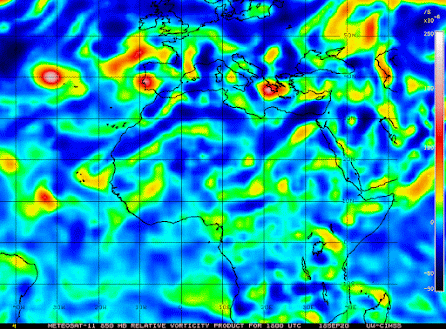
(First, find Portugal) This map shows the only time where there was even remotely a red circular-ish vorticity patch in this lowest level of the troposphere - however even at this time, it was still connected to a much broader area of low pressure that extended from Spain into the Atlantic. On either side of this snapshot, the map looked like this:
And the vorticity was not circular, but rather elongated connected to other patches of high vorticity - low pressure systems. And as for the mid-troposphere, that's even more of a low pressure system, and not a tropical storm:
That is the vorticity map that corresponds to the one when she 'formed'. That is most definitely NOT a Tropical Storm structure!
Again, this one doesn't have the structure of a Tropical Storm as you can see from the vorticity maps above. The vorticity in the lower half of the troposphere is elongated - and in the mid-tropopshere, it actually extends northeastward towards LA/MS/AL/FL and then up to North Carolina - which means it's actually a low pressure front!
There is a lot of convection which is to be expected as this is over very warm 30 deg C water, with the upper 75m plus warmer than 26 deg C. But you can also see different areas of very strong convective outbursts - which is why I'm not sure they have the center in the right place (because it doesn't really have a center). There is a lot of wind shear which we can also see in the satellite imagery as the clouds and rainy weather is being swept up towards the northeast. We'll see if that circulation actually becomes more circular tomorrow but today it's messy.
J.
p.s. and just as I was posting this on twitter, we had a 4.8 or 4.6 magnitude earthquake here (there are conflicting reports on magnitude) - that's the largest I've ever felt! A lot of shaking and things rattling!
Twitter: jyovianstorm
These remarks are just what I think/see regarding tropical storms - not the opinion of any organization I represent. If you are making an evacuation decision, please heed your local emergency management and the National Hurricane Center's official forecast and local weather service announcements. This is not an official forecast. If I "run away, run away" (Monty Python), I'll let you know.
--------------------------------------


No comments:
Post a Comment